|
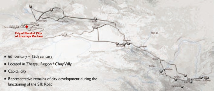
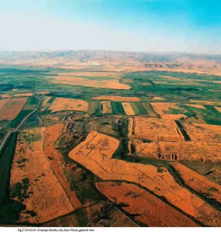
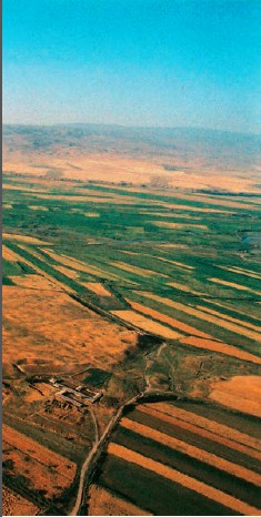
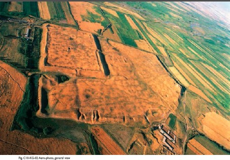
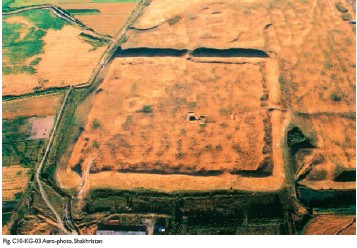
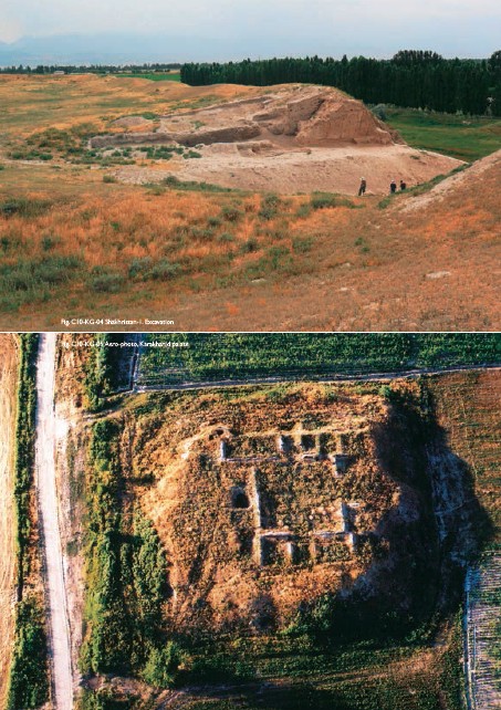
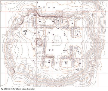
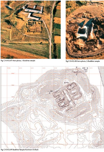
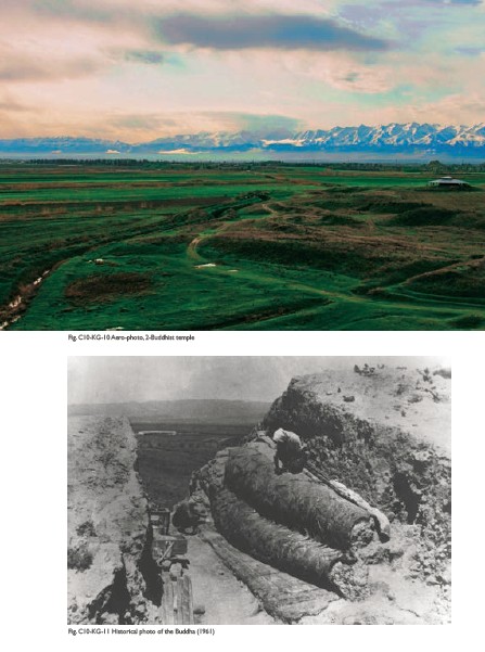
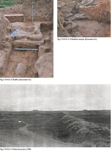
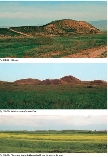
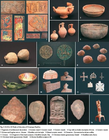
(1) Contribution to the Silk Roads' OUV The city of Nevaket has long been one of the most important of all the urban settlements in the Chui Valley and in the Tian-Shan region. A blend of Turkic, Indian, Sogdian and Chinese cultures can be seen in the materials used in both the religious and civil buildings, constituting a fascinating expression of regional cultural dialogue. Archaeological excavations in and around the town have revealed a Zoroastrian grave site in the western suburbs, Nestorian Christian votive stones in the Citadel and Buddhist temples south of the town walls. Among the early mediaeval Buddhist buildings that have been excavated in the Chuy Valley, temples of Nevaket (Krasnaya Rechka) are the only that have been well preserved. (2) General Information The Krasnaya Rechka site, situated 40 km to the east of Bishkek, is the largest medieval settlement in the Chuy valley. It is identified as the city of Nevaket. The area of its central ruins include two Shakhristans and an extensive enclosure to the West of them, including the western and southern extensions, - covering about 100 hectares, the area of the suburb (Rabad) surrounded with a long wall covers nearly 20km2. Archeological researches revealed several building periods: the first (upper) is related to the Karakhanid period – 10th-12th century A.D.; the second is related to the Turgesh-Karluk period – 8th-10th century A.D. Cultural layers belonging to the 6th-8th century A.D. and the lowest belonging to the 5th-6th century A.D. were also discovered in the Rabad and the second Shakhristan. (3) Attributes Ruins of Kransnaya Rechka site cover an area of more than 400 hectares, and the total excavated areas so far cover not more than two hectares. The Kozhemyako city plan (1940, 1950) and the following archaeological excavations revealed: Shakhristan 1, Shakhristan 2, the Citadel within city walls, and a Rabad (suburbs). Shakhristan 1 along with Citadel occupies 46 ha. City entrances are traced in the eastern and northern walls. Shakhristan 2 occupies the northwest part of ruins with a total area of 19 ha. Two Shakhristans are linked with the defensive walls and a deep ditch filled with spring water. Fortifications were monolithic without loopholes and galleries. The whole site slopes slowly downwards from south to north towards the Chu River. Tributaries of the Krasnaya Rechka River in the higher south side of the valley irrigate the territory. That is why the Karakhanid Palace (KP) located on top of a raised platform 1km south of the Citadel and Shakhristan 2, represents the highest absolute level of the site, higher than the Citadel. The Citadel is located at the south-east corner of the walled Shakhristan. With a relative height of 21m above the surrounding plane, the Citadel is the highest structure of the entire site. The hollow western slope might indicate historical access to the citadel. At the top of the Citadel rooms, walls,benches, or sufas of mud-bricks from the 2nd construction horizon, can still be retraced in the present day situation. Deep trench through the northern wall of the Citadel reveals composition of wall parts with different construction techniques belonging to different building periods. The upper inner part is made of pisé or pahsa blocs of small dimensions and measures between 1.5 and 2m in width. The outer part is mud-brick masonry. Its profile runs 9m high and 7.5m wide. The southern city wall measures 1km. It starts at the citadel in the east, runs w-s-w for 250m, is cut by the main access road to the Shakhristan, makes a slow turn and continues for 750m in w-n-w direction. The top rises approximately 10 m above the surrounding plane. At 200m from the western end, the city wall is interrupted by a wide and gentle slope: 25m wide at 17,7%. Elsewhere the city wall shows a steep slope of 40% (presently). This gentle slope leads straight to the central axis of Shakhristan 1. It is interpreted as an entrance to the city. Immediately east of this slope, the Kojemyako-trenches were excavated. The trenches are 50m long, 6m wide, and maximum 5-6m deep. Karakhanid Palace (KP) The square platform measures 60m at the bottom and 40m at the top. Four horizons of different construction periods were found. A central square courtyard was surrounded by four wings with rooms. The access to the complex was planned along a N-S-axis with slopes leading to entrance halls on both sides. In the most recent building periods, a circular platform for a yurta of 2 courses of burnt brick dated to the 11-12th centuries appeared in a second courtyard at the west-side. In the first and second building periods, dated 10th century, the courtyard had a row of 4 columns, probably carrying a shed in front of the northern wing. A pattern of rectangular floor-tiles is present. The building was marked by circular towers at each corner of the square-shaped plan. The north-western tower was excavated and documented. Ventilation channels and a water tube were also found. The other 3 towers are assumed but probably still existing, wholly or partly. The northern entrance hall had small benches on either side. The inner courtyard of 2nd and 3rd period had sufas or benches in front of the eastern and western wall. In the northern wing were located the most representative rooms. According to excavation reports, many pieces of preciously carved clay were found here, occasionally covered with traces of lime and mineral paint. Housekeeping rooms were grouped in the western wing: kitchens with hearth, pantries, etc. The Karakhanid house east of the Second Buddhist Temple is dated to the 10-11th century. The area of Buddhist Temple 1 (B1). Now, the first Buddhist Temple doesn’t exist, what is left are the remains of a Sogdian castle on a lower horizon. This castle occupies a square area of 75×75m with the most important part in the northern quadrant. The castle was found on the lower third construction horizon, probably from Sogdian time (6-7th century). The dimensions and location of the outer walls correspond to the thick outer walls of the castle (>6m). The corners are fortified by octagonal towers. The shape of this protrusion is repeated in trapezium-like buttresses half-way along the massive outer walls. Buddhist Temple 2 (B2). This structure is dated to the 7th –8th century. The temple covers an area of 17×17 m, composed of a sanctuary room of 6x5 m with a domed roof and a roofed ambulatory corridor. The remains of a reclining eight-metre-long clay statue of the Buddha were unearthed in the back corridor by Kojemyako (1961), and Bodhisattvas discovered in the southern corridor and at both sides of the sanctuary gates (now in the Hermitage Museum, Saint Petersburg). Fragments of wall paintings, a Chinese stela with carvings and inscriptions, fragments of a Sanskrit manuscript on birch-bark in Brahminical script, together with gilded bronze statuettes of Bodhisattvas and deities of Sogdian and Indian origin have also been found. Fragments of frescos were also discovered. The building’s plan and construction are similar to that of the first temple discovered, and the reclining statue of the Buddha mentioned above is similar to a clay sculpture found at the Ajina-Tepe Buddhist temple in Tajikistan. The Buddhist Temple 3 is situated in the far west of the Krasnaya Rechka site within a complex of constructions surrounding the second most prominent hill (also called Fire Temple) at a distance of 1300m from the Citadel. Stamped curls of hair of a big sculpture have been found, similar to finds from the first Buddhist temple. In addition, discoveries of large pieces of red sculptural clay in a southern corridor allowed identifying this construction as a Buddhist temple, proved conclusively in 2011 when excavation revealed the clay sculpture of Buddha. In connection with the find of the Buddhist temple which is part of a bigger complex it is possible to assume that the central hill is a big Stupa, and the whole complex is the largest Buddhist monastery in Zhetysu. The temple complex measures 250x150m and is part of the larger necropolis, extending to north and south. The necropolis is a special place on the site, consisting of a northern necropolis and southern necropolis. Situated outside the Shakhristan, the northern necropolis and temple complex are nevertheless connected to it as a kind of additional city. Their outer walls are lined up with the city walls of the 1st and 2nd Shakhristan (S1, S2), only separated by a ditch and a swampy area. Today only the most northern connection still exists. The southern wall, lined up with the southern city wall of Shakristan 2, is visible on the surface by a crop-mark. The southern necropolis is a series of hills not attached to the Shakhristan, The Zoroastrian burial places were excavated in 1980s. Many ossuaries of rounded and oval form, with natural, anthropomorphic or architectural decorations were found in pits, dug out in a small hill or a tumulus as well as in full earth. Nauses are built receptacles made of burnt bricks, mud-bricks, or pisé. The nauses contain the bones directly or indirectly by the ossuary (ossuaries). The architecture is most often simple: a small rectangular vaulted room or a doomed square. More complex nauses are found with several rooms along a central corridor. It is supposed from the majority of the nauses found at Krasnaya Rechka that bodies decomposed and then bones deposited in a receptacle afterwards. Excavation 4 near the southern necropolis revealed a multi-chamber naus with six chambers disposed symmetrically along a central rectangular space. One of the two most elaborate ossuaries found depicts priest-like figures with specific attributes such as mouth-masks, belts, and maintaining a fire on an altar.
|
 |Archiver|小黑屋|丝路遗产丝绸之路:长安天山廊道的路网
( 陕ICP备07011065号-3 )
|Archiver|小黑屋|丝路遗产丝绸之路:长安天山廊道的路网
( 陕ICP备07011065号-3 )
GMT+8, 2024-4-24 21:38 , Processed in 0.745969 second(s), 20 queries .
Powered by Discuz! X3.5
© 2001-2024 Discuz! Team.