(1)Contribution to the Silk Roads' OUV Archaelogical complex Akyrtas is an example
of the spread of architectural styles at a great distance. Analogies to the
unique layout of the palace of Akyrtas lie in architecture of the Middle East.
The palace was built with the involvement of Arab architects with the use of
architectural traditions of the Middle East. Very similar was the plan of
palaces of Samarra in Iraq, as well as the palaces of Syria and Jordan, in
particular, known for its magnificent palace of Qasr al-Khaiyr al-Gharbi. (2) General Information Archaeological complex Akyrtas is located
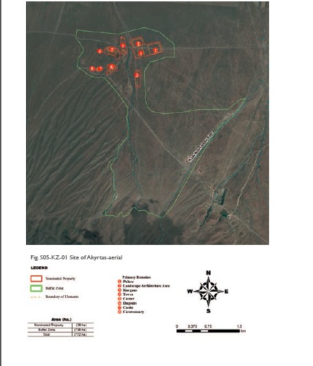
in foothills of the Kyrgyz Alatau. Architectural and archaeological complex
Akyrtas includes various different time monuments in chronological range of the
5th century BC to the 16th – 18th centuries. Monuments spatially linked to the
natural terrain, called "Kyzyltau" as well as the dry season channel,
fed by numerous channels of foothill depressions, filled with water in spring
and autumn. Size of the complex is about 3 km to the east-west and about 5 km
to the north-south. The composition of the Akyrtas archaeological complex
consists of undeveloped palace structures and objects on the adjacent areas on both
sides of the dry river bed. These are: a park, two caravanserai, farms,
watchtower, clay pit, stone quarry pit, a fortress, castle mounds, plumbing,
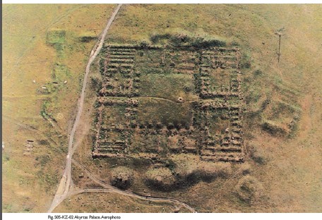
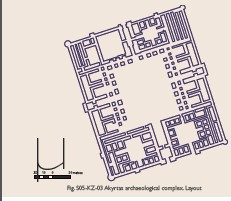
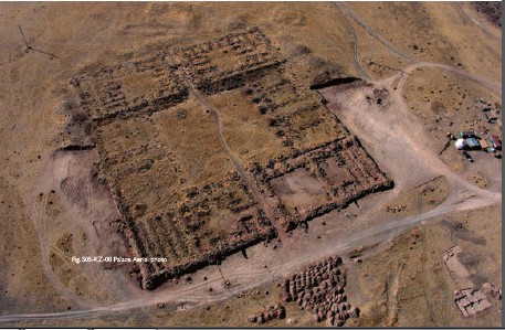
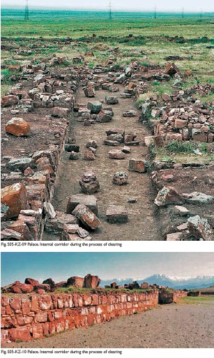
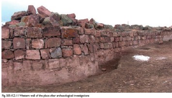
howz-reservoirs. Akyrtas palace-fortress is a rectangular in terms structure in
size of 180 x 205 m longitudinal sides oriented in the north-south line. The
walls of massive stone blocks of red sandstone were built to a height of 1 to
1.5 meters. Blocks laid in one, two, sometimes three or four rows. The width of
the walls varies from 5 m at the outer up to 3-3.5 m in the interior. The walls
are made of two rows of blocks in filling the space between the gravel and
clay. Some of the units have carefully crafted a smooth outer plane. The aisles
perpendicularly located inside divide the building into four parts, three of
which are composed of rooms located around a courtyard, and the northwestern one
is free of buildings. Center of the whole building is the courtyard, the
perimeter of which is surrounded by the stone bases of columns in size of 5 x 5
meters. In the southern part of the yard can be traced pits of two
howzreservoirs. Main longitudinal passageway connects the northern and southern
entrances. Perpendicular to it is the passage from west to east rests against
the deep iwans. The first part of the structure consists of a vacant area of
the square with a side of 27 m and group of rooms facing the courtyard (13 x 18
m). Of these, three are long corridor type premises. The second part consists
of two groups of rooms: living room of 12 and 3 iwans grouped around a
courtyard and economic one, where there were 5 long narrow premises with a
width of 2 to 3 meters, facing the courtyard. In the third part there are13
rooms grouped around a courtyard, which has a separate exit to the outside.
Fourth part is residential, joint by yard in size of 25 × 34 m. It has 18
rooms, 2 iwans and 3 narrow spaces, one of which is П-shaped.
This part also has its own way out. The pottery fragments are represented by round-boilers
with traces of soot. There are also fragments of larger hum and water pitchers.
The castle is located 1km to the southwest of the palace complex and it is
almost quadrangular in plan structure with dimensions 39 × 40.5. The
construction is oriented to the cardinal points. The entrance is in the center
of the eastern wall. The outer walls are made of mud brick and internal ones,
also mud, mounted on stone plinth of red sandstone. At the corners of buildings
there are towers, circular in cross section. Inside the center there is an open
courtyard, located along the perimeter of the room. Building has two
construction periods. Castle, 1 km to the southwest of the palace, is located
on the natural hill, next to the fortress. It is a rectangular area with
dimensions of 40 × 25 m, height of 3-3.5 m, oriented by longitudinal sides of
the eastwest with a little slight shift. The walls of the large mud bricks on a
stone plinth of red sandstone are also faced with it. Inside, along the
longitudinal axis there are three adjacent rows of three rooms square in the
plan, combined from the western side by longitudinal premise. 14 century homesteads
are located to the north from Akyrtas. They form an area of residential
buildings, fenced with mud wall, with a total area of about 2.5 hectares, the
size of the parties 280 × 180 m. In the last period of its existence the castle
was turned into the caravanserai 10th-12th centuries. The estates
are of type of walled rectangular plots with howz-reservoirs and dwelling
spaces. Estates square reached 100 m. Total number of such estates found on the
northern side is 10 and 2 on the southern. In addition to the estates on the
dwelling territory marked houses, built side by side, with the plan dimensions
of 10 × 10 m. The caravanserai is at 30 meters northwest from Akyrtas is a
closed rectangular plot with the plan dimensions of 43 × 49 m, walled thickness
of about 1 m of stone, height of 0.5 m. The entrance is located on the southern
side. On the territory of the caravanserai there are two hills. The second
caravanserai consists of two adjacent rows of 3 rooms, finished with the wall
elongated along the eastern side of the transverse of the room where were found
a lot of parts of fragments of water pipes. The walls of the caravanserai
preserved to a height of 0.65m. On the base of height of 0.6 m of red sandstone
there are walls laid of burnt brick (13th-14th centuries). The park is a part
of territory, surrounded by a wall with the side of a square 250 m. From the
eastern side the area is adjacent to the bed of the channel, where the water
stream goes in spring time. In addition, it is lead by canal bed which goes to
the direction of the gorge Shoshkola. Watch tower is located to the west of the
palace, on the top of the mountain Kyzyltash. It is made of stone. Preserved lower
row of stones forms a circle with a diameter of 5 m. There is a stone ground
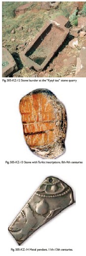
near it. Quarry is 400 meters long. In its territory there are numerous
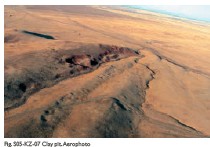
semi-manufactured and processed stone blocks. Clay pit covers an area of approximately
1.5 hectares. Layer of loess slope served as material for burnt brick. Found
the remains of brick kilns, fragments of burnt brick, slag. Dugouts are oval depressions,
deepened into the hillside. The plumbing is the ceramic cone-shaped tubes
inserted in the form of links to each other. Link length is 50-60 cm, diameter
of wide end is 20 cm and a narrow one is 18 cm. The
plumbing is laid to a palace complex from water intakes and springs of
Shoshkala and Uzunbulak gorges. Reservoir in Uzunbulak gorge is generated by rock-earth
dam, which blocked the gorge formed by the rock ledges. Near residential areas
there was another reservoir, from which there was distribution of water through
the pipes of a smaller diameter to the houses of estates and dwelling houses.
To the north from Akyrtas there are two reservoirs. One of them, the western one,
is square in plan with a side of pit of 40 m, and depth of 2 m. Eastern
reservoir diameter is 30 m. The water accumulated here, was intended to
irrigate crops, located north from Akyrtas. (3) Attributes Archaelogical complex Akyrtas is an example
of the spread of architectural styles at a great distance. Akyrtas is a sort of
a unique set of multi caravanserais, located in a small compact area and dating
back to the chronological range from the 11th to 14th centuries. At Akyrtas
site were investigated buildings, directly or indirectly related to the
maintenance and development of trade. An extensive network of hydraulic
structures, gardens and parkland created the necessary facilities for living,
commerce and industry. The various fortifications and signal facilities were
created to provide security and to facilitate unimpeded trade along the Silk
Roads. The location of Akyrtas at the distance of two farsakhs between the
medieval towns Lower Barskhan and Kul-Shub is not accidental – it is equal to
the day-shift caravan. Akyrtas itself was associated with Karluk quarter –
Kasribas. In the construction of the city were used local stone and clay, as
evidenced by the carriers of its extraction. Akyrtas is located in the foothill
of the Kyrgyz Alatau, in a territorial corridor between the Kyzylkum desert,
the transition through which due to the lack of water sources was difficult,
and the mountain range, which supplied the caravanserais of Akyrtas with water.
One of the distinctive features of Akyrtas is a complex system of collection
and conservation of water resources, which mainly had a seasonal character,
using the lay of land and the combination system of arrangement of kuburs,
irrigation ditches, howz-reservoirs. Mountain Kyzyltau around which were
located all the buildings of Akyrtas, was a source of building materials – red sandstone
and loess-like loam. The system of collection and preservation
of water in abundance available in spring and autumn periods, by accumulating
it in the reservoirs and its subsequent use in the summer season is a tradition
of people living in the foothills regions of Alatau and Karatau. The existence of a post road in the 19th
century, as well as the construction and use of the transport corridor Western
Europe – Western China laid in close proximity to Akyrtas, is an evidence of
the existence of a system of values and traditions that have roots in the
Middle Ages.
|
 |Archiver|小黑屋|丝路遗产丝绸之路:长安天山廊道的路网
( 陕ICP备07011065号-3 )
|Archiver|小黑屋|丝路遗产丝绸之路:长安天山廊道的路网
( 陕ICP备07011065号-3 )
GMT+8, 2024-4-20 12:16 , Processed in 0.200487 second(s), 20 queries .
Powered by Discuz! X3.5
© 2001-2024 Discuz! Team.