|
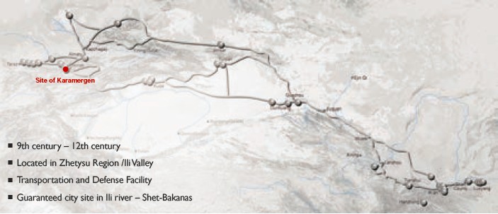
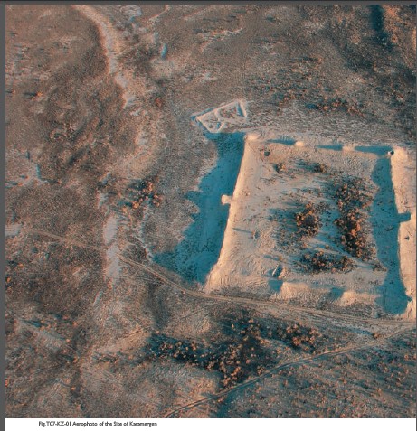
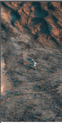
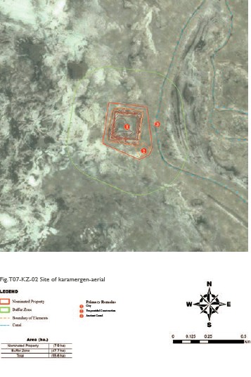
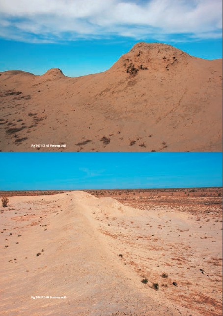
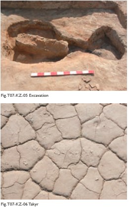
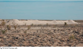
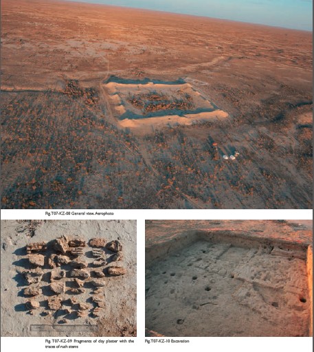
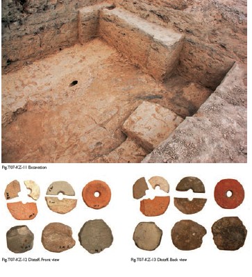
(1) Contribution to the Silk Roads' OUV Karamergen was the largest and most northern medieval city of agricultural civilization in the ancient delta of the Ili river in the 9th – 13th centuries. City appeared in the lower fertile reaches of the ancient delta of Ili river – Shet- Bakanas, on the segment of the Silk Roads route. The closest and convenient trade way from Zhetysu to the Eastern Turkestan to the territory of Central and Northern Kazakhstan passed through Karamergen. It was the most direct way. For example, the way from Almalyk (Kuldja) to Bozok (near modern Astana) through Karamergen was not less than 3000 km and any other was longer to 500- 1000 km. Karamergen served as an important transit point of Balkhash section of the Silk Road leading to Central Kazakhstan, and thence to Eastern Europe. (2) General Information Karamergen is located in Southern Balkhash lake, 200km northeast of the village Bakanas, 3 km north from the confluence of the dry riverbed of Ortasu into Shet- Bakanas. Ancient settlement dates back to the 9th –13th centuries. The settlement dominates the surrounding area of 1.5-2 meters. Karamergen is located on a flat surface, bounded on one side of the high sandy ridge, the other one – the old river channel. Ancient settlement is of a rectangular area, its size is 115 × 120 m, oriented to the cardinal points. The walls are up to 3 m. At four corners there are round towers of 4.5 meters. Northeastern and southwestern sides have two more round towers, preserved to a height of 3.5 meters. At 20 meters to the east of the southern tower there is a trapezium structure, surrounded by a slipped down rampart in height of 1.5m. Western tower had a conical shape, on the top was arranged a rifle square of 3 m in diameter, surrounded by a brick parapet. For the construction of the tower was used adobe bricks measuring 55 × 25 × 8.5 cm. Defensive wall is built of mud bricks, pakhsa blocks and pieces of raw clay, plastered on the outside. In the rabad area there were excavated three kilns of ceramic vessels, as well as the richest surface material: fragments of ornamented and non-ornamented ceramic coated with colored engobe. Here were discovered products of jewelers and blacksmiths, made of iron and non-ferrous metals, as well as jewelry from colored glass and semiprecious stones. On the territory of the settlement in the cultural layer encountered numerous inclusions of bone, ceramic, terracotta and household waste. Cultural layer lies directly in the ancient burial ground. On the surface of the settlement and surrounding takyrs was revealed a large collection of pottery and copper slag, indicating that Karamergen was the center of copper-founding production. To the north from the settlement, on the banks of a small reservoir there were cleared the remains of the pottery kiln. Water supply of the settlement was carried out mainly through the Akkum channels, branching from the western Shet-Bakanas, which dry bed is one of the large ones. It is situated between Ortasu and main (east) channel of the Shet-Bakanas. The width of the channels is 10-15 m. Along the banks there are preserved remains of rampart in width of 5-7 m and height of about 1 m. Water from the canal to the ancient settlement was fed through the channel, which can be followed by very slipped down rampart in the middle. Bed width is of 5-7 m, depth is of approximately 1 m. Channel length is of about 10 km. Not far from the source of the main canal of Karamergen there are remains of the dam, which served to raise the water level in the canal and feeding it to channel by gravity feed. In the upstreams of Ortasu canals there were recorded three more dam remains crossing the main channels of Bakanas. On the surface they can be traced in the form of slipped down ramparts in width of 3-4 m and a height of 1.5-2 m. Near the dam, in the neighborhood territory, there are remains of the fields in the form of a well-planned land separated by rollers into rectangles, diamonds, squares. Roller width is 0.5-0.7 m, height is 0.3-0.4 m. Area of plots varies: 10 × 12 m, 12 × 15 m and 20 × 20 m. From the southeastern side of the site at a distance of 0.8-1 km there is a trunk, derived from the bed of one of the current flow of anhydrous Ortasu river. The second channel is located 2 km west of Karamergen, its channel runs from southwest to northeast, to the shore of Balkhash lake. The preserved length of the channel is 10 km. (3) Attributes Karamergen is the most fortified settlement characterized by powerful defensive walls with angled twin towers, "L"- shaped ramps, ditches. All these elements of fortification were an integral basis of defensive architecture that ensured the safety of caravans. Agro-irrigation system based on river ducts with dams, howz-reservoirs, main canals and channels of the second-level, distributors, planned areas of the fields which were also the basis for maintaining the viability of not only the city but also the caravans passing through this desert. Overcoming by the caravans the segments between the towns and settlements in this desert region was carried out by a device in the way of a series of wells that are not used in turn for irrigation, but only as sources of drinking water. The question of layout of Karamergen on the segment of the Silk Roads, which leads to the steppes of Central Kazakhstan, where in the Middle Ages were being developed polymetallic ores, is directly correlated with the interaction with the environment. Despite the unfavorable climatic conditions of desert expanses of the Southern Balkhash area, the place for the base of the city was chosen exactly in a territorial corridor in the area of the Saryesik peninsula and narrow strait, through which wading or using boats and rafts, and in a winter time on the ice, the caravans were able to cross the Balkhash lake, and continue movement along the river Nura and Sarysu towards the foothills of Ulytau. Only this narrow isthmus made it possible to cross the lake with the least loss of time and effort. Without access to a certain amount of water resources the construction and continuation of the existence of the town center was impossible. That is why the emergence of the settlement related to the dynamics of the ancient delta of the Ili river and the drain of highly meandering riverbeds (“bakanas”), on one of the terraces of which Karamergen is located. Life in the desert settlement is directly related to water supply, based on one of the tributaries of Ortasu passing, 1 km from the southeastern side of the settlement. The water from the ducts to the ancient settlement was fed through the channel, the remains of which can be traced for about 10 km. Not far from the source of the trunk there are remains of the dam, which served to raise the water level in the duct and its self-flowing to the channel. In the upstream of the Ortasu channels were recorded remains of three more dams blocking the mainstream of Bakanas. Near the dams, in adjacent area, there are remains of the fields in the form of well-planned plots, separated by ridges on the rectangles, diamonds, squares.
|
 |Archiver|小黑屋|丝路遗产丝绸之路:长安天山廊道的路网
( 陕ICP备07011065号-3 )
|Archiver|小黑屋|丝路遗产丝绸之路:长安天山廊道的路网
( 陕ICP备07011065号-3 )
GMT+8, 2024-4-20 17:54 , Processed in 0.210673 second(s), 20 queries .
Powered by Discuz! X3.5
© 2001-2024 Discuz! Team.