遗产数据库
巴赫莱要塞
巴赫莱绿洲的繁荣应归功于巴努·内布罕部落,这一部落从12世纪到15世纪晚期一直统治着这个地区。这个庞大堡垒的废墟有土制的城墙和碉堡以及用石头打的地基,是此类型防御工事中突出的例子,由此也可以看出巴努·内布罕部落的实力。
Bahla Fort (Oman) © Editions Gelbart
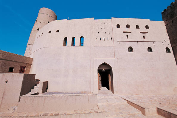
巴赫莱要塞位于阿曼北部,坐落在距离阿曼首都马斯喀特西南部约200千米处。它主要是由土砖、棕榈树干和石块建造而成,是阿曼规模空前的要塞,也是阿曼伊斯兰文化时代到来之前那段历史时期的主要历史遗迹。1987年作为文化遗产列入《世界遗产名录》。
世界遗产委员会描述:巴赫莱绿洲的繁荣应归功于巴努·内布罕部落,这一部落从12世纪到15世纪晚期一直统治着这个地区。这个庞大堡垒的废墟有土制的城墙和碉堡以及用石头打的地基,是此类型防御工事中突出的例子,由此也可以看出巴努·内布罕部落的实力。
抵御外族侵略的坚固堡垒
阿曼是阿拉伯半岛最古老的国家之一。公元前2000年已广泛进行海上和陆路上的贸易活动,并成为阿拉伯半岛的造船中心。公元7世纪成为阿拉伯帝国的一部分。1624年,建立亚里巴王朝,其势力曾扩张到东非部分海岸和桑给巴尔岛。18世纪中叶,建立赛义德王朝,定国名为“马斯喀特苏丹国”。1507年起,先后遭葡萄牙、波斯和英国的入侵与占领。1920年,阿曼被分为“马斯喀特苏丹国”和“阿曼伊斯兰教长国”。1967年,统一为“马斯喀特和阿曼苏丹国”。1970年7月23日,卡布斯发动宫廷政变,废父登基,宣布改国名为“阿曼苏丹国”并沿用至今。1973年,英国军队撤出阿曼国。
在公元16世纪到19世纪期间,阿曼苏丹统治着富有的商业王国,这个王国从东非的海岸一直延伸到印度次大陆的顶端。距离阿曼首都不远的地方是巴赫莱绿洲,巴努•内布罕部落从公元12世纪到15世纪末期间统治着这个地区。但他们时常遭到波斯人、贝都因人的侵扰。
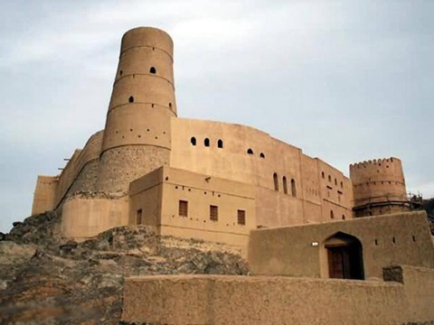
为了抵御来自海上的波斯人的偷袭,抗击沙漠游牧民族贝都因人的掠夺,以保卫家族的财产。他们修建了许多要塞堡垒和塔,最初的建筑通常是简易的堡垒和没有什么装备的避难小屋,它们最先在拥有一定人口的大城镇出现,真正的要塞则在很久以后出现,它的四周有坚固的城墙作保护,成为抵御外族侵略的坚固堡垒。今天,有不少这样的建筑保存了下来,巴赫莱要塞便是其中之一。
体现部落实力的建筑遗址
巴努·内布罕部落的统治,使巴赫莱地区繁荣发展,成为荒漠中的绿洲。这一时期,巴努·内布罕部落的繁荣和经济实力充分体现在巴赫莱要塞的建设中。
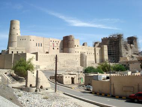
巴赫莱要塞是在砂岩的山丘上修筑的,前面是一片开阔的平地,椰树遍地皆是,巨大的巴赫莱堡垒位于比村庄高165英尺的高处。围绕要塞的城墙总长12千米,是用晒干了的砖头修建而成的。据说是在一位名为盖塔的女性的号召下,要塞从600年前就开始动工修建,直到16世纪格局才初具规模。要塞采用砖石结构,底层由数米高的大型石块作为基石,上层用砖垒砌而成。巴赫莱要塞的城墙直通巡逻小路,城墙上建有许多监视塔,至今还残留着数座方形或圆形的监视塔。其中的“风塔”早已倒塌,剩下的只是一片废墟。“风塔”曾经是阿曼的最高塔,其昔日的风采只有从19世纪末拍下的照片上才能领略到。
遗产的濒危与保护
巨大的巴赫莱要塞从未重建过,因而这些堡垒保持了绝大多数的真实性,成为这一类防御工事的典型代表。然而,由于缺乏保护措施,每年雨季过后都会有大段外墙坍塌。为了防止进一步被毁坏,这个遗址在1987年被列入世界遗产名录。1988年世界遗产委员会又将该堡垒的遗址列入世界濒危遗产目录。
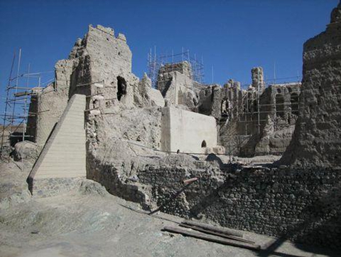
20世纪90年代初,阿曼政府开始对遗址进行修复工作,根据专家使团1996年九月访问这个遗址后的建议, 阿曼政府采取了以下措施:(1)、根据文件制定政策进行修缮,避免重建;(2)、成立一个遗址委员会,其权限包括外界环境;(3)、对特殊的建筑物进行抢修,组建一支维修队;(4)、编写详尽的,具有科学性、历史性,并且符合建筑学要求的文件,既要合乎国际标准,又要为修缮遗址所需。1993年至1999年,阿曼共花费近900万美元进行遗址修护。2004年巴赫莱要塞从濒危世界遗产名录中删除。
Bahla Fort
The oasis of Bahla owes its prosperity to the Banu Nebhan, the dominant tribe in the area from the 12th to the end of the 15th century. The ruins of the immense fort, with its walls and towers of unbaked brick and its stone foundations, is a remarkable example of this type of fortification and attests to the power of the Banu Nebhan.
Outstanding Universal Value
Brief synthesis
The immense, ruined Bahla Fort, with its walls and towers of mud brick on stone foundations and the adjacent Friday Mosque with its decoratively sculpted prayer niche (mihrab) dominate the surrounding mud brick settlement and palm grove. The fort and settlement, a mud-walled oasis in the Omani desert, owed its prosperity to the Banu Nebhan tribe (Nabahina), who dominated the central Omani region and made Bahla their capital from the 12th to the end of the 15th century. From there they established relationships with other tribal groups of the interior. Bahla was the centre of Ibadism (a branch of Islam), on which the ancient Omani Imamates were based and whose influence can be traced across Arabia, Africa and beyond.
The extensive wall (sur) with sentry walk and watchtowers enclosing the labyrinth of mud brick dwellings and cultivatable land has several gateways. The oasis is watered by the falaj system of wells and underground channels bringing groundwater from distant springs, and by management of the seasonal flow of water.
Bahla is an outstanding example of a fortified oasis settlement of the medieval Islamic period, exhibiting the water engineering skill of the early inhabitants for agricultural and domestic purposes. The pre-gunpowder style fort with rounded towers and castellated parapets, together with the perimeter sur of stone and mud brick technology demonstrates the status and influence of the ruling elite.
The remaining mud brick family compounds of traditional vernacular houses (harats) including al-Aqr, al-Ghuzeili, al-Hawulya and the associated mosques, audience halls (sablas), bath houses, together with the dwellings of the fort guards (askari) demonstrate a distinctive settlement pattern related to the location of the falaj. The importance of the settlement is enhanced by the Friday mosque with its highly ornate mihrab and the remains of the old, semi-covered market (souq), comprising a complex of single-storey shops fronting onto narrow lanes, the whole enclosed by an outer wall. The location of the souq placed it within easy surveillance from the fort on its rocky outcrop nearby. Remains of carved and decoratively incised timber doors, shelves and window screens testify to a rich, thriving craft tradition.
Criterion (iv): The Bahla Fort and oasis settlement with its perimeter fortification are an outstanding example of a type of defensive architectural ensemble that enabled dominant tribes to achieve prosperity in Oman and the Arabian Peninsula during the late medieval period.
Integrity (2010)
At the time of inscription, it was noted that the Bahla Fort and adjacent Friday Mosque were inseparable from the small oasis town surrounding it and the boundary therefore follows the line of the wall (sur) enclosing the whole oasis settlement. A road cuts across the property.
The principal constituents of Bahla's architectural ensemble have survived and together they form an integral and largely complete historic walled oasis settlement and major defensive complex. Comprising mostly earthen structures however, they are vulnerable to decay and inadequate site drainage and, in the case of the souq, are vulnerable to reconstruction in modern materials.
The falaj system and water course on which the settlement depends, together with the historic routes linking the settlement to other towns in the interior, extend far beyond its boundary. Despite some urban development in the late 20th century and early 21st century, Bahla remains prominent in the desert landscape. Its continued prominence within the landscape and the visual approaches are vulnerable to community development and tourism requirements. Maintaining the surveillance role of the fort in relation to the souq, the surrounding settlement and the gateways will similarly depend on careful management of development within the property.
Authenticity (2010)
At the time of inscription, the fort was dilapidated and decaying rapidly after each rainy season. It was put on the List of World Heritage in Danger in 1988. Consolidation works to some sections of the fort including Bayt al-Jabal, the entrance hall (sabah), and north-west and south-west walls using inappropriate materials were carried out in the early 1990s, and an audience hall (sabla) in the courtyard was demolished in 1992. From 1995, following training and advice on earthen structures, conservation using only earthen-based materials has included courtyard drainage, new roofs and consolidation of collapsing walls and towers including to the citadel (qasaba), courtyard mosque, Bayt al-Jabal, Bayt al-Hadith and horse stalls, and capping of tops of ruined walls to impede further collapse. The sabla was reconstructed in 1999 in the courtyard of the fort. Accurate records have been kept of the work and full documentation of the fort has since been carried out including a photogrammetric survey.
The form, design and materials that convey the Outstanding Universal Value can be said to have largely retained their authenticity. The property was taken off the List of World Heritage in Danger in 2004.
Bahla remains a thriving settlement. However the authenticity is vulnerable to the abandonment of traditional vernacular houses within the harats. The souq is also vulnerable to lack of conservation and maintenance and changes in materials and methods of construction.
Protection and management requirements (2010)
The property of Bahla Fort and Oasis is protected administratively and legally by the Omani Law for National Heritage Protection (1980). The Fort and its environs are controlled by the Ministry of Heritage and Culture in Muscat, which has a regional office in the Dakhliyeh region and a site office at Bahla.
The site has a Management Plan dating from March 2005, focused on the long-term care, conservation and use of the site's historic buildings, structures and spatial form. The plan also recognises the importance of maintaining the site as an integral whole and the need to manage modern uses and development in order to preserve the integrity of the architectural assemblage and its prominence within its setting.
Several of the actions set out in the Management Plan have been taken forward and implemented, including conservation of the Friday mosque, the qasaba, the sur and gateways, development of guidelines for rehabilitation of the harats, diversion of through traffic, electrification of the fort and installation of a site museum in Bayt al-Hadith within the fort.
The Management Plan is currently undergoing review and will be updated in 2009/2010 in order to be officially adopted. The reviewed and updated Management Plan will form the basis for the long-term management of the property.