DepthReading
An Overview of the Silk Road: Time, Space and Themes (Part2 Space)
The Silk Road “Space”
1. Mountains, Deserts, and Trade Routes
 |  |
| (12) | (13) |
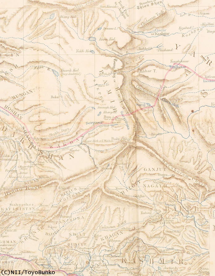
Located in the center of the Eurasia Continent, Central Asia geographically stands as a bridge between east and west. A region of tremendous extremes, Central Asia extends over a vast dry zone composed of the world’s largest mountains and most desolate deserts. Because of its incredibly challenging terrain, human settlements and trade routes were built between oasis towns just like drawing dot-to-dots on a line.


 |
| (14) |
Known as “the Roof of the World”, the Pamir Mountain range is made up of mountains with an average height of 3,500 to 4,500 meters (Map(12), Muztagh-Ata(13) of 7433 meters high). To the east of these mountains spreads the Tarīm Basin. In the middle of the basin is the Taklamakan Desert, with the Tian Shan Mountains(14) to the north, and the Kunlun Mountains(15) to the south. Oasis routes have long served travelers crossing these towering mountain ranges.
 |
| (15) |
Among these routes, the route running along the northern foothills of the Tianshan Mountains is called the Northern -Tianshan Circuit, while the one running along the southern foothills is called the Southern -Tianshan Circuit. This latter route then divides once again to skirt the the Taklamakan Desert, and these two routes north and south of the Taklamakan desert are the Northern and Southern Routes of the Silk Road. Most of the ruin sites lie along these two routes.

2. The Northern Route of the Silk Road
 |
| (16) |
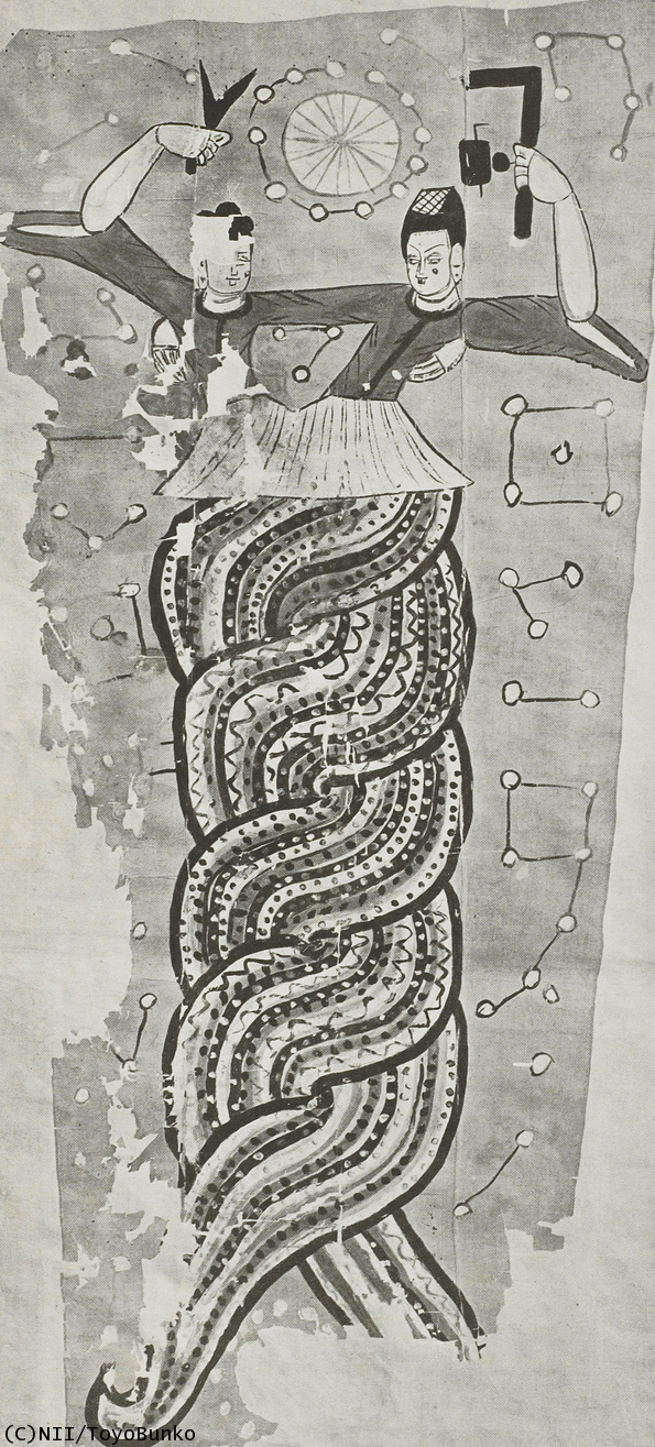
There are two population centers located on the Northern Route of the Silk Road: Turfan to the northeast (01) and Kucha in the center (04). Turfan, which is located in a bowl-shaped basin separate from the Tarīm Basin, has its lowest elevation at 154 meters below sea level. This area flourished not only as a strategic point on the North Route of the Silk Road, but also for its location at a significant transportation crossroads where one could travel along the Northern -Tianshan Circuit, or into Mongolia, and Dzungaria, all areas where nomadic peoples lived. The geographical proximity to China made it easy to bring Chinese culture into this area (Painted Image of Chinese Mythological Gods of Fuxi and Nvwa from Astāna Cemetery(16)). The later Cheshi Kingdom was located at Yār-khoto during the Early Han Period and then in later times, the city of Gaochang (Kara-Khōja) prospered in this area around Turfan
Kucha was situated almost in the center of the Northern Route and in former times was known as Qiuci (亀玆国). In 658, the Protectorate General of Anxi was established there, making Kucha an important base for trade in Central Asia. The notable Buddhist priest Kumārajīva (04 was from this area and introduced Mahayana Buddhism to East Asia during the Sixteenth Kingdoms Period.
3. The Southern Route of the Silk Road
The Southern Route is divided into Khōtan district (03) to the west and the Lop district (06) to the east. The most important oasis city on the Southern Route was the ancient Buddhist kingdom of Khōtan. The oasis city of Khōtan stood on a fertile plain sandwiched between the Yurungkash or White Jade River and the Karakash or Black Jade River, both rivers originating in the heights of the Kunlun Mountains. As suggested by their names, the rivers are well known for their quality jade which is found along the river beds. The jade produced in Khōtan was traded widely across the world from prehistoric times. It has been discovered from as far away as China in the east to Iran, Iraq and Egypt in the west. Located in proximity to India across the Karakorum Range, Khōtan had long been influenced by Indian Buddhist culture right down till the time it was conquered by the Karakhanid Dynasty in the early eleventh century. Dandān-Uiliq (03) are Buddhist ruins found to the northeast of Khōtan in the Taklamakan Desert.
 |  |
| (17) | (18) |
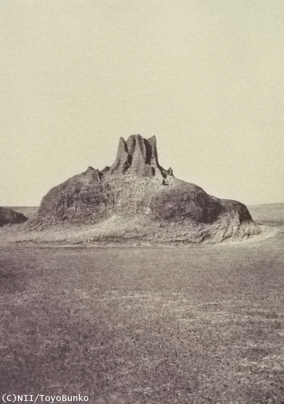
The Lop district located on the east part of the Route is famous for the ruins of Loulan (06) and Mīran (07). This district is also known as the Lop Desert. The “Wandering Lake,” Lop Nor, was once located in this area, and the landscape is characterized by its unusually-shaped hills calledMesas (small hills)(17) and Yardangs (table-like hills)(18) which were created by wind erosion so that only the hard layers remain. Because soil salt levels were so high, agricultural cultivatation was impossible in the area. According to the History of the Han, Loulan depended on neighboring countries for food even during its heyday.

4. Hexi Corridor
The Hexi Corridor is located in the northwestern part of China and is a historical route leading to the Tarīm Basin. The route is sandwiched between the Qilian Mountains, (a mountain range on the northern edge of the Tibetan Plateau), and the Gobi Desert (on the southeastern edge of Mongolia). Connecting China in the east with Central Asia in the west, the route was dotted with oasis towns and was a main artery for the east-west trade. From the very early days of the Silk Road during the Han DynastyHan Period, Chinese people began to colonize this area. Dunhuang (05) was the westernmost Chinese city at that time, and north of Dunhuang the remains of the Han-built section of the Great Wall still remains.
The Hexi Corridor now is part of Gansu Province. The origin of the province’s name comes from Ganzhou (present Zhangye) and Suzhou (present Jiuquan). From each province runs a river: the Ganzhou River (or Zhangye River) and the Beida River. Running north, both rivers flow into the Etsin-Gol River (or Juyan River). This area has long been a route for those traveling from Mongolia to the Hexi Corridor. At the end of the route on the side of Etsin-Gol, was the city of Juyan (09), which was established as a base for Chinese colonization during the Han Period. During the Western Xia Period, the city of Khara-Khoto (08) was established here as well.
Category: English
DepthReading
Key words: