遗产数据库
克孜勒卡拉Qizil qala(Kyzyl Kala)
Kyzyl-Kala
克孜勒·卡拉
克孜勒卡拉要塞位于古代花剌子模(今卡拉卡尔帕克斯坦)的历史区域,紧邻古城托普拉克卡拉。作为托普拉克卡拉防御体系的一部分,克孜勒卡拉起到了至关重要的额外防御作用。
作为古花拉子模建筑历史最后阶段的纪念碑,克孜勒卡拉(Kyzyl-Kala)体现了过渡性设计,这些设计后来影响了以巨大波纹柱为特征的阿夫里吉德时期城堡。
1938年,在著名考古学家S.P. Tolstov率领的呼罗珊探险队的一次探险中,发现了这座重要的建筑遗址。探险队对克孜勒卡拉进行了主要的研究和挖掘,发现这座堡垒虽然不大,但形状几乎呈方形。对地基和结构遗迹的调查显示,克孜勒卡拉周围环绕着双重围墙,每个角落都设有瞭望塔。
在聚落的核心地带,一条中央街道通向一座神庙,琐罗亚斯德教的祭司们在那里举行神圣的仪式,凸显了这座堡垒的宗教重要性。堡垒的住宅区被街道分隔成多个街区,每个街区都包含几间房间,供家庭居住。
克孜勒卡拉是古代花剌子模历史上贵霜-阿夫里吉德时期的一处独特建筑遗迹。它位于平原中央,这一战略位置使其成为哨兵,守护着附近的托普拉克卡拉要塞,该要塞常被视为古代花剌子模的瑰宝。传说中,托普拉克卡拉与克孜勒卡拉之间有一条地下通道相连,这一说法似乎合情合理,因为克孜勒卡拉作为花剌子模沙赫国的防御体系的一部分,一直运作至成吉思汗入侵。
这座堡垒的坚固结构和其战略位置凸显了其在保护该地区的防御网络中的重要性。克孜勒卡拉(Kyzyl-Kala)保存相对完好的状态,为我们提供了关于那个时代军事和住宅建筑的宝贵见解,反映了古代花剌子模人(Khorezmians)所采用的复杂城市规划和防御策略。
The Kyzyl-Kala fortress, situated in the historical region of Ancient Khorezm (present-day Karakalpakstan), stands near the ancient town of Toprak-Kala. Kyzyl-Kala, part of the fortified system of Toprak-Kala, served as a crucial additional defense structure.
As a monument from the last stage of antique Khorezm’s architectural history, Kyzyl-Kala exemplifies the transitional designs that would later influence the Afrigid period castles, characterized by their massive corrugated columns.
This significant architectural site was uncovered in 1938 during a Khorasan expedition led by renowned archaeologist S.P. Tolstov. The main studies and excavations of Kyzyl-Kala were carried out by the expedition team, revealing that the fortress, although not large, was almost square in shape. Investigations into the foundation and structural remnants showed that Kyzyl-Kala was surrounded by a double vallum and equipped with watchtowers at each corner.
At the heart of the settlement, a central street led to a temple where Zoroastrian priests conducted their sacred rites, emphasizing the religious importance of the fortress. The residential sections of the fortress were divided by streets into various blocks, each containing several rooms where families resided.
Kyzyl-Kala is a unique architectural relic from the Kushan-Afrigid period of ancient Khorezm’s history. Its strategic location in the middle of the plain served as a sentinel, safeguarding the nearby Toprak-Kala fortress, often considered the jewel of ancient Khorezm. Legend suggests that an underground passage connects Toprak-Kala and Kyzyl-Kala, a plausible notion given that Kyzyl-Kala continued to function until the invasion of Chengiz Khan, as part of the defensive system of the Khorezmshakh State.
The fortress’s robust construction and strategic placement underscore its importance in the defensive network protecting the region. Kyzyl-Kala’s relatively well-preserved state provides valuable insights into the military and residential architecture of the era, reflecting the sophisticated urban planning and defensive strategies employed by the ancient Khorezmians.
Qızıl qala (or Kyzyl Kala in Russian) is located about 25km due north of the centre of Biruniy City. To get there from Khiva drive through Urgench and cross the Amu Darya pontoon bridge linking Khorezm viloyati with Karakalpakstan. From the north bank check-point drive north for 2km and then cross the To'rtku'l road. Continue north for a further 1.6km and turn left onto the main highway for just 0.3km before turning right and continuing for a further 0.2km to the crossroad.
Turn left. From this point the road immediately bends to the right taking you in a northerly direction. After 1.4km you cross the main road and after 10.8km you take a left turn. From this point the road, which has houses on both sides, continues west for 2.9km before bending to the north. From now on measure your distances from this bend. Some 3.4km beyond the bend the landscape on the left of the road turns into desert. At 5.8km from the bend there is a right fork which leads to the entrance to the site of Kazakl'i-yatkan. Ignore this fork and continue driving north. Some 16.2km from the bend the road bends sharply to the right. You will soon see Qızıl qala set back from the road on the left hand side. After 17.9km the road crosses a canal. There is a track to the left which runs along the west side of the canal up to the fort.
|
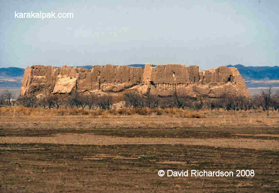
Some archaeologists have proposed that Qızıl qala was a military barracks garrisoned with troops, possibly linked with the nearby summer palace of Topraq qala just 3km to its east. However this seems questionable given its small size and its lavish interior decoration. It was more likely the fortified residence of an important Khorezmian aristocrat or official.
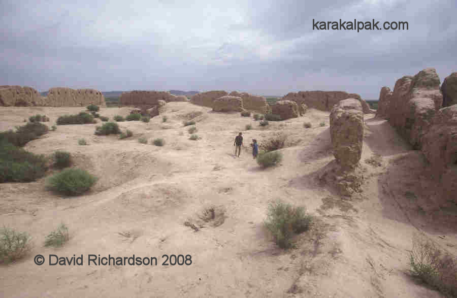
Qızıl qala remained largely unexplored until it was excavated by Dr G'ayratdiyin Xojaniyazov and other members of the Karakalpak Branch of the Uzbek Academy of Sciences in the 1980s.
|

|

Image courtesy of Associate Professor Alison Betts, University of Sydney Central Asian Programme.
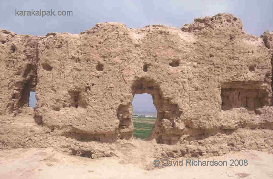
The fortress is situated on the flat plain just south of the Sultan Uvays Dag mountains and seems to have been constructed on a slightly raised platform. It is still in relatively good condition on the outside and is almost square, measuring just 65 by 63 metres, with its corners orientated towards the cardinal points. The curtain walls are up to 16 metres high and on three of the four sides consist of parallel external and internal walls separated by a two-metre wide corridor. The external wall contains two rows of regularly spaced arrow-shaped loopholes that were presumably accessed from separate galleries.
|
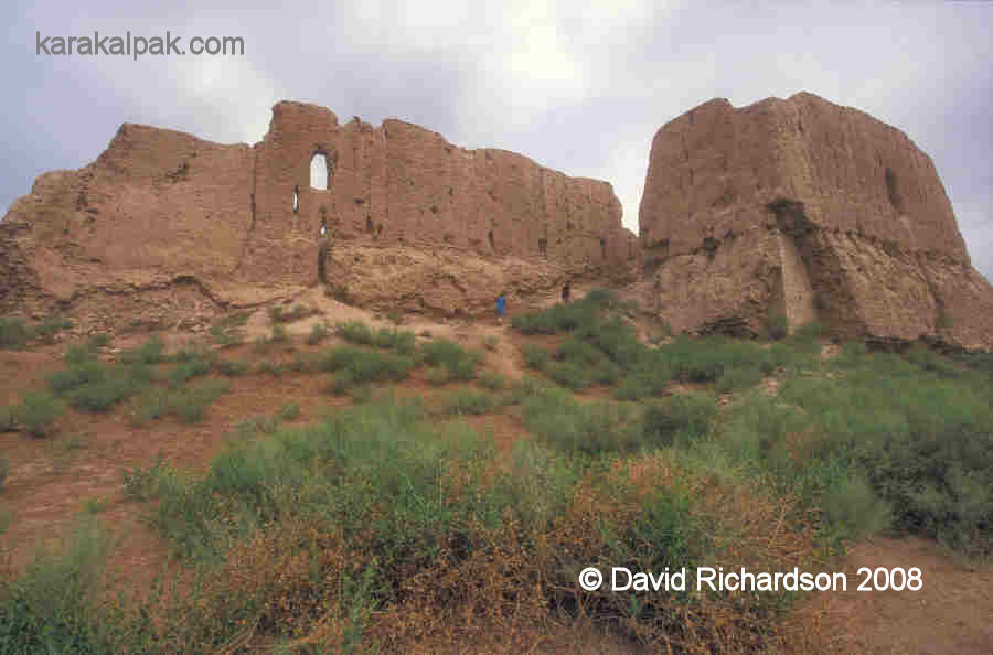
There is just one entrance, located in the middle of the south-east wall. This was accessed by means of a protruding rectangular barbican with a gate in its south-western side. The entry ramp to this gate slopes upwards alongside the main curtain wall of the fort, where it could have been covered by defending archers.
|
|
|
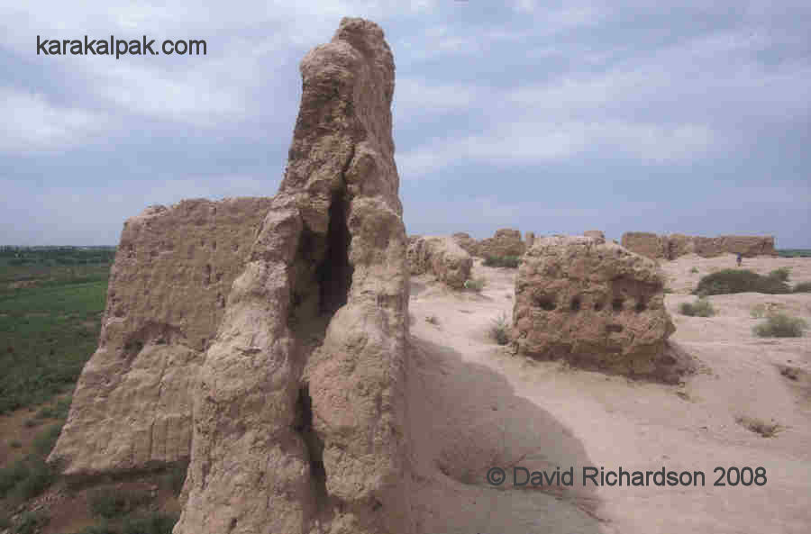
In addition there are two large protruding rectangular towers positioned in the middle of the north-west and south-west walls. These contained pairs of rectangular rooms. Rooms were also discovered within the interior of the fortress. In addition to the normal ceramics, glass, stoneware and fragments of bronze, the excavations also uncovered remains of wall frescoes, suggesting that it was occupied by a high-status individual and his retinue.
The fort was built in the 1st or 2nd centuries AD and is therefore contemporary with Topraq qala. It was occupied until the 4th century and then abandoned. It seems to have been restored much later, during the 12th or early 13th century, just prior to the Mongol invasion.
Google Earth Coordinates
The following reference point (in degrees and digital minutes) will enable you to locate Qızıl qala on Google Earth.| Google Earth Coordinates | ||
|---|---|---|
| Place | Latitude North | Longitude East |
| Qızıl qala | 41o 55.807 | 60o 47.050 |
Note that these are not GPS measurements taken on the ground.