遗产数据库
Kazakl'i-yatkan
 Identity
Over the past decade the appellation Kazakl'i-yatkan has become the most commonly used name for this site in both the archaeological literature and the popular media. Kazakl'i-yatkan is an English transliteration of Казаклы-яткан, the simplified Russian form of its local Karakalpak name - Қазақлы-яткан in Cyrillic or Qazaqlı-yatqan in Latin. The literal meaning of the name is "Qazaqs are lying down". The term dates from the early 1930's when the area was occupied by exhausted Qazaqs who had fled south from the chaos and starvation engulfing western Kazakhstan following Stalin's enforced collectivization.
|
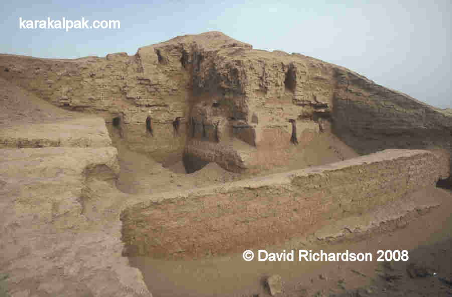
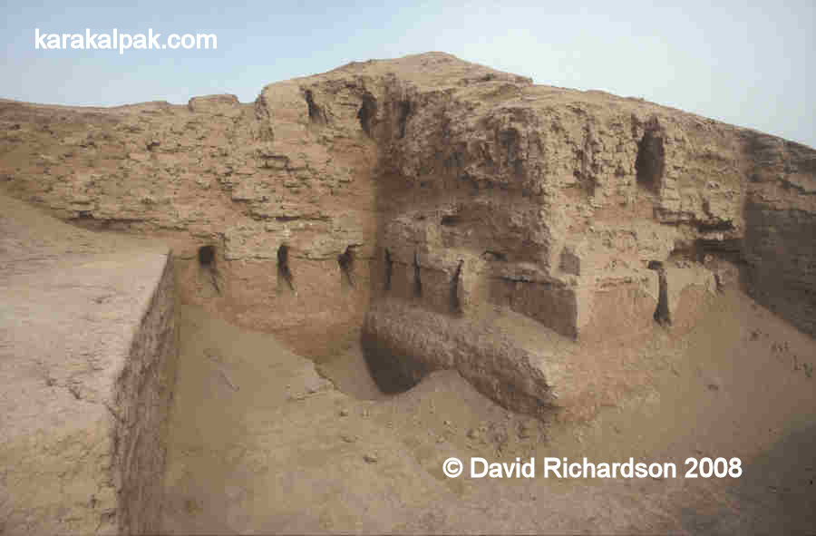
The corner tower and outer wall of the citadel of Kazakl'i-yatkan in 2003, following
their excavation by the Karakalpak-Australian Archaeological Expedition in 1999 and 2000.
Prior to this time the site was known by the local Karakalpaks as Ақша Хан Қала or Axsha Xan Qala, transliterated to Akcha Khan Kala or Akhcha Khan Kala from the Russian. The name is derived from a legendary leader of the same name.
Location
Kazakl'i-yatkan is just over 15km north of Biruniy city centre and 13km south of the escarpment of the Sultan Uvays Dag.It lies in the north-western part of what archaeologists now call the Tash-k'irman oasis, a former agricultural region that was once watered by a northern arm of the Akcha Darya. This outlet of the Amu Darya seems to have finally ceased its natural flow in the early centuries of the 1st millennium. All that remains today is an extensive region of sandy desert and lakes known as the Aq Qum Sands, which extends for about 30km in a north-easterly direction starting from the south-east of Biruniy. The most northern part of this strip of desert is known as the Daganıoldı Sands, and this is the location of Kazakl'i-yatkan (Axsha Xan Qala). The sands, which come from the ancient bed of the Akcha Darya, have not only concealed the site but have preserved it for posterity. The largest lake in the region, which forms the northern boundary to the Aq Qum Sands, is still known as Akcha Ko'l.
Although the site is still being actively investigated, visitors are welcome but are requested to contact the site caretaker on arrival. The main annual excavation season is from September to early October. Beware that some of the excavations from previous seasons have been reburied to protect the monument from erosion.
It takes just under two hours to reach the site from Khiva. First drive through Urgench and cross the Amu Darya pontoon bridge linking the viloyat of Khorezm with Karakalpakstan. From the north bank check-point drive north for 2km and then cross the To'rtku'l road. Continue north for a further 1.6km and turn left onto the main highway for just 0.3km before turning right and continuing for a further 0.2km to the crossroad.
Turn left. From this point the road immediately bends to the right taking you in a northerly direction. After 1.4km you cross the main road and after 10.8km you take a left turn. The road, which has houses on both sides, continues west for 2.9km before bending to the north. From now on measure your distances from this bend. Some 3.4km beyond the bend the landscape on the left of the road turns into desert. At 5.8km from the bend there is a right fork which after 300 metres leads to the entrance to the site of Kazakl'i-yatkan on the right hand side. There are two buildings on either side of the entrance, the caretaker's house on the right and the archaeologists' dormitory on the left. After reporting to the caretaker you can walk south across the desert to reach the partially buried site.
|
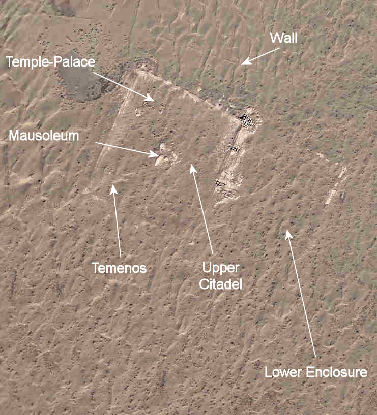
The caretaker's bungalow lies to the north of the site. Image courtesy of Google Earth.
Alternatively you can reach the site from No'kis. It is only 115km as the crow flies but it takes 136km or about two hours by road. Leave No'kis on the A380 highway to Biruniy. After 93km from No'kis the road passes the turn to the Badai Tugai Reserve on the right and after 109km it bends to the right and then heads south from the mountains towards Biruniy. Just after Kalenderkhana, some 6½km from the last bend and 116km from No'kis, take the left turn. In less than 10km this side road reaches a t-junction. Turn right. After a further 9½km there is a small left turn, just as the landscape turns to desert. The entrance to Kazakl'i-yatkan is just 300 metres on the left.