Janbas-Kala是卡拉卡尔帕克斯坦的一个古老聚落,其历史可追溯至古代花剌子模(Khorezm)的“千城”时代。这一时代分为康居(Kanguy)和贵霜(Kushan)两个阶段,分别以花剌子模所属的国家命名。Janbas-Kala的建立可追溯至康居第一阶段,S.P. Tolstov将其建立日期确定为公元前4世纪至公元1世纪之间。
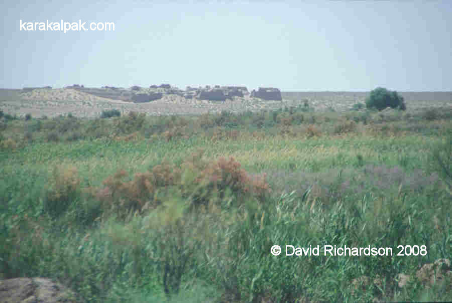
扬巴斯-卡拉(Janbas-Kala)位于一片从西北延伸至东南的沙漠平原的西北坡,在“古代灌溉之地”中东北方向位置突出。它阻挡了从苏尔塔努伊兹达格(Sultanuizdag)向东南延伸的一连串山丘,这一描述详见S.P.托尔斯托夫(S.P. Tolstov)在其著作《古代花剌子模》(Ancient Khorezm)中的描述
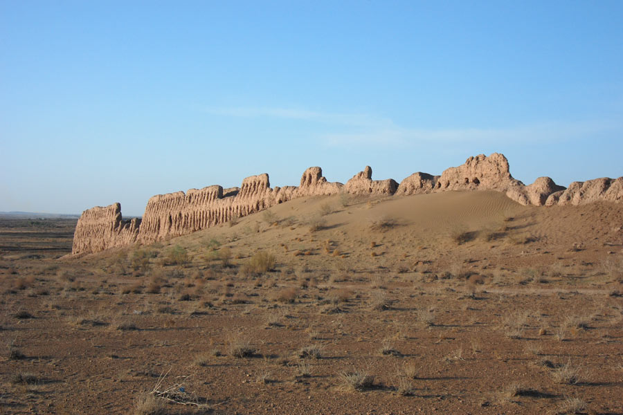
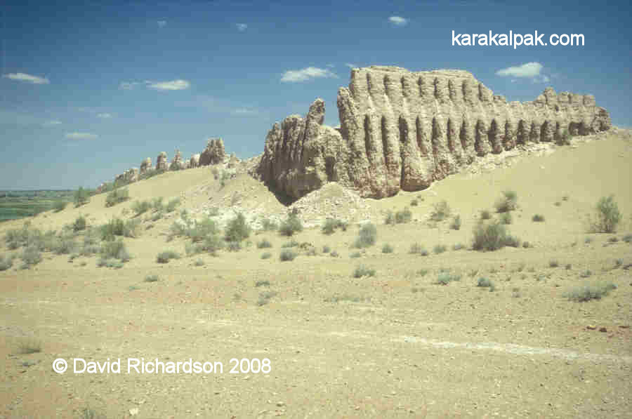
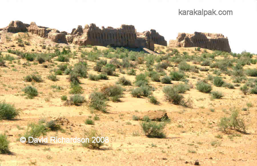
这座堡垒是一座保存完好的三角形建筑,长约200米,宽约170米,朝向四个基本方位。它的保存完好得益于数百年间沙丘的堆积,这些沙丘有助于保护堡垒的墙壁。这些墙壁高达近10米,彰显了这座建筑的宏伟规模。外墙后面还有一道加固主防御工事的墙。外墙底部较厚,宽1.30米,而内墙宽约1米。外墙上的狭窄枪眼表明了这座堡垒的军事用途。
在东方堡垒中,詹巴斯-卡拉堡(Janbas-Kala)独具特色,它没有角楼。另一个显著特点是其大门前的保留结构,这使得守军能够迫使入侵者进入狭窄的走廊,并从上方发起攻击。这一战略设计凸显了该堡垒的巧妙防御设计。
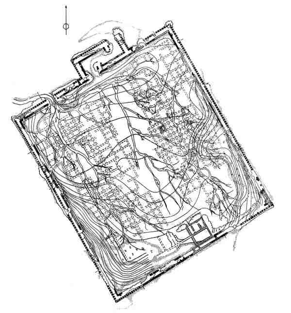
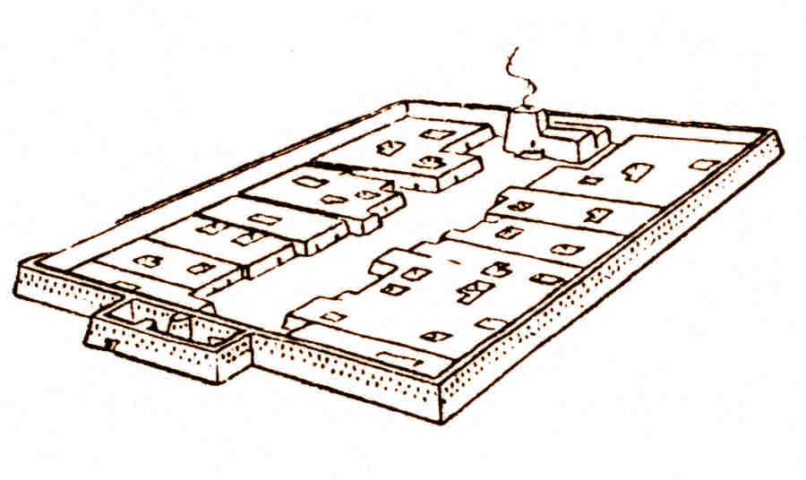
内部结构上,Janbas-Kala的布局相对简单明了。从大门开始,一条主要的城市街道从西北延伸至东南,通向南门附近的一座大型建筑。街道两侧是住宅区,每个住宅区被分隔成众多房间,每个住宅区大约有150间房间。考古学家认为,南门建筑曾是拜火教徒的圣地,被称为“火之屋”。这一理论得到了圣地角落房间中发现的灰烬残留物的支持。
几个世纪以来,詹巴斯-卡拉的居民成功击退了游牧民族的入侵。然而,在公元1世纪,入侵者使用攻城槌成功攻破了堡垒坚固的大门,并在大门以西的城墙处略微突破。箭镞等考古证据表明,堡垒内部发生了一场激烈的战斗。大多数居民可能被杀害,幸存者则被俘虏。这次袭击后,堡垒再也没有得到修复,并在接下来的2000年里逐渐因自然因素而坍塌。如今,只有巨大的城墙依然屹立,见证着它昔日的辉煌。
Janbas-Kala is an ancient settlement in Karakalpakstan, dating back to the antiquity of Ancient Khorezm during the period known as the “thousand cities” era. This era is divided into the Kanguy and Kushan stages, named after the states to which Khorezm belonged. The foundation of Janbas-Kala is attributed to the first Kanguy stage, with the date of its establishment determined by S.P. Tolstov to be between the 4th century BC and the 1st century AD.
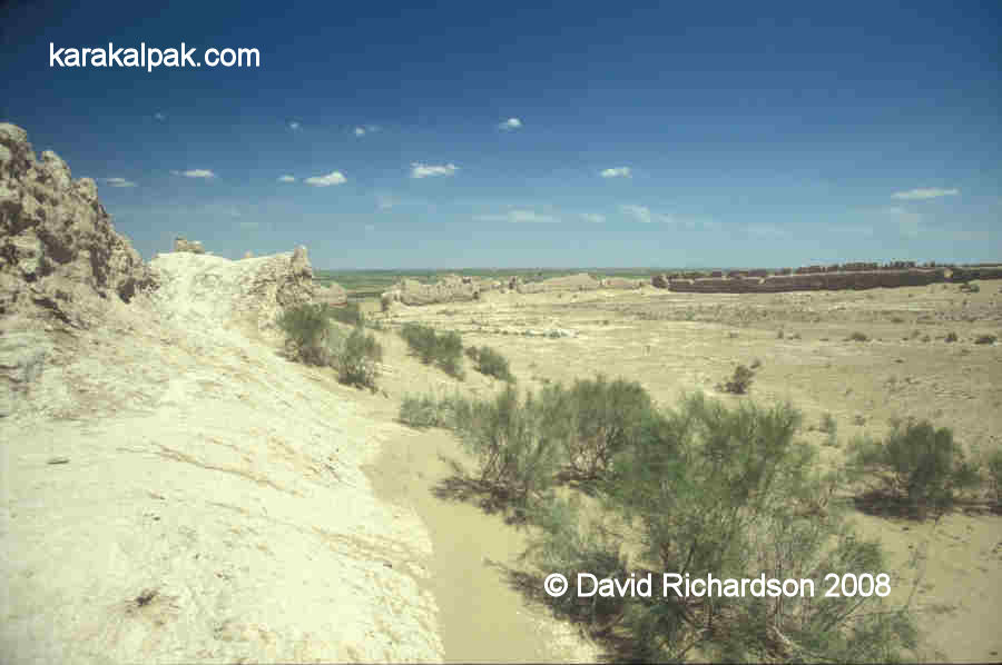
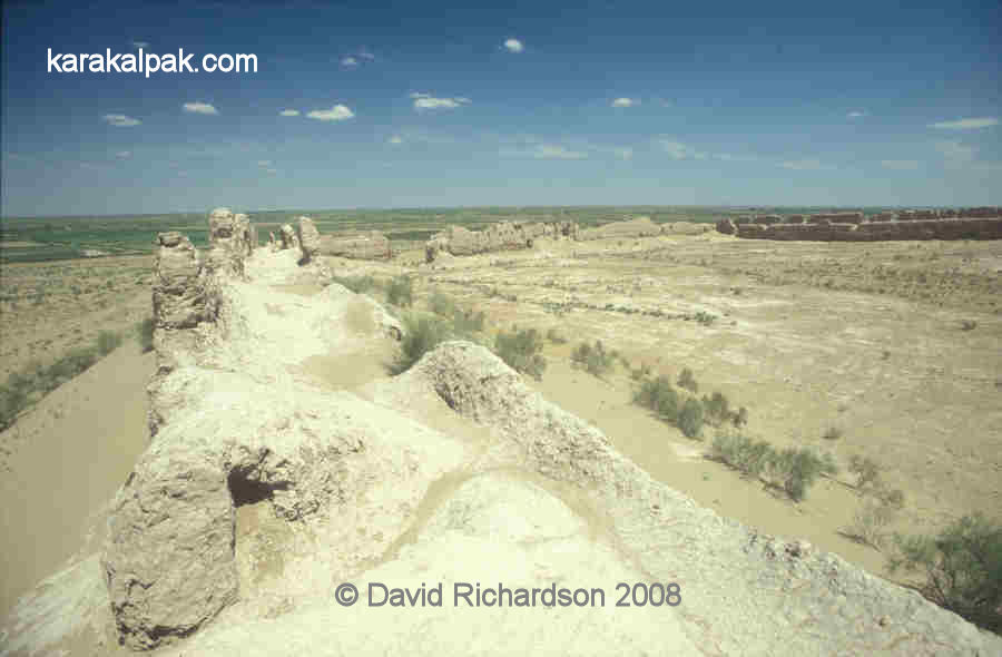
Situated on the northern-western slope of a desert flat elevation extending from the northwest to the southeast, Janbas-Kala is prominently located northeastward in the “Lands of Ancient Irrigation.” It locks a chain of hills stretching to the southeast from Sultanuizdag, as detailed by S.P. Tolstov in his work “Ancient Khorezm.”
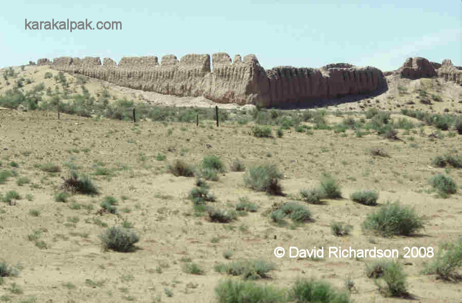
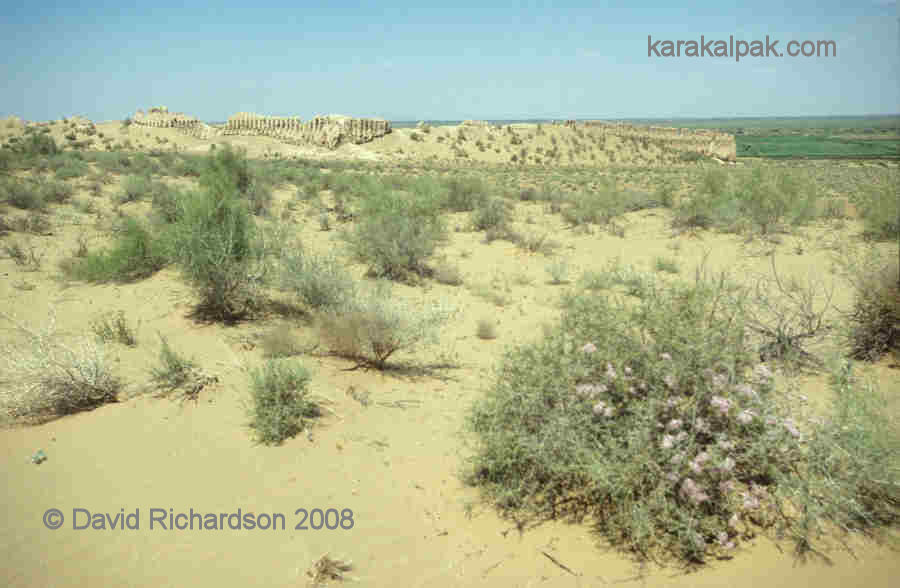
The fortress is a well-preserved triangular structure, measuring approximately 200 by 170 meters, oriented to the cardinal directions. Its preservation can be attributed to the centuries-long accumulation of sand drifts, which have helped protect the fortress walls. These walls stand almost 10 meters high, signifying the building’s immense scale. Behind the outer wall lies an additional wall, reinforcing the main fortification. The outer wall, which thickens toward the bottom, measures 1.30 meters wide, while the inner wall is about 1 meter wide. The narrow embrasures in the outer walls indicate the fortress’s military purpose.
Unique among Eastern fortresses, Janbas-Kala lacks corner towers. Another distinguishing feature is the preserved structure in front of its gates, which allowed defenders to force invaders into a narrow corridor and attack them from above. This strategic design highlights the fortress’s defensive ingenuity.
Inside, Janbas-Kala’s layout is relatively straightforward. From the gates, a main city street extends from the northwest to the southeast, leading to a large building near the southern gates. Residential blocks line both sides of the street, each divided into numerous rooms, with approximately 150 rooms per block. The southern gate building is believed by archaeologists to have been a sanctuary for fire-worshippers, known as the “House of Fire.” This theory is supported by the discovery of ash residues in a corner room of the sanctuary.
For centuries, Janbas-Kala’s inhabitants successfully repelled nomadic incursions. However, in the 1st century AD, invaders managed to breach the fortress’s formidable gates using a battering ram, breaking through the wall slightly west of the gate. Archaeological evidence, such as arrowheads, indicates a fierce battle ensued inside the fortress. Most residents were likely killed, and survivors taken captive. Following this attack, the fortress was never restored and gradually succumbed to the elements over the next 2,000 years. Today, only the massive walls remain as a testament to its former grandeur.
Location
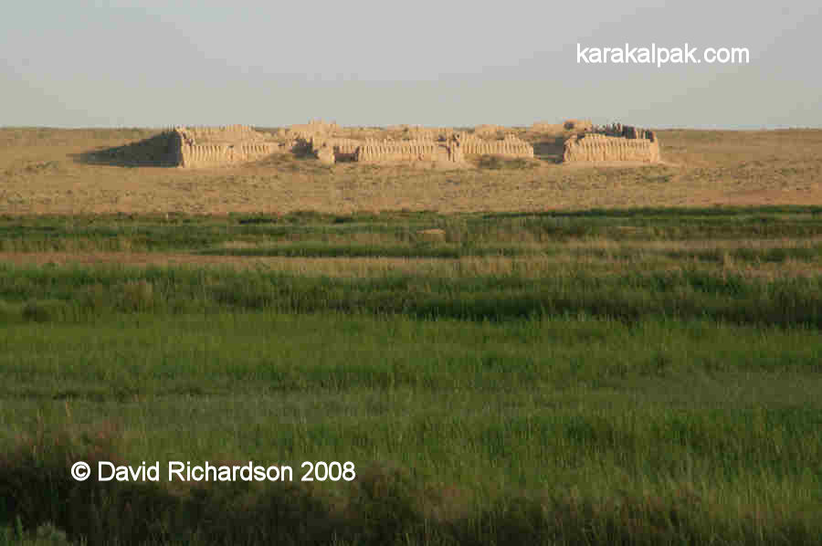
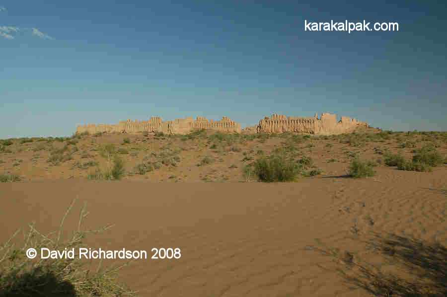
Janbas or Jambas qala in Karakalpak, or Dzhanbas Kala in its Russian transliteration, is about 47km north east of To'rtku'l in the To'rtku'l tuman of Karakalpakstan.View of Janbas qala from the road.
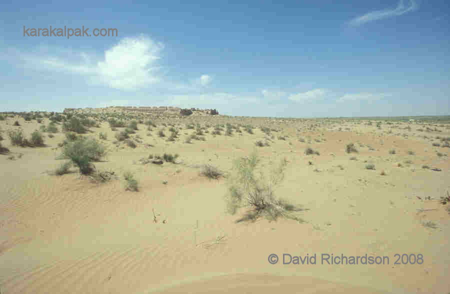
It is located in a remote region on the last of a chain of low hills that stretch out to the east from the Sultan Uvays Dag. It is dramatically positioned on the side of a low ridge overlooking the plain below. The region surrounding the fort is now fairly barren desert, but the valley below the fort is currently irrigated and was once watered by an eastern branch of the southern Akcha Darya delta.
Entrance to Janbas qala.
In our opinion Janbas qala is one of the "must-see" qalas of Ancient Khorezm.
Excavations
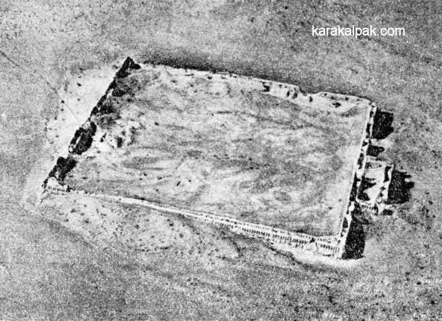
Janbas qala was one of the earliest monuments to be excavated directly by Sergey Tolstov and other members of the early Khorezm Archaeological Expedition. It was investigated in 1938.Plan of Janbas qala. From Sergey Tolstov's "Ancient Khorezm", 1948.
Aerial photograph of Janbas qala.
From Sergey Tolstov's "Following the Tracks of Ancient Khorezmian Civilization", 1948.
Aerial photography of the site took place between 1946 and 1948. The walled city is oriented with its corners facing the four cardinal points. It slopes down toward the north-west.
Janbas qala
In Karakalpak janbas and jambas are both words for side or flank, spoken in different regional dialects. Janbas qala is therefore the citadel on the side or flank of the hill. It remains a mystery to us why it was built on the side of the hill and not on the more strategic high point of the ridge.Janbas qala - the citadel on the flank of the hill.
It is possible that Janbas qala was one of the earliest frontier fortresses in Khorezm, built on the very edge of its eastern border after the province gained its independence from the Persian Achaemenid Empire, possibly in the early 4th century BC. During its occupation it was surrounded by many small agricultural settlements and field and irrigation systems.
Today Janbas qala is surrounded by desert. Yet it still overlooks the modern oasis below.
Janbas qala has one of the most archaic fortification systems dating from that Early Antique period, with a slightly irregular rectangular layout – 200 metres long by 170 metres wide. All four of its flanking walls are in relatively good condition, reaching in places up to 20 metres in height.
The impressively high walls of Janbas qala on its southernmost corner.
The double walls contained two archers' galleries, one above the other, with two tiers of closely spaced loopholes penetrating the outer wall. It is likely that the walls had an uncovered third storey archers' gallery since the top of the walls were castellated. The citadel had a single entrance located in the middle of the north-west facing wall. It was protected by a rectangular labyrinth gateway, with visitors forced to turn right into a heavily defended courtyard before gaining entry into the citadel. Here they could be inspected prior to admission while being covered by defending archers, especially on their left undefended side.
Janbas qala from the northernmost corner showing the rectangular entrance gate.
View of the eastern corner of Janbas qala.
Unlike contemporary Ayaz qala 1, however, Janbas qala has no towers to defend its flanks. This meant that the fort was potentially vulnerable from an attack on the lower sections of its walls. The military architects had attempted to overcome this design weakness by including some steeply inclined loopholes so that some archers could fire down along the face of the walls. Tolstov believed that this design of loophole could be traced back to the time of the Assyrians. It was subsequently used in Persia by the Achaemenids and later by the Parthians but then seems to have become obsolete.
Certainly the design never caught on in Khorezm - all of the other frontier fortresses were constructed with defensive towers instead.
View of the south and western flanks of Janbas qala covered with wind-blown sand.
Most of the normal embrasures were oriented at a right angle to the wall, only permitting forward fire. However after every 20 or 30 normal loopholes there was a set of three special loopholes accessed by the archer from a small round-arched niche, set into the outer wall. One loophole faced forward, one was angled to the right and a third angled to the left. There were also pairs of angled embrasures at each corner of the citadel. Given the enormous number of fortress loopholes – over one thousand - the citadel must have been manned by a large number of defenders. As the total population was likely to have been no more than 2,000, it is possible that the defenders included women as well as men. It was of course a tradition in many of the nomadic societies of that time for both sexes to be trained in military skills from an early age.
Interior of Janbas qala, looking towards the north.
The interior of Janbas qala was completely filled with residential buildings. These were arranged in the form of two separate blocks of communal housing, located on either side of a wide central main street. Each block contained some 150 to 200 rooms and could therefore accommodate some 500 to 1000 persons. Tolstov found that the tamg'as or symbols scratched onto the mud bricks used to build these residential blocks were different. One block had one common symbol and the other block had a different common symbol.
Schematic layout of the interior of Janbas qala. From Tolstov.
Tolstov somewhat fancifully interpreted this to imply that the citadel had been occupied by the two separate wings or divisions of a single tribe.
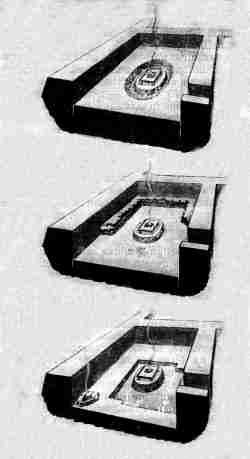
Another feature of Janbas qala was the location of a monumental building at the far end of the main street from the entrance. This was excavated by Tolstov in 1939. It contained an oval pedestal with the remains of ashes and was assumed to be the remains of the city's main fire temple.
Tolstov's alternative interpretations of the fire altar at Janbas qala.
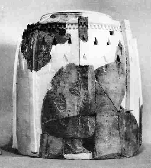
During much later excavations in the 1960's archaeologists discovered a collection of ossuarys dating back to the 1st century AD on the outskirts of Janbas qala from what may have been a local necropolis. Made of baked clay, the ossuarys were in a wide range of styles, including a woman sitting on a throne, a horse-rider, and several shaped like toy fortresses with loopholes and towers.
Fort-like ossuary from Janbas qala.
Excavations within Janbas qala revealed a rich selection of finds, including ceramics, terracotta statuettes, metal ware, bracelets, signet-rings, jade and large numbers of glass beads that may have been imported from the northern Black Sea region. All this evidence indicated that Janbas qala was only occupied from the 4th century BC up until the 1st century AD. The absence of any finds of coinage shows that it had already been abandoned by the 2nd century AD.
From the large number of finds of metal arrow heads inside the town, Tolstov concluded that the citadel must have been overwhelmed by nomads in the 1st century AD. He conjectured that the wall to the south of the entrance gate had been breached by battering ram and that this had been followed by a fierce internal fire fight as the attackers engaged the defenders within the citadel.
An alternative possibility is that the town might have been abandoned because of a failure in the local water supply. We know that in the 2nd century AD, during the early Kushan period, the Amu Darya began flowing back into the Caspian via the Uzboy, reducing the outflow through the Akcha Darya. Conversely we know that other settlements on the Akcha Darya were from time to time badly affected by flooding. It is clear from the chemistry of the clay at Janbas qala that part of the site was once flooded. In time we may get a better understanding of what brought the occupation of Janbas qala to an end.
 |
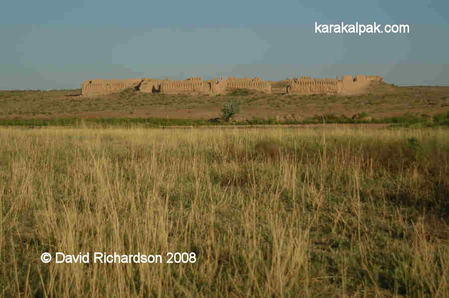 |
Views of Janbas qala just before sunset.
Google Earth Coordinates
Unfortunately the region of Janbas qala is only covered by low resolution satellite imagery on Google Earth. Its approximate position is as follows:| | Google Earth Coordinates |
|---|
| Place | Latitude North | Longitude East |
|---|
| Janbas qala | 41o 51.480 | 61o 18.245 |
| | | |
Note that these are not GPS measurements taken on the ground.