遗产数据库
Gyaur qala
卡拉卡尔帕克斯坦久卡拉
吉亚尔-卡拉,意为“异教徒的堡垒”,是卡拉卡尔帕克斯坦的一处古老聚落,其历史可追溯至公元前4世纪左右。这座堡垒拥有高达十米的坚固城墙,内部包含两座重要城堡的遗址,据信曾分别作为神庙和宫殿使用。该遗址的历史和建筑宏伟,让人得以一窥古代花剌子模丰富的文化画卷。
第一座城堡被推测既是防护建筑,也是神庙,反映了当时的精神和防御需求。该地区具有历史意义,因为它是《迦特》的诞生地,《迦特》是《阿维斯塔》中最古老的文本,由先知查拉图斯特拉(琐罗亚斯德)撰写。在吉奥尔-卡拉发掘的遗址和文物证明,其居民是琐罗亚斯德教徒,他们高度重视拜火仪式,这是他们宗教的核心教义。
第二座城堡似乎曾是总督的宫殿,拥有一个庭院、众多附属建筑和装饰着雕刻与绘画的居住区。考古发掘揭示了各种奢侈品,如各种饰品、绣有金线的织物,以及其他表明精英阶层曾在此居住的文物。这些文物生动地展现了堡垒居民的富裕与精致生活。
居尔卡拉(Gyaur-Kala)位于贸易路线十字路口的战略要地,得益于附近的大丝绸之路北线,因此相较于花剌子模的其他古代要塞,其存在时间更长。繁忙的贸易路线促进了经济繁荣和文化交流,使居尔卡拉成为该地区的重要枢纽。
这座堡垒的名字源于8世纪初征服它的阿拉伯人。吉奥尔-卡拉的居民曾激烈抵抗阿拉伯征服者长达半个多世纪,由于居民信奉琐罗亚斯德教,征服者便将其命名为“异教徒堡垒”。尽管最终被阿拉伯人攻陷,但这座堡垒一直运作到1220年蒙古人到来时才停止。成吉思汗的长子乔奇下令彻底摧毁这座城市,导致其最终被遗弃。
然而,吉奥尔-卡拉的遗产并未随着它的毁灭而终结。顽强不屈的居民们在附近建立了一个新的定居点,继续传承他们的遗产和传统。
参观吉奥尔-卡拉(Gyaur-Kala)能让人仿佛穿越时空,目睹一个曾因贸易、宗教和治理而繁荣的文明的辉煌。这座曾经辉煌的堡垒的遗迹,令人深切地感受到中亚丰富历史中权力、文化和宗教不断变化的动态。
Gyaur-Kala, translating to “The Fortress of Infidels,” is an ancient settlement in Karakalpakstan, dating back to approximately the 4th century BC. This fortress, with its formidable ten-meter-high walls, encapsulates the ruins of two significant citadels, believed to have served as a temple and palace structures. The site’s historical and architectural grandeur offers a glimpse into the rich cultural tapestry of ancient Khorezm.
The first citadel is presumed to have been both a protective structure and a temple, reflecting the spiritual and defensive needs of the time. This region is historically significant as the birthplace of the Gathas, the most ancient texts of the Avesta, composed by the prophet Zarathustra (Zoroaster). The ruins and artifacts unearthed in Gyaur-Kala provide evidence that its inhabitants were Zoroastrians, who held fire worship in high regard, a central tenet of their religion.
The second citadel appears to have been the governor’s palace, featuring a courtyard, numerous household outbuildings, and living quarters adorned with carvings and paintings. Archaeological excavations have revealed luxury items such as various ornaments, fabrics embroidered with gold, and other artifacts indicating that the elite class resided here. These relics paint a vivid picture of the opulence and sophistication of the fortress’s inhabitants.
Location
Gyaur qala is situated 63km from Biruniy and 81km from No'kis. It is located just 80 metres from the right bank of the Amu Darya and 1.5km west of the Sultan Uvays Dag mountains. It falls within the Qarao'zek tuman of Karakalpakstan.To avoid confusion with the Gyaur qala fort at Mizdahkan it is sometimes clumsily referred to as Gyaur qala Sultan Uvays Dag.
To reach the site from Biruniy, leave the city on the A380 heading for No'kis. The road turns towards the north after leaving the Biruniy urban area, heading for the mountains. After 34km, close to the mountains, the direction of the road turns towards the east and after 50.5km it reaches the left turn for the Badai Tugai Reserve.
 |
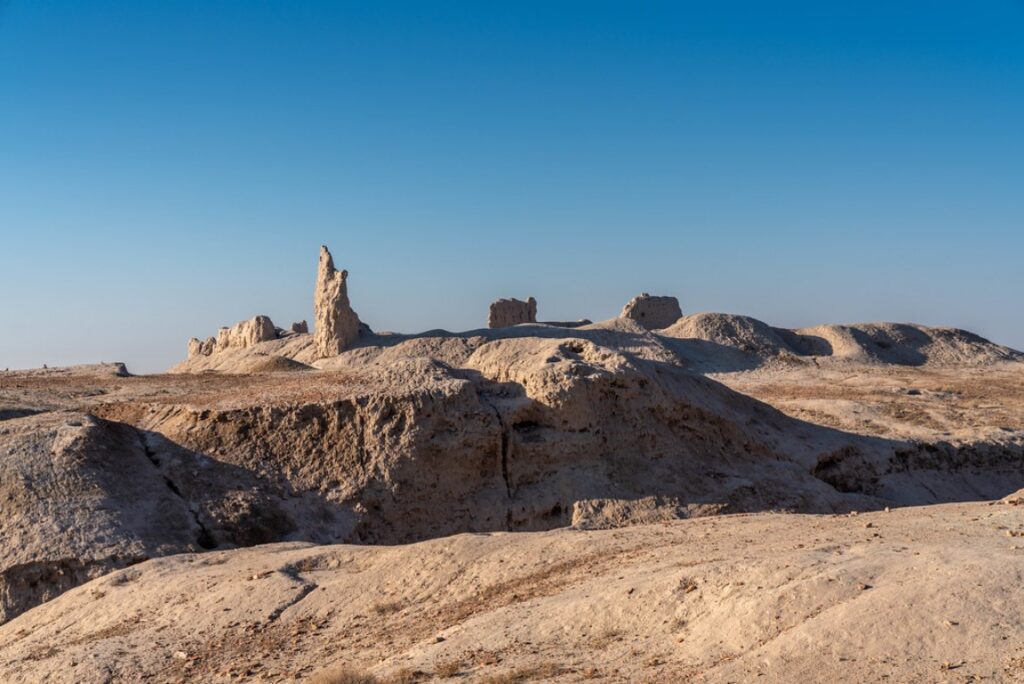
Panorama of the remains of Gyaur qala next to the Amu Darya.
From this point, the road continues straight for a further 4.25km and then bends right, heading due north. After 12.3km from the Badai Tugai junction there is a metalled side road on the left. Continue along this side road avoiding any further side turns. Some 7.6km from the A380 the road kinks right and then left before reaching an industrial site. Turn right at the buildings and after a further 1km the ruins of Gyaur qala can be clearly seen on the left hand side.
Excavations
Gyaur qala was initially investigated briefly by Sergey Tolstov in 1940. More detailed excavations were undertaken by Yuri Rapoport and S. A. Trudnovskaya in 1952. The Soviet authorities were considering plans to build a hydro-electric plant close to the site and so the Khorezm Expedition was allocated a detachment of prison labourers to speed up the work. Rapoport and Trudnovskaya's findings were published in Volume 2 of the Works of the Khorezm Archaeological-Ethnographical Expedition in 1958.Gyaur qala
The name Gyaur qala probably originates from the time of the Arabs who referred to all non-Muslims as "geburr". Over time the word became pronounced "gyaur".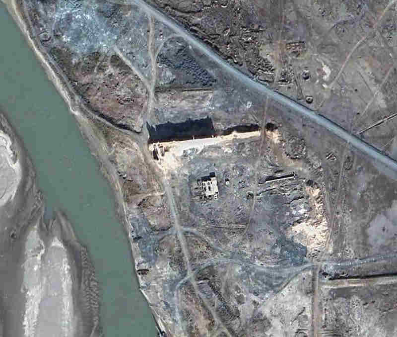 |
Satellite image of Gyaur qala. Image courtesy of Google Earth.
The buildings just to the south of the wall are modern.
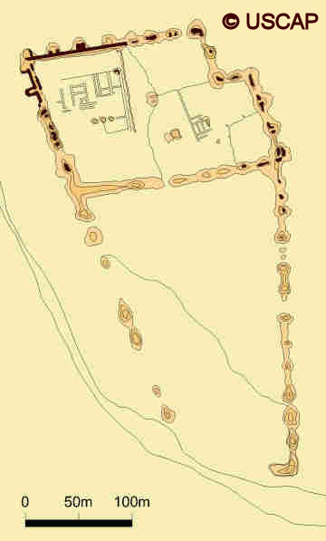 |
Schematic plan of Gyaur qala.
Image courtesy of Associate Professor Alison Betts, University of Sydney Central Asian Programme.
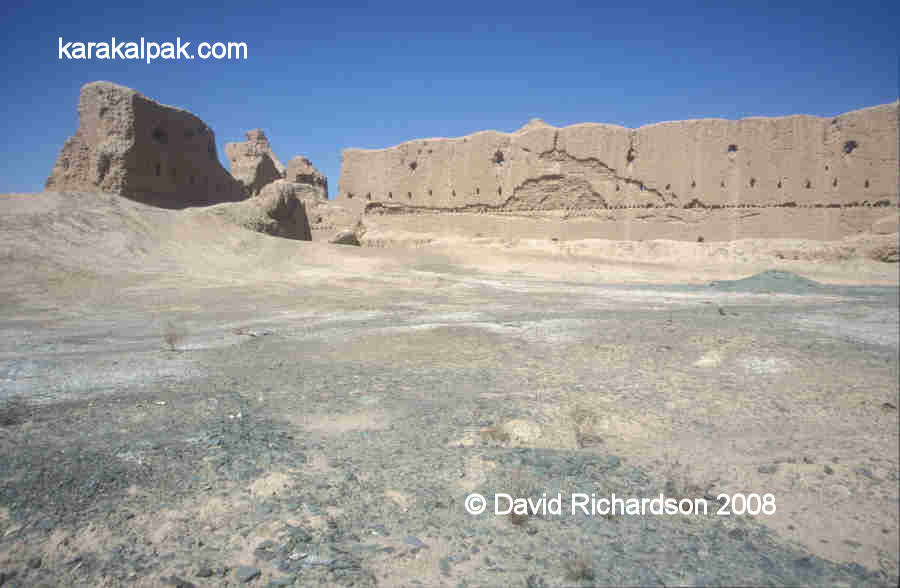
Gyaur qala was a big fort and had an unusual trapezoidal layout. It measured roughly 450 metres from north to south and was roughly 200 metres wide at the northern end. The site then progressively narrowed to the south, the south-western wall appearing to curve to follow the bank of the river. Today only the northern wall and part of the north-west corner remains. Even so, the northern wall is preserved in parts up to 15 metres high.
 |
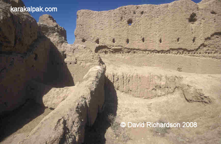 |
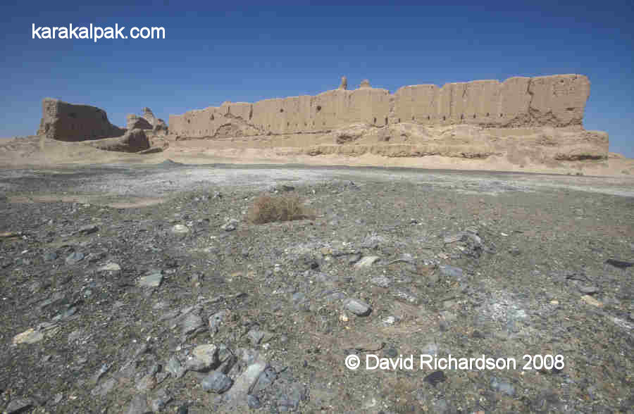
Two views of the north-western corner of the ruins, taken from inside the northern courtyard.
Note the embrasures and the holes for holding the wooden floor beams of the archers' gallery in the bottom picture.
The fort was enclosed with a double mud-brick wall built upon a plinth or socle of compacted clay or paqsa, designed to defend the lower section of the wall against attack by battering ram. The outer walls contained two tiers of embrasures, the space between the walls being vaulted to support the upper archers' gallery. The upper archers' gallery was roofed with wooden beams, reeds and clay. At the very top of the wall was an open topped gallery, protected by battlements. The walls were reinforced with towers along each flank and at each corner, the corner towers arranged in the early "dove-tail" pattern. The towers had three storeys aligned with the levels within the walls.
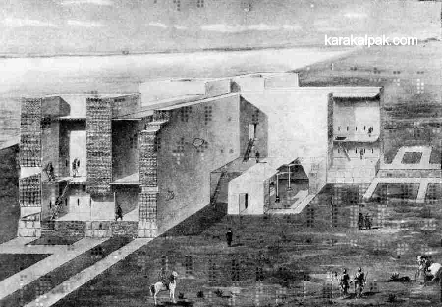 |
Illustration showing the structure of the outer walls and one of the western side towers.
Reconstruction by Yu. A Rapoport and G. S. Kostina.
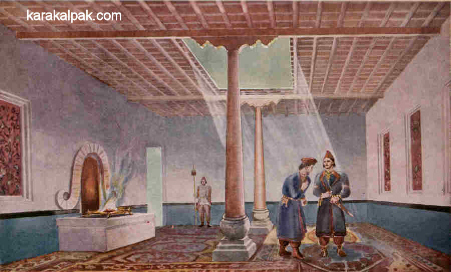
The space enclosed by the outer walls was separated into two large courtyards by a dividing wall. The southern enclosure was devoid of buildings and may have been used for billeting mounted troops or for containing temporary dwellings such as yurts. However the northern enclosure contained a monumental building in its north-western corner. This contained a "guest hall", richly decorated with wall paintings and clay statues. It was enclosed by a roof supported by wooden columns standing on carved stone pedestals. One of the walls contained what appeared to be the remains of a fire altar with a prominent decorative ram's horn surround behind it.
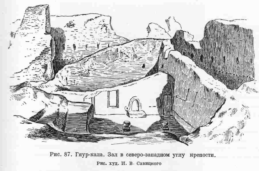 |
Sketch of the excavations of the "guest hall" showing the ram's horn decoration at the back of the fire.
Drawn I. V. Savitsky. Note the stone column bases.
 |
Imaginary reconstruction of the guest hall.
Painting by Yu. A. Rapoport and G. S. Kostina.
The fort appears to have been constructed during the 4th century BC. Its objective was to guard and control the important Amu Darya trade route at it crossed the southern frontier of Khorezm. It must have been an impressive site when viewed by vessels sailing down the Amu Darya. There is ample evidence to show that Khorezm was at that time an important stage on a trade route that extended from India in the east, to the Black Sea in the west, and to Persia and Mesopotamia in the south-west. The fort continued in use until the late Kushan period, around the 3rd century AD, during which modifications were still being made to the fort.
Google Earth Coordinates
The following reference point (in degrees and digital minutes) will enable you to locate Gyaur qala Sultan Uvays Dag on Google Earth:| Google Earth Coordinates | ||
|---|---|---|
| Place | Latitude North | Longitude East |
| Gyaur qala | 42o 4.840 | 60o 16.555 |
Note that these are not GPS measurements taken on the ground.