遗产数据库
科绍伊科尔贡堡垒Koshoi Korgon
科绍伊科尔贡堡垒
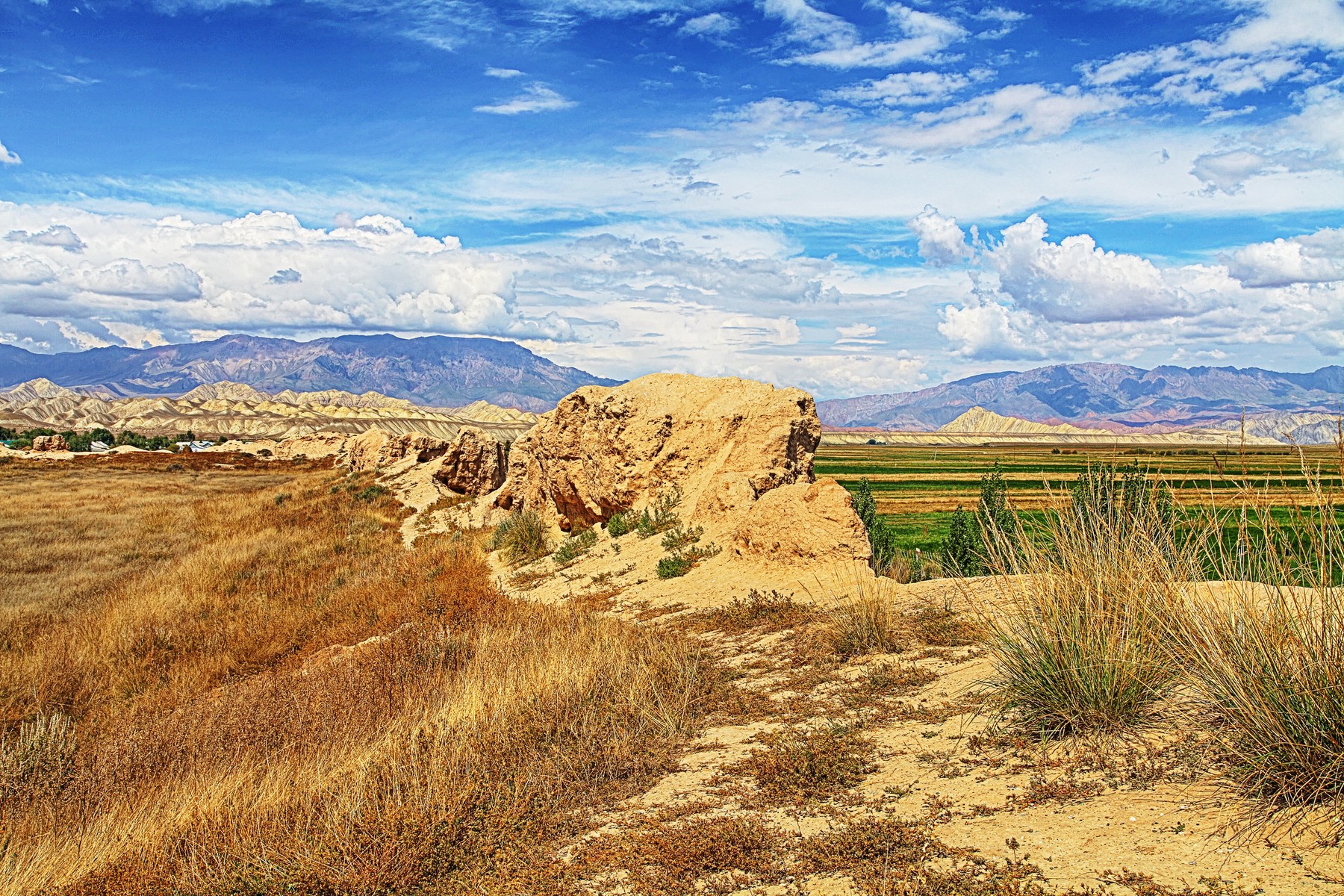
科绍伊科尔贡遗址傲然矗立在海拔 2,500 米的阿特巴希高原上。该历史遗址位于纳伦地区阿特巴希西南约 15 公里处,靠近卡拉苏村,带有古代的回响。这座堡垒具有独特的方形外观,是丝绸之路的重要地标,甚至从卫星图像中也可以看到(查看下面的地图),使其成为无人机摄影和探索的理想地点。该建筑的庞大表明这座曾经繁华的城市规模相当大。今天,游客可以自由地漫步在该地区,惊叹于堡垒城墙的高耸遗迹,其中一些城墙仍然高达惊人,并探索内部建筑的废墟。散落的陶器碎片随处可见,提醒人们中亚拥有丰富但经常未被充分探索的考古遗产。
这座堡垒的历史可追溯到公元 7 世纪,周围曾是一座繁华的城市。根据考古发现,大多数居民似乎都从事手工艺和贸易。这座堡垒的起源可能可以追溯到突厥时期,但传说它是由英雄玛纳斯建造的,据说他为朋友科绍伊修建了这座堡垒,科绍伊是《玛纳斯》史诗中著名的人物。
科绍伊科尔贡的选址绝非偶然,它被战略性地选为监视和守卫整个高原,以及控制丝绸之路这一部分的交通流量。科绍伊科尔贡坐落在附近山脉脚下的卡拉-科云河旁,这一有利位置为堡垒的守卫者提供了无与伦比的有利位置。他们可以观察周边地区的所有活动,并发现远处任何即将到来的威胁。
考古发掘发现了堡垒墙内用于居住和制造的建筑遗迹。研究人员已确认科绍伊科尔贡就是人们经常提到的中世纪城市阿特巴什,该城市主要在 9 世纪至 12 世纪繁荣发展。然而,即使在帖木儿时代,该遗址仍然很活跃。


科肖伊科尔贡博物馆
遗址旁边是当地历史博物馆,专门保存从遗址出土的文物。这些文物从家居用品、武器到服装,应有尽有,为人们了解曾经居住在该地区的人们的日常生活提供了一扇窗口。博物馆本身由一位来自卡拉苏的商人私人资助,他热衷于保护科绍伊科尔贡免遭抢劫和非法挖掘。博物馆的管理员总是热衷于分享遗址的历史,尽管他只会说俄语或吉尔吉斯语。这里有许多有趣的文物和地图,正在进行的考古工作继续带来令人着迷的发现。目前正在努力将科绍伊科尔贡列为联合国教科文组织世界遗产。
科绍伊的传说
据传说,科绍伊是史诗英雄玛纳斯最值得信赖和最忠诚的伙伴之一。科绍伊生活在公元 7-8 世纪左右,是卡塔甘部落的忠诚朋友、叔叔、首席顾问和领袖。在史诗的所有版本中,他都被描绘成一位睿智而公正的长者,能够与玛纳斯本人对抗。尽管年事已高,科绍伊身材高大、体格健壮,略显肥胖、强壮、勇敢,留着长长的灰白胡须和胡子,头发剃得光光的。他们第一次相遇时,科绍伊已经 80 岁了。
另一个版本的传说认为,科肖伊下令建造一座名为科肖伊科尔贡的军事堡垒,以保护新定居的土地和当地居民免受中国侵略者、其他敌人和流浪土匪的侵害。
堡垒的结构
与世界各地(无论是日本、亚洲还是欧洲)建造的其他堡垒一样,科绍伊科尔贡堡垒拥有许多相同的建筑原理和结构元素。这些相似之处使历史学家和修复者能够准确地重建堡垒的视觉形象,现在堡垒正在博物馆展出。堡垒呈矩形,长 245 米,宽 250 米,城墙上有多个塔楼。
城墙由大块粘土和夯土建造而成,这些材料以坚固耐用而闻名。这些城墙一度高达 10 米,厚度从 3 米到 8 米不等,具体取决于其高度。大约 50 座圆形或矩形塔楼战略性地沿着城墙的周边、角落和长而直的部分放置。这些塔楼作为观察点,让守军可以监视周围环境,保护大门,并在战斗期间提供避难所。
为防御工事增添了一道宽阔的壕沟,宽达 11-14 米,深约 29 米,壕沟内注满了来自附近水源的水。近 XNUMX 年来,这座堡垒始终坚守不倒,击退了无数敌人的进攻。
多年来,科绍伊科尔贡要塞有效地保护了其居民。然而,它最终面临动荡时期,屈服于游牧入侵者的无情袭击。经过一段相对平静的时期后,商队沿着古老的路线重新开始旅行。尽管恢复了活力,这座堡垒(也称为 At-Bashy)最终被蒙古入侵者占领和摧毁。
这座堡垒最终倒塌的细节仍是一个谜,但根据一些未经证实的报道,这座城市在整整一百年后由著名的中亚统治者、指挥官和征服者阿米尔帖木儿重建。在他的领导下,这座堡垒成为他的军队在东征中国时的一个重要转运站。
今天参观科绍伊科尔贡
科绍伊科尔贡位于卡拉苏村东南约 2 公里处。要到达城堡,请经过卡拉苏清真寺和战争纪念碑后左转,然后继续走到路的尽头。废墟位于右侧的田地中,农民仍在照料庄稼。如果您要前往 Chatyr Kul、Kel Suu 或 Tash Rabat 等目的地,科绍伊科尔贡是一个绝佳的额外停留地。
Koshoy Korgon fortress
The ruins of Koshoi Korgon stand proudly amidst the high plateau of At-Bashy, situated at an elevation of 2,500 meters. Located roughly 15 kilometers southwest of At-Bashy in the Naryn region, specifically near the village of Kara-Suu, this historical site carries the echoes of ancient times. The fortress, with its distinctive square shape, is a remarkable landmark of the Silk Road, even visible from satellite imagery (check the map below), making it an ideal location for drone photography and exploration. The vastness of the structure suggests that this once-bustling city was quite substantial in size. Today, visitors can freely wander through the area, marveling at the towering remains of the fortress walls, some of which still reach impressive heights, and exploring the ruins of the structures within. Scattered pieces of pottery are a common sight, a reminder of Central Asia’s rich yet often under-explored archaeological heritage.
Dating back to the 7th century, the fortress was once surrounded by a thriving city. Based on the archaeological findings, it appears that most inhabitants were engaged in craftsmanship and trade. The origins of the fortress may trace back to the Turkic period, though legends attribute its construction to the hero Manas, who supposedly built it as a mausoleum for his friend Koshoi, a figure famously mentioned in the epic of Manas.
Koshoi Korgon’s location was no coincidence; it was strategically chosen to monitor and guard the entire plateau, as well as to control the flow of traffic along this segment of the Silk Road. Nestled beside the Kara-Koyun River at the base of a nearby mountain range, this advantageous position offered the fortress’s defenders an unparalleled vantage point. They could observe all activities in the surrounding area and detect any approaching threats from afar.
Excavations have revealed remnants of structures used for both living and manufacturing within the fortress walls. Researchers have identified Koshoi Korgon as the frequently referenced medieval city of At-Bash, which flourished primarily from the 9th to the 12th centuries. However, the site remained active even during the era of Timur.
The Koshoi Korgon Museum
Adjacent to the ruins is a local history museum dedicated to preserving the artifacts unearthed from the site. These artifacts range from household items and weapons to clothing, offering a window into the daily lives of the people who once inhabited this area. The museum itself is privately funded by a businessman from Kara-Suu who is passionate about protecting Koshoi Korgon from looting and illegal excavations. The museum’s caretaker is always eager to share the site’s history, though he only speaks Russian or Kyrgyz. Numerous intriguing artifacts and maps can be found here, and the ongoing archaeological efforts continue to yield fascinating discoveries. Efforts to have Koshoi Korgon recognized as a UNESCO World Heritage Site are currently underway.
The Legend of Koshoi
According to legend, Koshoi was one of the most trusted and loyal companions of the epic hero Manas. As a devoted friend, uncle, chief adviser, and leader of the Katagan clan, Koshoi lived around the 7th-8th centuries. Throughout all versions of the epic, he is portrayed as a wise and just elder, capable of standing up to Manas himself. Tall and robust despite his age, Koshoi is described as slightly overweight, strong, and courageous, with a long grey beard and mustache, and a shaved head. Their paths first crossed when Koshoi was already 80 years old.
Another version of the legend suggests that Koshoi ordered the construction of a military fortress, known as Koshoi Korgon, to protect the newly settled lands and the local population from Chinese invaders, other enemies, and roaming bandits.
The Structure of Fortress
Much like other fortresses built across various parts of the world—be it Japan, Asia, or Europe—Koshoi Korgon shares many architectural principles and structural elements. These similarities have enabled historians and restorers to accurately reconstruct the visual representation of the fortress, now on display in the museum. The fortress, rectangular in shape, measured 245 by 250 meters and featured multiple towers along its walls.
The walls were constructed using large clay blocks and rammed earth, materials renowned for their strength. These walls once stood as high as 10 meters, with a thickness ranging from 3 to 8 meters, depending on their height. Approximately 50 circular or rectangular towers were strategically placed along the wall’s perimeter, at the corners, and along the long, straight sections. These towers served as observation points, allowing defenders to monitor the surroundings, protect the gates, and provide refuge during battles.
Adding to its defenses was a wide ditch, measuring up to 11-14 meters across and about three meters deep, which was filled with water from a nearby source. For nearly 29 years, the fortress stood firm, repelling countless enemy attacks.
For many years, the Koshoi Korgon fortress effectively safeguarded its inhabitants. However, it eventually faced tumultuous times, succumbing to the relentless raids of nomadic invaders. After a period of relative calm, trade caravans resumed their journey along the ancient routes. Despite this resurgence, the fortress—also known as At-Bashy—was ultimately captured and destroyed by the Mongol invaders.
The details of the fortress’s final downfall remain shrouded in mystery, but according to some unverified reports, the city was rebuilt exactly one hundred years later by Amir Temur (Tamerlane), the renowned Central Asian ruler, commander, and conqueror. Under his leadership, the fortress served as a critical transshipment point for his army during campaigns to the east against China.
Visiting Koshoi Korgon Today
Koshoi Korgon lies about 2 kilometers southeast of the village of Kara-Suu. To reach the citadel, take a left turn after passing the Kara-Suu mosque and war memorial, then continue to the end of the road. The ruins lie in a field to the right, where farmers still tend to their crops. Koshoi Korgon makes for an excellent additional stop if you’re traveling to destinations like Chatyr Kul, Kel Suu, or Tash Rabat.