• 卡隆古城Ancient City of Karon
卡隆古城是一个考古遗址,位于戈尔诺-巴达赫尚自治区的达尔沃兹区鲁兹瓦伊定居点以东1公里处,该自治区是一个被帕米尔山脉环绕的广阔省份。它坐落在佐吉克山上,东、南、西三面被喷赤河环绕。这座考古遗址占地45公顷,包含卡隆城的遗迹,年代可追溯至青铜时代至公元17世纪。自2012年以来,在该遗址进行的考古发掘工作已出土数座独特建筑,包括一座被解读为 ...
卡隆古城是一个考古遗址,位于戈尔诺-巴达赫尚自治区的达尔沃兹区鲁兹瓦伊定居点以东1公里处,该自治区是一个被帕米尔山脉环绕的广阔省份。它坐落在佐吉克山上,东、南、西三面被喷赤河环绕。这座考古遗址占地45公顷,包含卡隆城的遗迹,年代可追溯至青铜时代至公元17世纪。自2012年以来,在该遗址进行的考古发掘工作已出土数座独特建筑,包括一座被解读为 ...
DescriptionThe exact historical journeys of the Silk Roads on the territory of modern Tajikistan and Central Asian countries were never static. Cities, towns, caravansaries and trade stations were gaining and losing importance in the different periods of
【名称】哈尔库什墓地【位置】塔吉克斯坦国家直辖区吉萨尔区【年代】公元7世纪下半叶~8世纪上半叶【解题】墓地位于施尔肯特河与哈尔库什河汇合处的一个缓坡中部,位于同名的遗址北侧60米处。墓地分为两层,早期中世纪(7世纪~8世纪)和晚期中世纪(10世纪~13世纪)。晚期中世纪的墓葬可能是当时在该区域开采铁矿的人群留下的,该区域有卡拉塔格山最为丰 ...
【名称】早期图尔哈墓地【位置】塔吉克斯坦哈特隆州沙尔图兹区贝什肯特谷地【年代】公元前9世纪~前8世纪墓地位于塔吉克斯坦哈特隆州诺西里·胡斯拉夫区贝什肯特村北侧的山前冲积扇上,墓地南北长800米,东西宽400米。1953年,塔吉克斯坦考古考察队科巴店分队在贝什肯特谷地调查时发现了图尔哈墓地遗存。1955~1959年,А. М. 曼德施塔姆(А. М. Ман ...
阿克别特墓地【名称】阿克别特墓地【位置】塔吉克斯坦山地-巴达赫尚州奥克苏河右岸【年代】公元前5世纪~前3世纪【解题】墓地位于奥克苏河右岸,自克孜勒-拉巴特向北6千米处。墓地的面积受限于卡拉库里河,该河是奥克苏河的右翼支流。在沿河岸3千米宽的洪泛区的第一和第二阶地上散布着100多座墓地;大多数都位于第一阶梯(约60座)。墓地形制可分为三类: ...
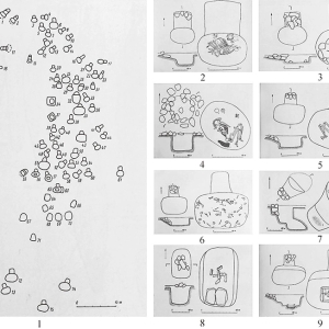
图尔喀墓地位于塔吉克斯坦贝希肯特谷地中部,是当地规模最大、数量最多的墓葬群,南北长800米、东西宽400米范围内分布着348座墓葬,按集中程度分为18组。它属于贝希肯特文化,年代推测为公元前14至前8世纪,墓葬形制以偏洞室墓为主(占比超80%),封堆大小与墓主性别、年龄相关,洞室多位于墓道东侧,遗骸以单人仰身直肢葬为主,头向多朝正北。该墓地是研 ...
【名称】土布哈那墓地【位置】塔吉克斯坦北部吉萨尔盆地【年代】公元前1世纪~公元4世纪土布哈那墓地位于塔吉克斯坦北部吉萨尔盆地吉萨尔(Hisor)古城东约1.5千米的土丘之上,位于两河交汇处,西侧为Hanaka河,南为卡菲尔尼干河。1946~1948年,迪亚科诺夫(М. М. Дьяконову)带队首次对该墓地进行发掘,共计发掘墓葬96座。1960年开始利特文斯 ...
古骨咄文化遗产遗址群Cultural Heritage Sites of Ancient Khuttal缔约国:塔吉克斯坦地区:亚太地区提名标准:标准(ii)(iii)列入标准:标准(ii)(iii)遗产类型:文化遗产(纪念物,系列遗产)咨询机构评估意见:补报 R (Referral)最终审议结果:列入I(Inscription)简要描述该系列遗产代表了公元7至16世纪存在于帕米尔山麓(Pamir Mountains)的 ...
塔吉克斯坦虎谷自然保护区的托喀依林Tugay forests of the Tigrovaya Balka Nature Reserve© A. Butorin遗产类型:自然遗产列入标准:(ix)该遗产位于塔吉克斯坦西南部、阿富汗边境的瓦赫什河和潘吉河交汇处。保护区包含广阔的河岸图盖(riparian tugay)生态系统、卡什卡-库姆(Kashka-Kum)沙漠、布里托(Buritau)峰,以及阿鲁克套(Aruktau)山脉南麓 ...
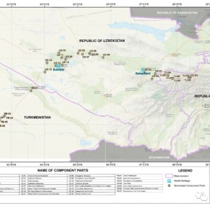
塔吉克斯坦/土库曼斯坦/乌兹别克斯坦Silk Roads: Zarafshan-Karakum Corridor丝绸之路:扎拉夫尚-卡拉库姆廊道ICOMOS建议无保留列入扎拉夫尚-卡拉库姆廊道是丝绸之路在中亚的关键路段之一,它连接着来自四面八方的其他廊道。本项目共有34个遗产点,分布在崇山峻岭、肥沃的河谷和荒无人烟的沙漠中,全长866公里,自东向西沿扎拉夫尚河延伸,再向西南沿着穿 ...
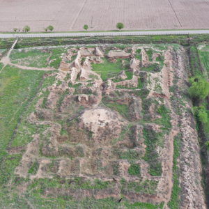
2021年6月27日,(杜尚别,夏冉)塔吉克斯坦境内的遗址很多(超过3000处),笔者比较关注的是粟特时期的一些遗址。 航拍高清视频如下: 希索纳克定居点遗址 该遗址作为丝绸之路泽拉夫善-卡拉库姆廊道(或者称之为泽拉夫善-锡尔河廊道)的一部分,于 2021 年初被提名为联合国教科文组织人类遗产暂定名录。 希 ...
窣堵利瑟那国 : 中亚古国名。《大唐西域记》窣堵利瑟那国,即《新唐书·西域传》率都沙那国,又作东曹。其政治中心在今塔吉克斯坦之乌腊提尤别。参见【苏对萨那】条注。
数满城 : 中亚古城名。唐天马都督府治所。故址在今塔吉克斯坦杜尚别市附近。
卡拉卡哈(Kalai Kahkakha)古城遗址卡拉卡哈古城遗址位于塔吉克斯坦沙赫里斯坦市西侧,地处西天山北麓山前平缓台地上,南侧为山,东临河,西、北均为陡崖,地势险要。卡拉卡哈古城是公元6-9世纪粟特东曹国的首都,汉语文献作率都沙那、苏对沙那、劫布斲那、苏都识匿等。该城址由结构复杂的城堡、具有防御性的城墙和角楼共同组成。东北部是统治者居住的宫 ...
卡拉伊米尔(КалъааиМир)古城遗址卡拉伊米尔古城遗址位于塔吉克斯坦库尔干秋别市西南70公里的乔尔伯格镇内,地处河流左岸的台地上,四周皆是现代居民区。古城遗址位于高出周围地面十余米的大土丘上,平面近方形,边长约150米。其四周分布有断续的城墙,最高处残高4米,西墙可见土坯垒砌的痕迹。城墙外围有城壕,只有一个城门,位于西墙中部。城 ...
Description Territory of the reserve referred to the Central Asian natural climatic range with highland Zorkul Lake of glacial origin. This lake situated on the altitude of 4100-4200 m. Within the te
Description The botanical zakaznik (reserve) Kusavlisay situated on the North slopes of Turkestan mountain ridge to the north direction from Shahristan pass of Dushanbe – Hodjent road. It is contiguo
Description The reserve situated in the undercurrent of Vakhsh River between Pyandj and Kafirnighan rivers at the board of Afghanistan. Its territory elongated for the 40 kms from south-west to north
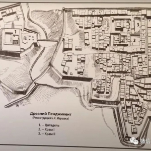
Description The site of ancient town of Pyanjekent is the center of one appannage possession of Sogd of V-VIII centuries.It consists of a vast citadel with three belts of fortifications; the city pro
Description The site of ancient settlement has oval - rhombic form, area is 10 hectares. From three sides it is cut through with river-beds, reaching the valley to the west. They are 40-50 m. deep.
Description Territory of reserve situated in the mountains at the altitude 1000-2000 m, on the slopes of Hazratishoh mountain ridge. The extension of the reserve from north to south is 18 km; from we
Description   ObjectName Country(province, region) Area (ha)Geography (width/longitude) or coordination of the center (approximately) 1 Ancient Penjikent Penjikent town 23 N39°29'13", E67°37'10"
Description The citadel is situated in the south-west part of the site of ancient town, now it's named Khisht-Tepa of the kishlak of Kurban Shaid of Vose Region. It has a territory of 600 x 200 mete
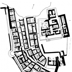
彭吉肯特古城遗址位于塔吉克斯坦彭吉肯特市东南1.5公里泽拉夫善河南岸台地上,西距撒马尔罕68公里。该城始建于公元5世纪,繁荣于七八世纪之交,722年部分毁于阿拉伯人人侵而迅速衰落,760年全部毁废。自1946年起,先后由苏联考古学家A.Ko.雅库博夫斯基和A.M.别列尼茨基主持发掘。古城由防卫性质的城堡、围以城墙的内城和作为商业、手工业区的外城以及南郊 ...
桑加沙(Sanjar Shah)古城遗址桑加沙古城遗址位于塔吉克斯坦彭吉肯特市东11公里处,地处泽拉夫善河与其支流交汇处东侧山前台地上,南倚西天山,北临河谷陡崖,东西为沟谷,地势险峻。桑加沙古城发现于1947年,并做了简单的地形测绘,当时测量师在古城东南角大门附近还可以观察到一个迷宫式建筑,现已消失。1974年,古城被当地开发商严重破坏。该城址据说 ...
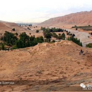
TJ-05 Tali Khamtuda fortressThe well-preserved cross-shaped fortress of the first centuries CE, the period immediately predating the blossom of Sogdian civilization on the Silk Road. The uniqueness and value of Tali Khamtuda lies in the fact that it was p
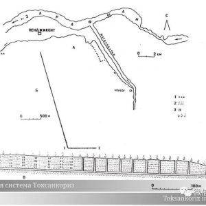
塔吉克童话和文学大师尼扎米的作品《胡斯拉夫与希琳》中都反映了打破岩石出水的传说。它们基于现存的古代真实物体——古代伊朗的坎儿井——人工制造了数公里的地下水管。而我们,在中亚,早已拥有自己的灌溉系统。 托克桑坎儿井灌溉系统。 托克桑坎儿井是一个保存完好的渡槽系统,位于片治肯特附近的泽拉夫善河流域。当地的繁荣很大程度上依赖于对农作物 ...
库姆要塞,位于穆格山堡垒以南 6 公里处的古老山区粟特聚落库姆,至今仍保留着它古老的名字。库姆要塞,2014年9月航拍。 它位于一座小山上,位于库姆现代定居点的北郊。根据历史学家雅库博夫的说法,库姆是帕尔加尔的主要军事据点——这是古代泽拉夫善上游这个山区的名字(参考《7-8 世纪的帕尔加尔》。雅库博夫著)。 根据对幸存建筑墙体和建筑学家 ...
(公元7世纪-8世纪早期) 它位于艾尼地区现代麦德姆村庄东北 1 公里处的一座小山上(该名称从粟特时代就被保留了下来),库姆村以西 5 公里处。在这个山区,通常有适合耕种的土地,因此,在泽拉夫善河的支流上普遍存在有定居点。 历史学家从中获得了关于普通粟特人生活的丰富考古资料:他们估计了居民人数和房屋大小、种植和储存的农作物数量、定居和 ...
穆格山城堡遗址 : 8世纪初中亚粟特城堡遗址。位于泽拉夫善河上游该河与库马河合流处的穆格山上(塔吉克斯坦札赫马塔巴德区内)。“穆格”在塔吉克语中意为“王”。该堡当是片治肯特粟特王公季华什契奇的一座要塞,722年被阿拉伯军攻毁。1933年苏联考古学家A·A·弗列依曼主持发掘。城堡建在穆格山顶西南角上,四面有石基土坯堡墙环绕。在石铺台基上,东西并列五 ...
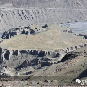
Khisorak settlement N 39° 26' 29,365", E 69° 41' 8,006"TJ-01 Khisorak settlementIt is the most highland urban monument (above 7 ha) in Central Asia, 2250 m above sea level, with outstanding preservation of the architecture of the 7th– 8thcenturi
DescriptionThe Silk Roads extended over 6500 km and connected East, South, and Western Asia with the Mediterranean and European world and served as historical network of interlinking trade routes, intercultural dialogue, exchange of traditions, sciences,
Murghob,formerlyPamirskiPostisthecapitalofMurghobDistrictinthePamirMountainsofGorno-BadakhshanAutonomousRegion,Tajikistan.Withapopulationof4,000,MurghabisabouttheonlysignificanttownintheeasternhalfofGorno-Badakhshan.ItisthehighesttowninTajikistanat3,650ma
杜尚别名称在波斯语解作“星期一”,这亦指杜尚别著名的星期一市场。 1929-1960年曾名“斯大林纳巴德”。1961年改今名。塔吉克斯坦经济、文化中心。在塔吉克斯坦西部吉萨尔盆地中。原为小山村,1925年建市。交通枢纽。有窄轨铁路通铁尔梅兹等地,并有公路干线北通苦盏,东至霍罗格。航空要站。工业以棉纺织、缫丝、食品加工和机械制造(纺织机、农机、电缆 ...