遗产数据库
Kanka康卡(窳匿城)
摘要: Chinese_Name康卡English_NameKankaTimes公元6-7世纪至公元11-12世纪窳匿城 : 汉西域城名。见于《汉书·西域传》。为康居五小王之一窳匿王都城。“去都护五千二百六十六里,去阳关七千五百二十五里”。约在今乌兹别克斯坦塔什干市中心的坎卡 (Kanka)遗址。位于贾萨尔特斯河畔的安条克,有一个古老的聚落坎卡坐落于现代塔什干市郊的古老聚落坎卡,宛如一位静 ...
Chinese_Name
康卡
English_Name
Kanka
Times
公元6-7世纪至公元11-12世纪
窳匿城 : 汉西域城名。见于《汉书·西域传》。为康居五小王之一窳匿王都城。“去都护五千二百六十六里,去阳关七千五百二十五里”。约在今乌兹别克斯坦塔什干市中心的坎卡 (Kanka)遗址。
位于贾萨尔特斯河畔的安条克,有一个古老的聚落坎卡
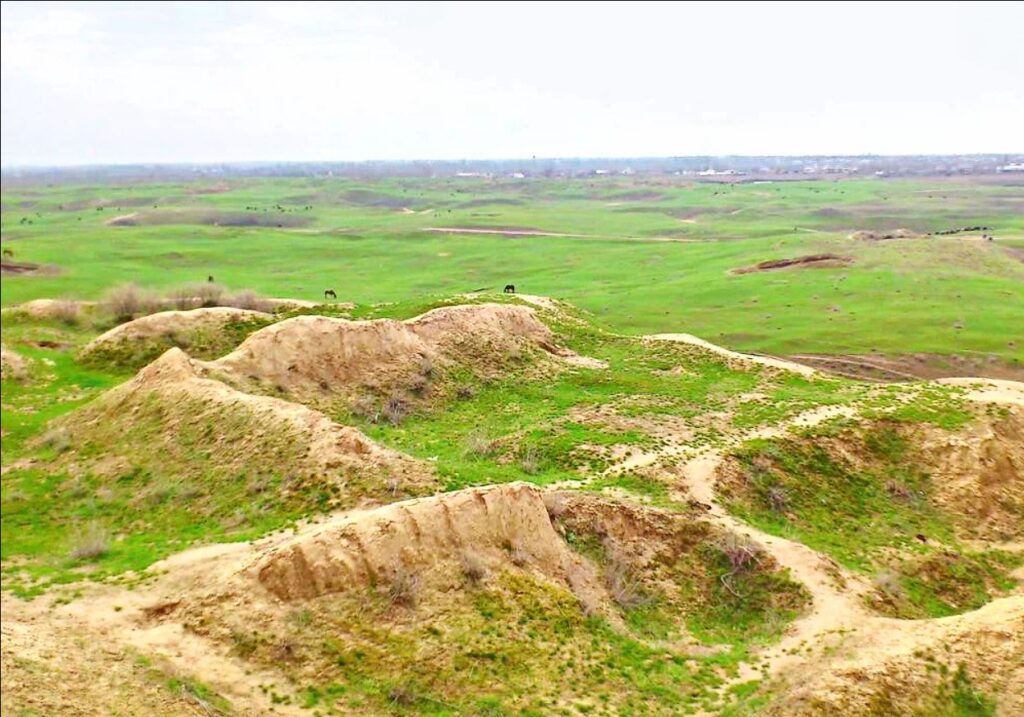
坐落于现代塔什干市郊的古老聚落坎卡,宛如一位静默的见证者,诉说着文明的兴衰变迁。这座位于繁华都市西南约80公里处的古老遗址,是乌兹别克斯坦最重要的考古宝藏之一,让人们得以一窥该地区传奇般的过往。
坎卡的起源可追溯至公元前2世纪或3世纪,是肥沃的奇尔奇克河谷和广阔的塔什干绿洲中城市文化的关键摇篮。它被认为是粟特文明最早的都市中心之一,粟特文明是一个以复杂社会而闻名的古代伊朗文明。坎卡昔日的辉煌遗迹见证了伊斯兰时代到来之前,中亚地区早已蓬勃发展的先进城市化进程。
坎卡(Kanka)的土壤孕育了丰富的发现,为人们描绘出一幅其复杂城市结构的生动画卷。该遗址的东部区域揭示了最古老的地层,那里出现了令人惊叹的防御工事。在这里,由厚重泥砖砌成的巨大墙壁彰显出该聚落强大的防御能力。
坎卡(Kanka)的中心是城堡,这是一座设防的皇家住所,暗示着一个由强大精英阶层统治的分层城市社会。出土的文物——从硬币、陶器到陶俑和雕刻精美的骨制品——为我们提供了了解那个时代文化、经济和艺术命脉的窗口。
在坎卡附近发掘的周边墓葬群生动地展现了当地居民的葬礼习俗和信仰,进一步丰富了我们对这个古老社区的了解。
坎卡(Kanka)的历史画卷跨越多个时代,从阿契美尼德王朝到希腊-巴克特里亚王朝,随后是贵霜王朝和赫帕提利王朝时期,最终在8世纪的阿拉伯征服中达到高潮。每一层都为更细致地理解该地区错综复杂的历史做出了贡献,包括琐罗亚斯德教、佛教以及最终的伊斯兰教的传播。
坎卡(Kanka)精心规划的城市风貌表明,它曾是一个繁华的经济中心,可能与连接东西方的传奇丝绸之路有关。其布局的精致程度反映出这座城市不仅组织有序,而且繁荣兴旺,影响力远播四方。
与许多古代遗址一样,坎卡面临着自然衰败和人为侵占的威胁。乌兹别克斯坦政府和国际机构正在合作开展保护行动,以保护剩余的建筑和文物。坎卡是联合国教科文组织世界遗产名录的有力候选者,这将为其提供更强的保护和全球认可。
坎卡的考古价值远不止于当地历史。它作为一条至关重要的渠道,连接着塑造中亚的历史潮流,为解读塔什干地区错综复杂的叙事以及数千年来这一地区所经历的更广泛的文化变革提供了关键见解。对于勇敢的旅行者和历史爱好者而言,坎卡为他们提供了与古代世界的深厚联系,其遗迹至今仍回荡在当下。
Description
A site of ancient settlement of Kanka in the territorial and administrative attitude is located in 80 km in the southeast from Tashkent, in the southeastern outskirts of Eltamgali settlement. It is the ancient and one of the large city centers of Tashkent oasis. In its northeast part rise the most powerful construction of the city-citadel-arch, with the height more than 40 meters with palace of governor, man-sided bastions and house temple. The total area is 220 hectares. Kanka divides into three parts - citadel, shakhristan - town territory and rabad - trade and commercial outskirt. Citadel is almost square-shaped at the height of 35 m. There is a huge castle with four towers at the base of citadel. The castle has been separated from building with huge ditch. It stands on the powerful platform, the top part of which has nine lines of pahsa (adobe clay). Inside of the platform are concealed more ancient buildings. There are buildings of VI - VII and XI - XII centuries in top layer of citadel. In the centre of northern facade was placed the only entrance to citadel. Distinctive peculiarity of Kanka is that it has three Shakhristans, establishing of which reflects stages of dynamics of town development. Shakhristan I includes citadel (in the northwestern edge and it has correct square form of quadrangle stretched to the west from the river. The height of fortification walls from its base is 26 m. Shakhristan I was encompassed with wide ditch (about 35 m.). The only gate is in the center of the southern side. Evidently, there was built a tower, from where was thrown a drawbridge. The depth of the cultural layers is not the same, and in the western part, it equals to 26 m. In the territory of Shakhristan I was found urban development of XI - XII centuries and ruins of town temples of VI - VII centuries. Shakhristan II surrounds Shakhristan I from three sides and it has square form too, but it stretches along riverbed. Its total area equals to 45 hectares. It has very compact planning and encompassed with its own fortification wall. Separation of this territory is the result of temporary shortening of urban territory in the beginning of VII century. Shakhristan III includes all these parts; its planning nears to trapezium. Total area of urban territory, surrounded by the stronghold walls, is occupied 160 hectares. It has discovered that there was a terrace and little ditch in front of stronghold walls. Southwestern and Central tracts of Shakhristan III have been planned very densely with street net and bazaar squares. Western and northeastern parts do not have any buildings. During the archeological researches on the Kanka site of ancient settlement was discovered a palace of the ruler with house temple of fire in citadel. The monumental city temple was discovered in Shakhristan I, direct data that is given in Chinese sources. The unique discovered here the remains of monumental lists of temple and type-bull connected with Manichean religion. The residential area, industrial workshops, big monumental caravanserai and bazaar squares were discovered in Shakhristan III.
Type1
Central Towns
Type2
Outcomes
Type3
Tentative Heritage
States
Uzbekistan
Province
Tashkent Region
Municipality
Akkurgan District
Property_Area
220 ha
Buffer_zone_area
Elements
OUV
A site of ancient city is unique as monument of history and culture humanity, town-planning history of Uzbekistan and included into the list of ten great sites of ancient cities of Central Asia. Monument is unique by its safety
Criterion
Integrity
Authenticity
Protection and management
History
Corridor
Notes
By its size, meaning and role became close to such cities like Merv, Samarkand and Balkh. Kanka is the first capital of Chach state, small estate of Kanguy. Monumental fortification walls with towers surround the huge territory of more than 160 hectares. There are three cities inside, allocated into each other, and each of them by own fortification, curtains and ditches. Inside-small town typical of antique plan, once it has affixed with other suspension bridge.
There are unique production shops and city caravanserai, which were discovered as well in this part of the settlement. Rabad encompasses urban territory as horseshoe from the east and southwest. It is unknown whether stronghold walls have been installed because large territory of rabad is ploughed up. City appeared in the IV century B.C. and it was identified by the Greek sources with Antihiey Zayaksartskoy. In further centuries it was apart of Kanguy State and was known as a first capital of Chach (in Chinese sources - Yuni-Shi). The north route of the Great Silk Road ran through it. It was described as Kharashet in Arabian sources (etymological meaning is «the city of holly farna»), a second under the economical and cultural center of Shash in Middle Age.
ONE OF THE EARLIEST CITIES OF SOGDIANA
An ancient settlement Kanka, Antioch on the Jaxartes