|
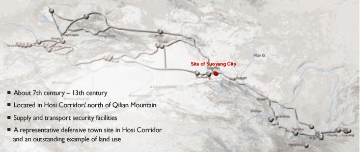
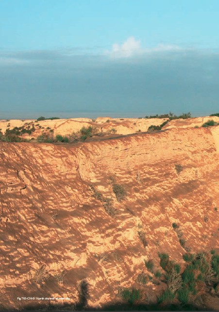
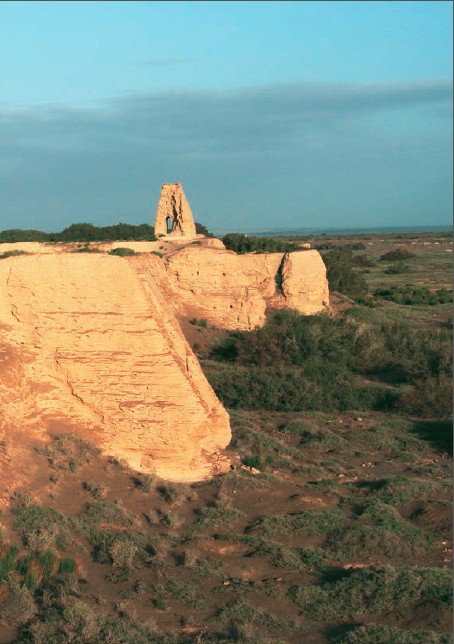
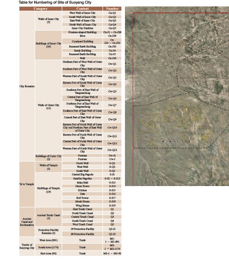
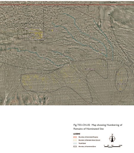
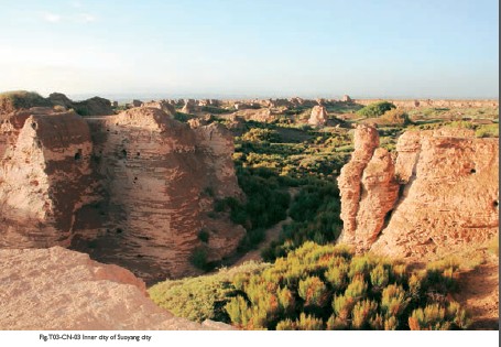
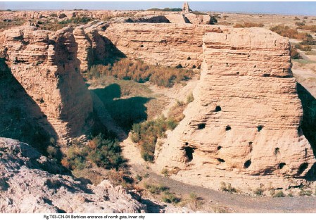
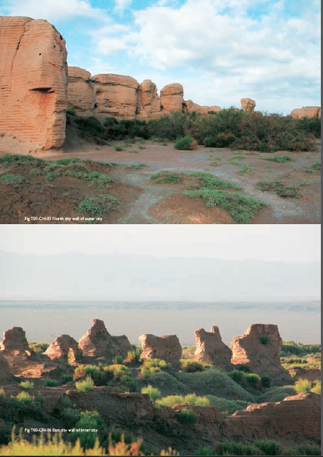
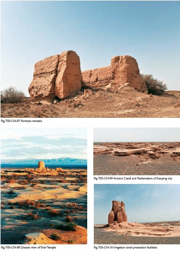
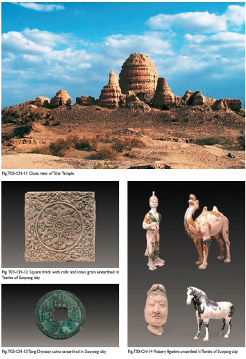
(1) Contribution to the Silk Roads' OUV The site of Suoyang City was the transportation hub on the ancient Silk Roads, linking the Central China with the Western Regions. As an outstanding example of land use in Hosi Corridor, it is a representative defensive town safeguarding long-distance transportation and communication, demonstrating mankind’s dependence, utilization and transformation of natural environments of Gobi deserts, and closely involved in trade and commercial activities along the Silk Roads. (2) General Information The site of Suoyang city is located 62km southeast of Guazhou county, Jiuquan city, Gansu province, in the Gobi desert. The ruins are adjacent to Changshanzi Hill on its south, an extension of the Qilian Mountains. Shule River and Yulin River flow past the east and west sides of the site respectively. The property area of Suoyang city covers 15,788.6 hectares. Historical remains include City Remains, Ancient Canal and Reclamation, Tombs and Ta'er Temple. Initial archaeological surveys and excavations indicate that the site of Suoyang City dates back to the 7th to the 13th century86, presumably the site of ancient Guazhou Prefecture during the Tang Dynasty. The City Remains contains the inner city, outer city, and two fortress sites at the northwest corner of the outer city. The inner city and outer city are of irregular square shapes. The inner city covers an area of about 285,000 square meters, and a partition wall divides it into the east and west parts. Remains of facilities like city gate, barbican, Mamian (horse-faced bulge wall for defense) and turret have been discovered. An east-west partition wall in the northwest of the outer city divides the outer city into two parts, the north and south parts. Yangmacheng, a wall of 20 to 30 meters has been found outside the inner city wall on the east and north sides respectively, which was built as defense fortifications. The two fortresses, located at the northwest corner of the outer city, are square-shaped structures of rammed earth, with a distance of 80 meters between them. The Remains of Ancient Canal and Reclamation are distributed around the city, including the dredging system, dams, trunk canal, branch canal, lateral canal and sublateral canal. The total length of trunk canal and branch canal is about 90km, which irrigated about 60 square kilometers of arable land. The Tombs of Suoyang City are located on the south and southeast of the Suoyang city. A total of 2106 tombs have been discovered in an area of 5km north-south wide and 16km east-west long. They are mainly Tang Dynasty tombs. Tri-color potteries of horses, camels and human figurines, beast statues guarding tombs, silk fabrics, porcelain and coins have been discovered in the tombs. In addition, the site of Ta'er Temple has been discovered 1km east of the City. It is a large Buddhist temple covering an area of 15,000 square meters. Archaeological excavations indicate that it may be a historic remain dating back to the period between the Tang Dynasty and the Western Xia Dynasty(1038-1227)87. Remnants of a conicalshaped pagoda stand in the center of the site, which is made from adobe and covered by white lime, featuring an overturn-bowl structure. Remnants of eleven smaller pagodas remain in the northern side of the big pagoda. (3) Attributes In ancient times, water conservancy facilities of Suoyang City diverted the water of Shule River to surrounding areas, irrigating lands totaling 60 square kilometers and forming an agricultural irrigation system and an oasis developed through immigration and land cultivation. These conservancy facilities reflect interaction between man and nature and guarantee long-distance arduous journeys along the Hosi Corridor which stretches up to 1000 kilometers. As an outstanding example of land use in arid areas, the site’s land development pattern, along with its surrounding heritages, also corroborate the construction history of a system of central towns and forts along the Hosi Corridor built based on Shiyang River, Hei River and Shule Rivers in the Qilian Mountains since Han Dynasty. The double walls of the inner and outer cities and the barbican, mamian, turret and forts built on walls, compose a well-preserved city defense system. Along with the ancient land cultivation area developed with irrigation technology, the town provided important safety and logistic guarantees for transportation and cultural exchanges along the Silk Roads. As a representative defensive town, this historic site bears witness to the defense system in the overall transportation guarantee system of the Empire in Central China. Cultural relics unearthed from tombs in the site of Suoyang City include silk fabrics, potteries of camels and barbarian figurines, Kaiyuantongbao coins of Tang Dynasty and more. These unearthed objects demonstrate the city’s close link with prosperous commercial and trade activities along the Silk Roads during the Tang Dynasty. The site of Ta'er Temple, featuring characteristic layouts and conical-shaped pagoda structures, reflect the spread of Buddhism in Hosi Corridor during the period between the Tang Dynasty and the Westem Xia Dynasty.
|
 |Archiver|小黑屋|丝路遗产丝绸之路:长安天山廊道的路网
( 陕ICP备07011065号-3 )
|Archiver|小黑屋|丝路遗产丝绸之路:长安天山廊道的路网
( 陕ICP备07011065号-3 )
GMT+8, 2024-4-27 00:57 , Processed in 0.189731 second(s), 20 queries .
Powered by Discuz! X3.5
© 2001-2024 Discuz! Team.