|
(1)
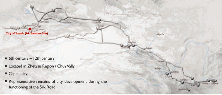
Contribution to the Silk Roads' OUV The emergence of the city of Suyab (6th-7th century A.D.) in the Chuy Valley was closely related to significant political and social changes of the period in Central Asia. The most significant of these are: 1) development of the First Turkic Kaganate (553-588 A.D.), a Eurasian nomadic empire which joined to the largest states of the time - Byzantium, Sassanid Iran, and China – to take control over the trading route connecting the Far East with the Mediterranean, 2) considerable consequent expansion of transcontinental trade along the Northern Silk Route, 3) and the migration of Turkic tribes, the Sogdian, Tocharian, and other merchants. These changes fostered development of towns in the Chuy Valley. In 7th-10th centery A.D., Suyab (also known as Ordukent or Ordu) played an important role in the political history of Central Asia, as it was a capital of the Western Turkic, Turgesh and Karluk kaganates. From 648 - 719 Suyab became one of four garrisons, i.e. one of the principal Tang’s frontier fortresses. It is first mentioned in 629 in the “Description of Western Lands” by Xuanzang. “Tang shu”(the History of Tang Dynasty) and “Xing Tang shu” (the New History of Tang Dynasty) contain detailed descriptions of trade routes, connecting Suyab and other trading centers of the Chuy valley with China. Suyab is mentioned by medieval geographers and travelers until the 10th century. City displays common construction and architectural techniques with western Central Asia and East Turkestan. (2)
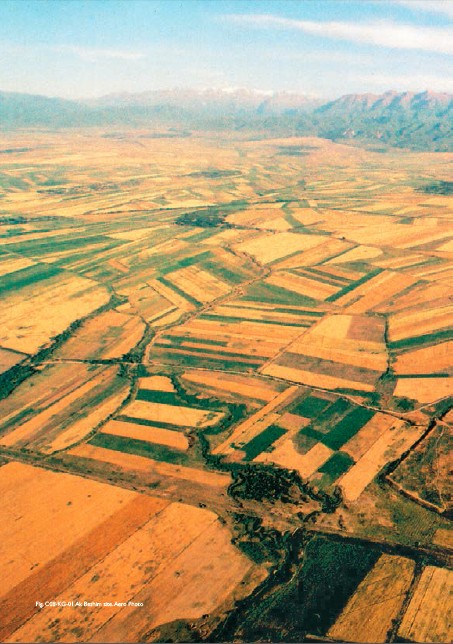
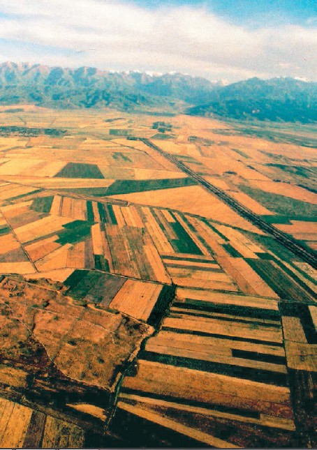
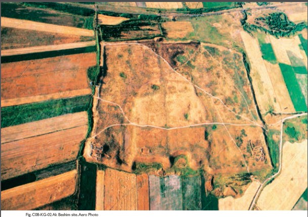
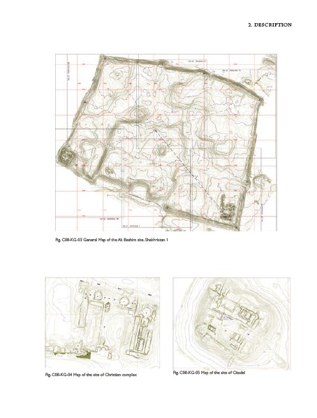
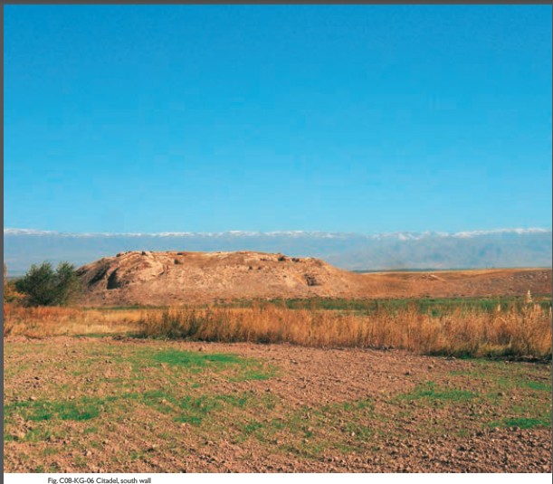
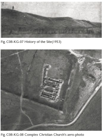
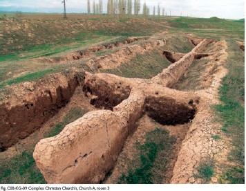
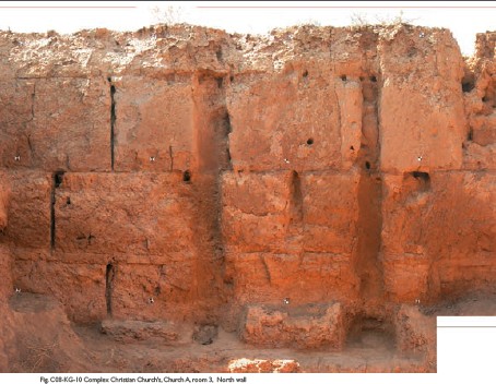
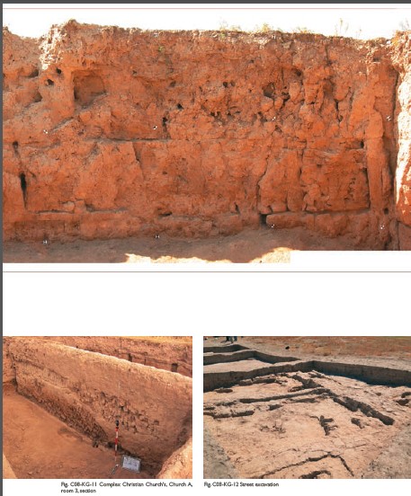
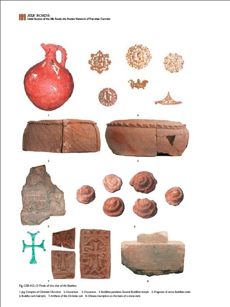
General Information The Ak-Beshim site is one of the largest and most important monuments of medieval archaeology in Central Asia. According to Chinese and Arab-Persian sources it is identified as well-known Suyab city. Remnants are located south of the Chu River and 6 km southwest of present day city of Tokmok, 50 km east of Bishkek, the capital of the Kyrgyz Republic. Layout of the city displays three areas. The First Shakhristan is surrounded by massive walls and measured 35 ha. Towers are well traced on the walls, and the Citadel is in the southwest corner. The Second Shakhristan has less massive walls covers 60ha, and adjoins Shakhristan-1 from the east. City suburbs (Rabad) surrounded Shakhristans within a radius of 1,5 kilometers and were protected by a long wall. A side branch of the Chu River borders the north of the city. City walls and buildings were earthen constructions. Most of the Shakhristan-2 and Rabad are now occupied by farmers’ fields. Excavations revealed 4 stages of development with the earliest in 6-7th centuries and the latest in 10-12th century. Sogdian merchants set up a trade post on land under Turkic rule, and in time the growing settlement became a city. The Medieval Persian geographic “Hudud-al-Alam” texts mention a city with a population of 20,000 people. In the 10th century most of Suyab’s population moved closer to the mountains, and upstream of the Burana River, in about 6 km to the southeast, a new settlement was formed (now Burana site). These two cities coexisted for two centuries close to each other, so that their long walls almost adjoin. A group of five smaller settlements are located to the north of Ak Beshim on a line along the edge of the old terraces of the Chu River 1 - 2 km apart from each other. One of them is the Small Ak-Beshim site, located 300 m from the long walls, its dimensions: 127 х 125 m. It is interpreted to be a watch castle of 10th -12th century A.D. By the 10th century Suyab had become the center of a district with several dependent settlements of considerable size (up to 4 hectares). The southern edge of the area is bordered by the Kyrgyz ridge where small rivers flow down to the valley. The small 200х330 m fortification site at the entrance to the Shamsi gorge was probably built for protecting rivers, irrigation sources, or cattle. (3) Attributes The Citadel (the fortress of the governor) in the southwest corner of the Shakhristan was excavated in 1996-1998. At its base it measures 60 × 60 m and 30 × 30 m at the top of the platform, with a rise of 8m from the base. Shakhristan - 1, the main part of the city, was fortified with perimeter walls for about 4-3,5 km. Its dimensions, starting from the northern wall and proceeding clockwise: 600 × 500 × 700 × 400 m. The walls, except for the eastern wall, are not straight lines, and have bends and ledges, which may testify to the construction of fortifications at different times, possibly that the walls of separate constructions were united in one system. The surface of Shakhristan-1 is considerably raised above the surrounding landscape, with cultural layers reaching a depth of 7.5 m. It is not identical in different parts of the site. The deepest occupation layers are in the centre of Shakhristan. An aerial view allows for tracing of gates, streets, and main constructions. The surrounding landscape with archaeological underground remains and preserved parts of the second ring city wall includes Shakhristan – 2 and Rabad - outskirts of the city. Shakhristan – 2 was an extended part of the city, also interpreted as the “Khitan quarter” or Rabad, once surrounded by walls with traces of towers. Its dimensions, starting from the northern wall and proceeding clockwise: 900 × 850 × 500 × 850 × 870 m, that makes more than 60 hectares. The occupation layer here is much thinner, than in Shakhristan-1. Inhabitants of this part of the city combined crafts with agricultural activities. Now the surface is disturbed by long-term field works and medieval ruins, including external walls, are traced poorly. Archaeological underground remains are still preserved. The perimeter of the external ring wall around Rabad was about 16 km. Separate constructions of farmstead type were traced within Rabad. In 1950s, distribution of hills (8 × 10 m to 40 × 50 m), in 15 - 50 m from each other, to the north and west from the walls of Shakhristan-1 to the long walls allowed this interpretation. This part of the city included gardens and fields. Xuanzang, Medieval Buddhist monk, noted that soil fertility was especially favorable for cultivation of millet and grapes. Buddhist and Christian constructions discovered by archeologists in Suyab confirm that natives of distant countries lived there permanently. Two Buddhist temples were excavated - Buddhist Temple 1 (B1), situated at 200m south-southwest of the Citadel, and the second Buddhist temple 400m east of B1 and a castle. The Christian church with necropolis from the 8th century AD was excavated to the east of Shakhristan as well. It was interpreted as one of the most ancient Christian constructions in Central Asia. Archeological and architectural analysis shows that there was a considerable Asian style influence (X-shaped plan, domed roof) in its architecture, i.e. open yard instead of a nave, pakhsa used as building material, etc. In the South- Eastern corner of Shakhristan, a monumental complex of Christian churches from the 10th-11th century (60 × 46 m) made of mud bricks and pakhsa was excavated in 1996-1998. This complex is located in 10-15 meters far from the outer wall and consists of three or four churches with cross – shaped bema and a large hall or courtyard in front of them. There are some utility and living rooms in the North and West. The complex was constructed in three stages. Fragments of remaining ornaments indicate that most of the rooms were decorated by painting. Finds include some clay prints with the image of Nestorian crosses and one jade cross. Other finds: Sogdian donative inscription on a jar rim and Syrian-Turkic inscription on the back of a clay plaquette with a cross. Some fragments of Uigur or Sogdian inscriptions were found on plaster with the paintings. Buddhist steles with Chinese inscriptions containing historical text, which were established in Suyab in commemoration of victorious operations of Chinese garrison against Tibetan and Turks in 677 and 679, were also discovered.
|
 |Archiver|小黑屋|丝路遗产丝绸之路:长安天山廊道的路网
( 陕ICP备07011065号-3 )
|Archiver|小黑屋|丝路遗产丝绸之路:长安天山廊道的路网
( 陕ICP备07011065号-3 )
GMT+8, 2025-7-19 07:05 , Processed in 0.427237 second(s), 20 queries .
Powered by Discuz! X3.5
© 2001-2024 Discuz! Team.