|
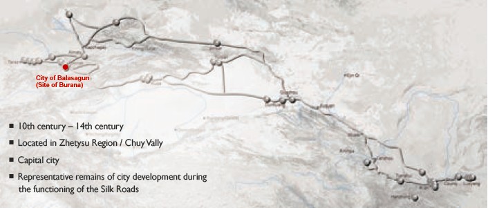
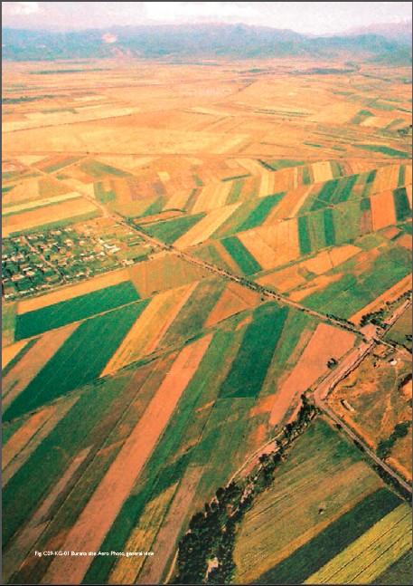
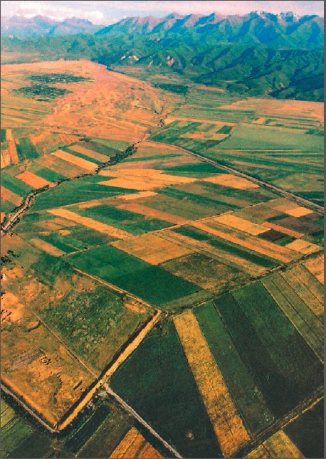
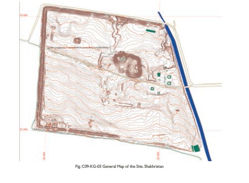
(1) Contribution to the Silk Roads' OUV Balasagun (Kuz Ordu), established in the 10th century on the site of an older settlement by Karakhanids, was one of the largest medieval cities in Chuy valley. Along with Kashgar, Balasagun was one of the capitals of the Eastern Kaganate after the Karakhanid state split up. It is an example of a new development of cities in the region during the High Middle Ages 11th –12th century A.D., influenced by political, economic and social changes. Its history witnessed new phenomena of culture, as wide application of various systems of writing, development of ancient Turkic literatures, and introduction of Islamic arts. New political culture of governance, ethics and morals rules of Karakhanid Kaganate, the first Muslim Turkic state, reflected in literary and philosophical works of Turkic scientists - Mahmud Kashgari, Yusuf Balasaguni. It was saved from destruction by Genghis Khan's Mongols, and was renamed Gobalik (“good city”) in the 13th century, but the city lost its importance and had disappeared by the 15th century. The town had a complicated layout covering 25-30 square kilometers. Archaeologists discovered ruins of a central fortress or palace complex dated from 12th – beginning of 13th century A.D., religious buildings, dwellings, a bathhouse (11th – 12th century A.D.), water supply system (ceramic pipes delivering water, Christian and Muslim cemeteries with examples of inscriptions in different languages. Two circles of walls surrounded the town with its arable land, workshops and markets. Although the Karakhanids, practiced Islam, they were tolerant of other religions. (2) General Information The Burana site - remains of Balasagun is situated 2.5km east of Donarik village and 6 km to the southeast of the city of Suyab (site of Ak Beshim). In the 10th century the population of Suyab moved closer to the mountains, upstream of the Burana River a new settlement was formed in the vicinity of Shamsi gorge. It is known that in 960, Satuq Bughrâ-khân and his son Mûsâ converted the whole population of Balasagun to Islam. This historical fact sustains the construction of a mosque in the same period as a built expression of the new religion. Burana ruins provide materials for 10th-14th century and belong to the last period of existence of settlements in the Chuy valley. (3)
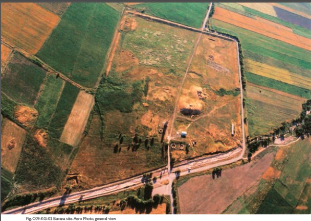
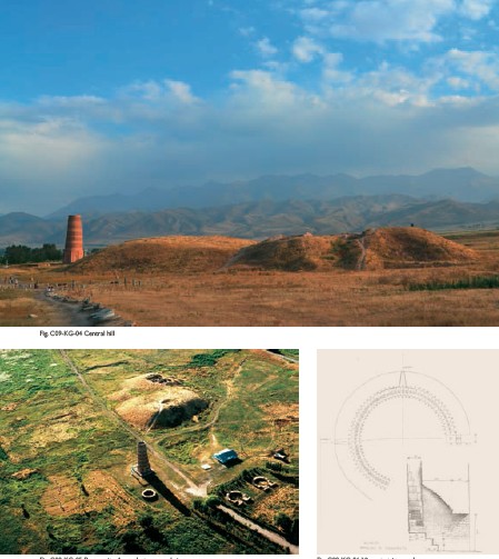
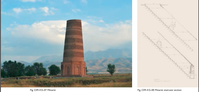
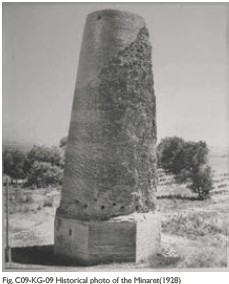
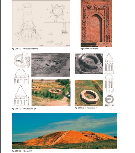
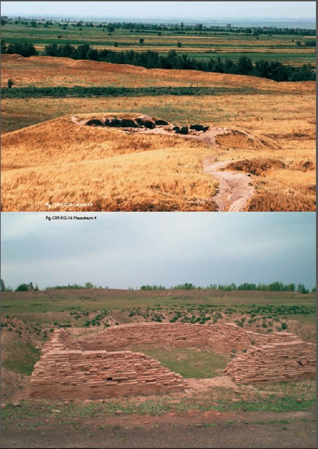
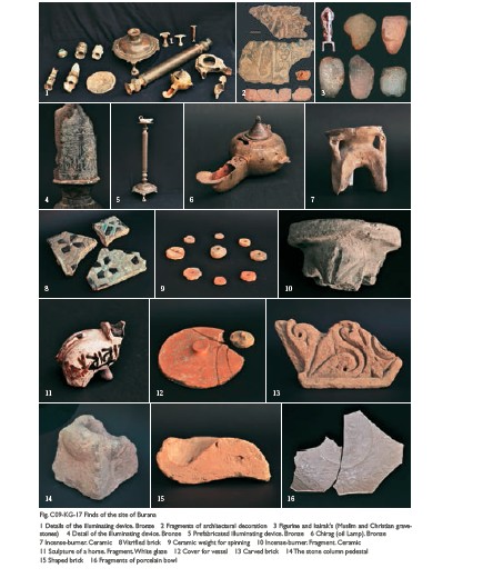
Attributes The dominant feature at Burana site is the Minaret (MI), built at the end of 10th century, still surviving with a height of 24 m, initially it was 44,7 m. Presumably, top gallery of the tower was destroyed during one of the strong earthquakes in 15th or 16th century. Depth of the base is about 3,6 m. Probably, the most ancient of preserved Minarets of common style (conical or cylindrical towers of equal cross-section) in the whole Islamic world, the Burana minaret became a prototype of the basic type of minarets of Central Asia, e.g. the Uzgen Minaret, Kalian Minaret in Bukhara (1127), and the Vabkent minaret (12th century); as well as a model of building technique using advanced engineering methods and architectural decorations of the time. Old pictures of the Burana tower of 1927 show the minaret from southeast. The lower part below the entrance is severely eroded. Only fragments of a single corner at a higher level at the eastern side are left. The upper part is relatively well-preserved as the decorative brick-belts are recognizable. In 1928 the minaret was consolidated by construction of a solid octagon around the base. The octagon shows no decorations and is much lower than the present-day octagon. The decorative brickwork of the cone has largely disappeared on the northwest elevation. The tower is leaning westwards. The next restoration works took place in 1970s and 1980s, when the base and octagon of the minaret were restored. Close observation, will distinguish old and new bricks on the cylindrical part of the tower. The geometry of the 6 decorative brickwork belts is different. For each belt a basic pattern is designed which is then repeatedly rotated, transposed or mirrored to fill the whole surface. The basic patterns of belts 4, 5, and 6 at the top are rather simple, but those of the 3 lowest belts show an intricate and sophisticated expression. The inner staircase is fully authentic. It is assumed that the tower was part of a mosque although no evidence has been found for this so far. Excavations determined the construction of the minaret to be completed in the second half of the 10th century. A new facing was added in the 11th century. This structure is located in an area defined by an earthen wall enclosing most of the central part of the ancient city, which measures some 450 m by 650 m. Within the walled area are four excavated mausoleums and the remains of the central palace in the form of an artificial mound 12–15 m high. A medieval baths (BH) complex was excavated in 1979. The walls enclosing the city are clearly visible. Looking for remains of the supposed mosque in the early seventies, the foundations or lower bases were found for 3 mausoleums (M1, M2, M3) close to the minaret. The first had an octagonal foundation and four graves below floorlevel. The corpses were buried in cases of burnt bricks. Another 28 persons were buried there in a later period. Pieces of wall cladding, stucco, burnt and sculptured bricks were found in the debris. The second and third mausoleums are of a different type. They are situated side by side, NE of the minaret and faced towards the river. The southern mausoleum (M2) is the best preserved with walls reaching 1m above ground. Mausoleum 4 is situated 400m-northwest of Burana minaret. It was excavated between 1984 and 1986. Several reconstruction phases were identified. By comparative study of find fragments with analogue decorations of other Central Asian buildings, M4 is dated to the 11th century. Records of Syriac-Turkic epigraphy of Zhetysu are wellknown. Grave stones of the 13th - 14th centuries, the socalled kairaks - large pebbles, which had on one or two sides the cut inscriptions in classical Syrian characters, were discovered at the Christian cemeteries of Balasagun. Inscriptions usually have dates according to Turkic calendar. The names of deceased and their parents are either Biblical-Christian or Turkic. So far, up to 30 epigraphic records with Arabic characters are known from Kairaks with Muslim epitaphs. Epitaphs are devoted to representatives of clerical order – faqihslawyers, muftis, imams, preachers. They especially emphasized the continuity in inheritance of clerical positions and titles. Merits of deceased, their righteousness and services to Islam are mentioned also; the facts of pilgrimage of the deceased to the holy towns of Mecca and Medina are specially noted. Thus, tombstone kairaks as local sources bear the valuable information on confessional, political, legal culture; they give authentic data on degree of literacy, real language situation in towns, historical and cultural interrelations and lifestyle of the medieval society. They allow perception of process of transformation and adaptation of languages and customs. Such as the inscription on kairak from Balasagun dated from the beginning of the 13th century - it is in Turkic language, but in Arabic characters: "It is a tomb of 'Umar, the son of the baker 'Aliy. Died according to Tärih in six hundred and three, according to Turkic - in a year of the monkey. Let [him] be commemorated in a prayer! " Besides its uniqueness, the epitaph is valuable also as exactly dated and localized source by history of language (probably, Karluk group which in the Middle Ages included the tribes Yagma, Tuhsi, etc., registered in this territory by Mahmud al-Kashgari in the 11th century); it is of special interest that the inscription has the term etmekçi / epmekçi - "baker", indicative from the point of view of lexicology, history of economy and household, etc. It is also important that the text mentions two dates - by Muslim era and by twelve-year animal cycle: year 603 (not by lunar but by solar calendar) "year of monkey".
|
 |Archiver|小黑屋|丝路遗产丝绸之路:长安天山廊道的路网
( 陕ICP备07011065号-3 )
|Archiver|小黑屋|丝路遗产丝绸之路:长安天山廊道的路网
( 陕ICP备07011065号-3 )
GMT+8, 2024-7-27 11:34 , Processed in 0.325211 second(s), 20 queries .
Powered by Discuz! X3.5
© 2001-2024 Discuz! Team.