|
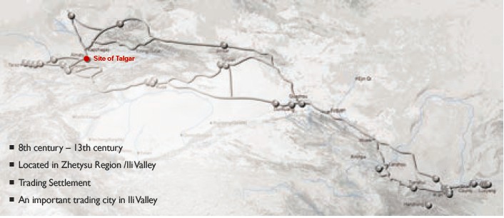
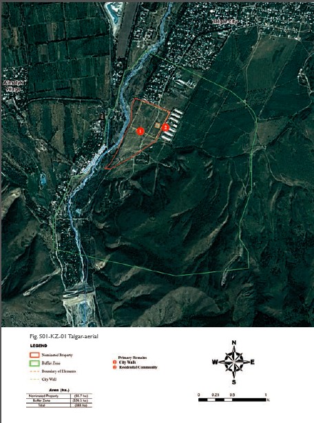
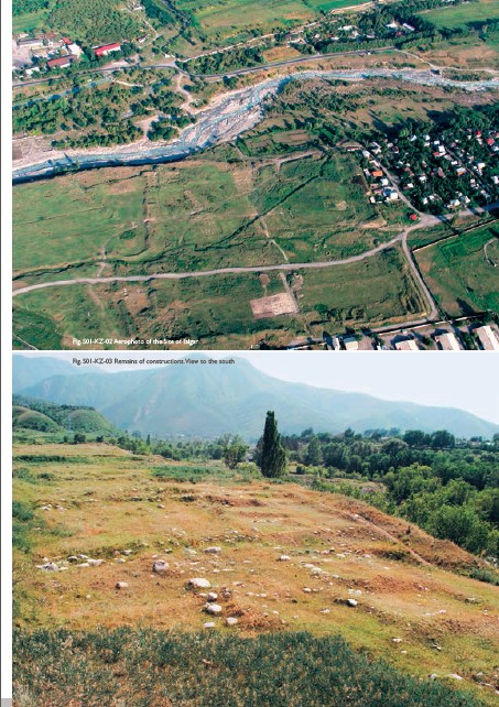
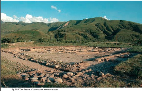
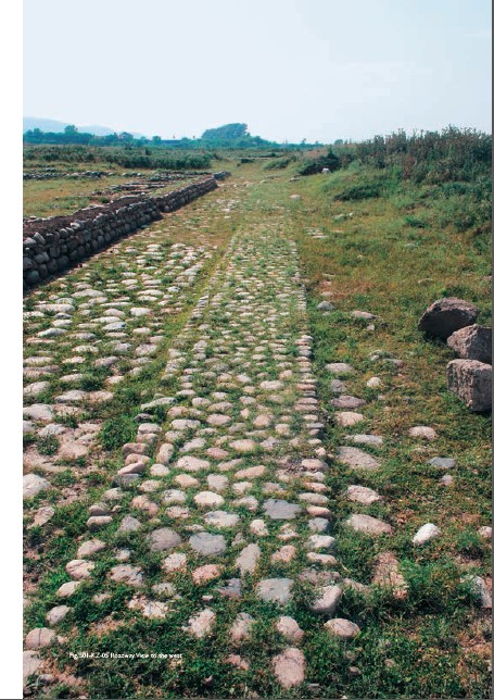
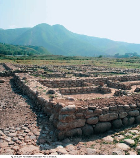
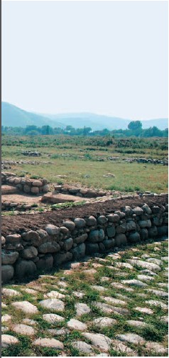
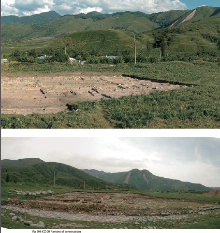
(1) Contribution to the Silk Roads' OUV The artifacts found in Talgar confirm the medieval trade links with other countries. The import production from China, Iran, India, and Japan was brought to the city by the Silk Roads route. There are collections of inscriptions on ceramics, stone and metal crafts in ancient Turkic, Orkhon alphabet, Chinese and Kidan languages, and Arabic inscriptions. Talgar is identified with the medieval town Talhiz reported by an anonymous Persian source of the 10th century "Hudud al-Alam". The medieval geographer wrote about Talgar: "Its citizens are warlike, brave and valorous". (2) General Information Talgar settlement is located on the southern edge of Talgar, on the right bank of Talgar river, at the entrance to the gorge. The settlement represents a rectangular plot surrounded by a wall with towers at the corners and perimeter, and now is a slipped down rampart. Around the rampart there are traces of the ditch. The central part of the monument is a somewhat elevated above the total surface area, the corners oriented to the cardinal points. The size of its sides are: the northeastern - 300 m, northwestern – 298 m, southwestern – 280 m, southeastern – 302 m. The settlement is surrounded by a high defensive rampart, which a large part is already destroyed. Maximum height of the rampart in the southeastern corner is 4 m, the smallest one in the western part is about 1 m. On the perimeter of the ramparts there were located round towers at a distance of 20, 22, 30 meters from each other. From the southwestern side the settlement is fortified by the second outer rampart. Entrances are located opposite to each other in the middle of the wall. The streets that connect them divide the settlement into four parts. This is clearly evident in the current topography of the monument. During the excavations there were cleared cobbled streets, houses, grounds of yurts. Area of the town is 28 ha (9 hectares are surrounded by the walls). Around the central fortified part (citadel) of the settlement, on the area of about 20 hectares, there are traces of estate construction, the street network and remains of the irrigation system. Excavations revealed urbanized areas, neighborhoods, street network within the building and beyond, consisting of quarterly unit and combining 6 to 12 houses, connected by inner streets. The northwestern part of the citadel is completely flat, in the southeast there are many oval mounds elongated in plan, in height of 0.5-1 m. The street that connects the northwestern and southeastern gates of the city is destroyed, at present these entrances are connected to the modern road that crosses the settlement. Highway streets were paved with cobblestone, where came out trade stores. In the northeastern part of the city, near the northern gate of the city, the excavation revealed a complex of buildings, consisting of residential and business premises, a corridor and iwan. Also was revealed the character of urban dwelling - planning, interior and exterior, building materials. The peculiarities of Talgar dwellings concludes in the presence in the houses a large courtyard with outbuildings for livestock and remains of the yurt grounds that were used as living quarters in the summer time. Findings of the settlement are represented by pottery, bronze and iron articles. There are fragments of glass and porcelain. (3) Attributes Long-term studies of medieval Talgar allowed the scientists to collect and analyse a large stratum of material, indicating an outstanding interchange of human values. The discovery suggests the existence of artifacts in several religious communities: Christian, Buddhist, Manichean, and Islamic. As an example, the find statues of Buddha sitting in ivory, a large number of pottery and bronze, richly decorated with inscriptions in Arabic, and the benevolent nature of the Koran, a ceramic lamp featuring crosses, copper cross-suspension, as well as terracotta figurines of animals indirectly indicating the existence of Shamanism in an urban environment, along with the listed religious trends. On the territory of Talgar was found a large number of articles describing the city as one of the key centers of trade between the Far and Middle East, as well as throughout Central Asia. The objects of the Middle East imports include such products as Chinese ivory chopsticks. Findings constitute an important collection of imported pottery and porcelain with traditional Chinese imports topic. A subject of interest is a piece of earthenware bowl. Judging by the opinion of experts from China and Japan, the bowl was made in Japan in the 12th – early 13th century. Among the Chinese and Qidan products there are products with hieroglyphic inscriptions. In the import of the Middle East and China an important role plays a bronze mirror, the other side of which is decorated with typical motifs of the regional production. Numerous brass and bronze art products – import – shows Talgar’s connection with the Iran-Caucasian and Central Asian centers and dates back to the 11th – early 13th century. As the export these products were brought to the Eastern Europe. During the excavation of Talgar was found series of things, the origin of which is undoubtedly related to India and demonstrates another direction in trade and cultural links. To these findings refer chess pieces made of ivory. To ensure the safety of trade, as well as the city's population, Talgar was surrounded by a wall and perimeter towers from four sides. The internal layout and improvement: four entry, located in the central part of the walls, connected by cobbled main streets which divided the territory of the settlement into four equal parts; dispensation of trade premises of iwan type with the location of the open side to the street, a water pipeline – all this is an evidence of the maintenance system of trade in Talgar. Talgar isknown as a center of blacksmith. Development of iron industry and blacksmith was one of the main attractions for the merchants to Talgar and strengthening trade relations between the regions. Revealing the fact of production of cast iron and damask steel by medieval steel-workers of Talgar reflects not only the high technological skills, but also the region's links with the Jurchens (Far East). The principle of combining housing with a yard-pen, typical for the nomads transiting to a settled life, suggests that the medieval tradition of the nomadic way of life preserved in the settled and urban spheres of the Ili Valley. It also confirms the fact of the combination of the stationary housing and yurts. The study of medieval dwellings of Talgar allows us to trace the processes of formation of permanent settlements and cities in areas with a predominantly pastoral direction of the economy. The architecture and construction are marked with original features, in many ways defined by local building materials, climate and the dynamics of economical development: a widespread use of stone in construction due to the abundance of this material; harsh climate forced to deepen housing in the ground, and a large yard is due to a high proportion of cattle breeding in the farm of Talgar residents. Probably the irrigation for the 8th – 10th centuries based on the use of fast mountain rivers by means of output the channels and devices of the headworks. Highway Western Europe-Western China lies in immediate proximity to Talgar microregion. This fact is irrefutable evidence that the transcontinental route has exactly the same direction of the Tian Shan Corridor of ancient Silk Roads.
|
 |Archiver|小黑屋|丝路遗产丝绸之路:长安天山廊道的路网
( 陕ICP备07011065号-3 )
|Archiver|小黑屋|丝路遗产丝绸之路:长安天山廊道的路网
( 陕ICP备07011065号-3 )
GMT+8, 2024-4-27 03:19 , Processed in 0.196026 second(s), 20 queries .
Powered by Discuz! X3.5
© 2001-2024 Discuz! Team.