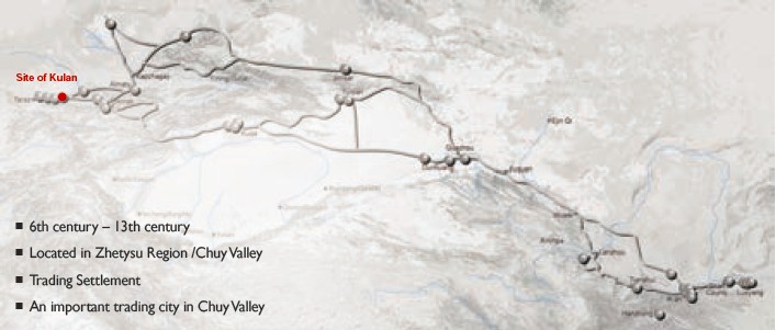
(1) Contribution to the Silk Roads' OUV The Kulan city is known from the written
sources relating to the 8th – 13th centuries. In routing guide of Chinese pilgrim Zhang Qian and
in the history of a dynasty of Tan it is mentioned under the name of
"Tzuilan’". In the 9th – 10th centuries, the Arabian authors describing the cities that
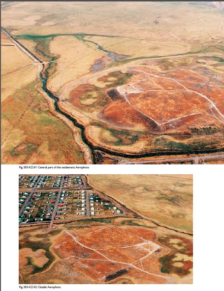
located on a line of the Silk Roads, mentioned Kulan. (2) General Information Kulan is a set of non-contemporaneous sites
located in the village and around. On the territory of the settlement, surrounded
by long walls, there are dozens of hills, which are the remains of castles and
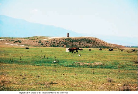
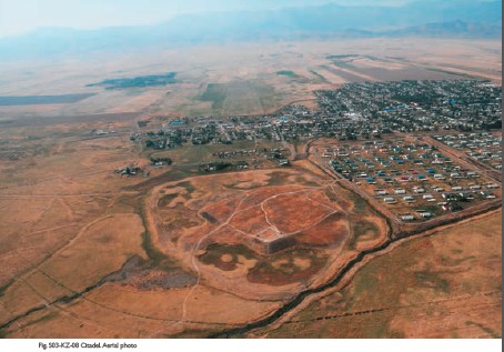
estates. Central fortress located 1.5 km northeast from the village. In the
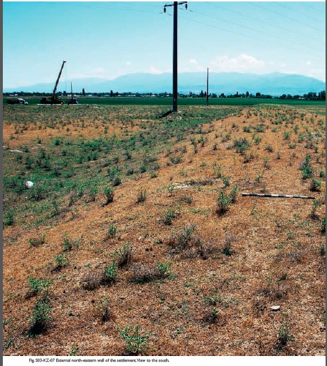
topography of the settlement can be traced citadel, shakhristan and unfortified
rabad tracks from the east. Outside the site is surrounded by a moat, has
preserved a depth of about 1 m and a width of 15 m. To the ancient settlement
adjoined rural districts with an area of 12-15m, surrounded by rampart. Citadel
of the 7th – 8th, 9th –
10th, 11th – 12th centuries is high, up to 7-8 m hill with a platform on top.
All corners of the citadel are fortified by the towers, the remains of which
can be clearly seen in the form of protuberance rounded elevations. Shakhristan
is a flat rectangular mound, with the length of 320 meters from north to south
and 300 meters from east to west. It is surrounded by a wall, preserved to a
height of 4-5 m. Corners of the walls are reinforced by round towers, in addition,
each of the parties in approximately 30-35 m had round towers, and ruggedness
of which is raised above the general level of the walls on the 0.5 - 1.5 m. Lugovoye
A (7th – 8th centuries; 10th century) is a hill in the form of a truncated
pyramid – "tepe with the square", which rises above the general
surface by 5 m. The mound at the base has dimensions of 40 × 30 m and by
all the sides is surrounded by heavily slipped down wall made of pakhsa.
Quadrangle walls oriented to the cardinal points. Its eastern side which is
preserved to a height is of 2 meters, is 30 m, southern - 35 m, western - 30 m
and northern - 40 m. The entrance to the castle was in the middle of the
northern wall. From the southeastern, northeastern and northwestern sides of
tepe there are three domed hill in height of 3-3.5 m. They are probably the
remains of the towers. Archaeological excavations fully disclosed the central
building, which had "comb" plan, typical for early medieval castles
in Central Asia and Kazakhstan. The castle consisted of seven rooms. In the
construction of Lugovoye A castle there can be traced two construction periods:
in the first period six sections had box arches, one was covered by the dome,
which was based on four corner trumpet arch-step form. The premises walls were
built of wattle and daub blocks and mud bricks in the technique of combined
masonry and had arched walkways. The premises walls were covered with a thick
layer of clay plaster and then whitewashed with alabaster. The floor was wattle
and daub, covered with a layer of coating. The second period of life of the
castle is characterized by significant rearrangements: all premises became
isolated, arch passages were bricked up, the new ones were dome in the exterior
walls, and each room had its way out into the yard. New floor level rose by
almost a meter. Floors were not daubed – it was replaced by
leveled and compacted debris. Walls, as before, were plastered and whitened
with alabaster. The walls of the courtyard are made of massive pakhsa blocks. Lugovoye B (7th – 8th
centuries) is located 3.5 km south from the settlement. The hill is 5 m high,
the size of the base on the east-west is 25 m, north-south is 20 m. At the top
of the hill there is an oval space, extended by 15m from east to west and 10 m
from north to south. There were found the remains of the estate. Lugovoye B is
the remains of a rural estate. In one of its premises there was a workshop for
processing grapes. The workshop consisted of wine pressing squares,
well-reservoirs and juice collecting vats. The internal surface of tanks and
wine presses was faced with pebble and covered with a thick layer of alabaster.
Three vats connected with each other by runners and with a well-reservoir – by pottery
tile. Two segments of pipe with flared mouths are connected so that the narrow
end of the first enters the second one. The junction of pipes is reinforced
with clutch of pieces of broken hum. Pottery from excavations of Lugovoye B is
widely represented by fragments of stucco hum (which 65% of all the dishes),
fragments of stucco boilers, heavy machine mugs and jugs. Findings attributed
to the 7th –
8th centuries. This dating is confirmed by the fact that the hum
of Lugovoye B has a close resemblance to the hums of Penjikent 7th – 8th
centuries. Pitchers in the workshop are mainly of two types: large aquifers of
manual molding and dining with a drain and without it. This type of pitchers in
Zhetysu dates back to 7-8 centuries. Lugovoe B (6th – 8th
centuries) is located 1.9 km to the southeast from the citadel. There were
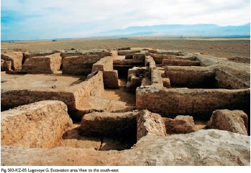
carried out no archaeological investigations at the site. Lugovoye G (7th – 12th
centuries) is located 2.8 km to the southeast from the central ruins of the
settlement, on the territory surrounded by a long wall. In topography of
Lugovoye G there is a central part of quadrangular shaped hill with the base
size of 45 x 40.5 m, 5 m high and the adjoining area (50 × 70 m). The
wall surrounding the courtyard preserved to a height of 1.5 - 2 m. In the
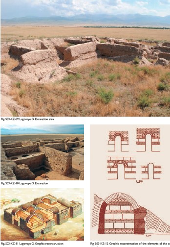
center of the courtyard traced pits of two howzes. Lugovoye G is a country palace complex of
Kulan. The palace is a monumental one-floor building of centric plan,
consisting of a large number of premises with iwans arranged around a square
courtyard, paved with slabs of burgundy sandstone. Entrance to the yard was
through a corridor. The particular interest represents the carved pieces, which
decorated the walls of the central hall and the entrance corridor. Also found
terracotta figurines of people, birds, and also heads of the nobility. Among the
elements of the ornament, which dominated here were medallions, rosettes,
palmettes, grapes shoots with bunches and leaves, islimi, pearls, that is, the
same motifs that present in the carving of Kulan. The similarity is in the fact
that the pieces are also tinted with white, yellow, red and blue. In the
topics, we should note fragments of images of wolf and deer. Lugovoye D (10th – 12th
centuries) was a mound in height of 2.5 m, oval in the plan, stretches from
north to south at 36 m, in the transverse direction is at 30 m. From the north
and south by low ramparts it was connected with the neighboring hills. In the
northern part of the hill were found two rooms. Both are extended through the
long axis to the west-east. The centre of construction is a hill with remains
of the hearths and bottoms full with gold, it was a fire temple. Tortkul Karakat (7th – 9th
centuries) is located 500 m to the north from Karakat village. Tortkul
represents elevated square platform. The walls oriented to the cardinal points.
At the corners preserved the remains of the towers with a diameter of 10-15 m.
Southeastern part of tortkul is fully excavated by bulldozers. Northwestern
corner with the tower is cut by highway Kulan - Karakat. Burial mound (Early Iron Age) located 6 km
northwest from the village Kulan, at the southern outskirts of Lugovoye
station. The burial consists of seven kurgans. Diameters of kurgans are 18-44 m
and height is 0.5-2.5 m. The kurgans are located haphazardly. In the western
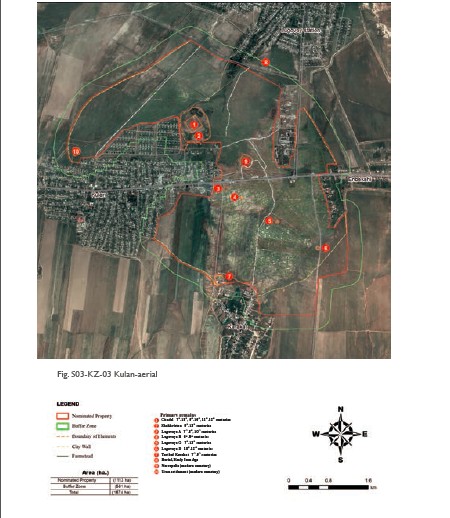
part of the settlement in the western city wall there was Usun settlement. The
results of investigation demonstrated the core values of the settlement - areas
of the planning structure. The main planning core is represented by the citadel
and shakhristan; Castle Lugovoye A, country palace Lugovoye G, estate Lugovoye
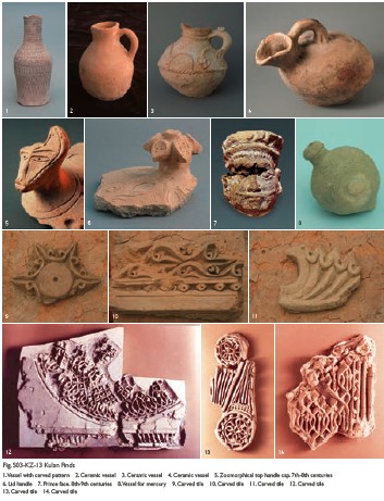
D; historical protective ramparts of the settlement, surrounding the neighbourhood. (3) Attributes There were found Zoroastrian fire temple,
cult ceramics (lamps) related to Zoroastrianism. Arab geographer al- Maqdisi
characterizes Kulan as “fortified city, the cathedral mosque is in it (Medina), it became
already empty. It is not great on Taraz road”. Found glazed
ceramics with inscriptions in Arabic, indicating the semination of Islam, finds
of Ancient Stone Sculpture (balbals) is an evidence of Tengrianism and
Shamanism. The city, therefore, was the meeting point of religions, values,
which were distributed among the citizens. Sogdian merchants were active
participants in an international trade, Sogdian colonies, composed of merchants
and farmers, have played an important role in the political, economic and cultural
life of the ancient Turkic states. As evidenced by written records, in the
cities of Zhetysu there were Sogdian diasporas, number of cities was based by
the Sogdians. Analyses of archaeological materials clearly distinguish between
two cultural complexes – old Turkic and Sogdian, their mutual development and enrichment. Archaeological
excavations conducted on the site, revealed a unique architectural complex of
the country palace of the rulers of the city. It is a poly-bedroom construction
of a palace type, the walls of the complex of input spaces were carved on the
piece (plaster), which formed the panel of ornamental plants and geometric motifs,
as images of people and animals in the style of carving, figurines of people -
the bulk head of nobility in the face and in profile once mounted in the plane
of the ornamental panels. The head, that preserved better than others (5.7 × 5 cm) has a
broad flat face, eyes hollows are shallow, flattened cheekbones, flattened
noses with wide nostrils, eyes are bulging, almond shaped, eyelids are marked;
eyebrows almost meet at the bridge of the nose, right hand is raised up; over the
pushed forward lips there are depicted moustache placed horizontally, pointed
at the ends, round chin, elongated ears with earrings. From the head-dress that
crowns the head preserved only the left side. In the lower part there is a
horizontal line, from which rise the teeth or folds, located at the top. From
under the hat down over the forehead there is a fringe of straight hair.
Similar to that there are two more heads. Despite the similarities in the modeling,
all the heads, of course, refer to the images of different people. Sculptor
managed to convey the personality of the character of each personage. Analogies
to this carved piece of Kulan are diverse and broad. This is the famous
monuments of Central Asia and, above all, Afrasiab where "Samanid palace"
was excavated and also a magnificent building with stucco carvings of the 9th – 10th
centuries, as well as the monuments of the Middle East, in particular, Samarra,
Fustat, Mshatty. The art of carving on a piece spread along the Silk Roads at a
great distance and reflects the cultural traditions of various countries and
peoples. The settlement is located in the foothills
in the fertile lands, which is watered by a number of mountain streams, including
the largest one – Karakat. To the north there is a steppe turning into sands of
Moyinkum desert. In the Kyrgyz Alatau mountain range there are passes through which
it is easy to get into the Talas valley, and thence to Fergana. The city had
strong fortifications, citadel, foothill rural area with the walls with the
towers and fortified entrances. There was a bazaar in the city, near the
southern contours of the wall of the district there was located a caravanserai
(its remains are preserved). Key position of the city, two routes of the Silk
Roads – the foothill and steppe – all this provided
the trade during the period of existence of the city from the 7th to the 12th
century. Arabic official of the first half of the 10th century, Qudaamah ibn
Jafar, describing the road from the city of Taraz to Kulan, wrote: "From
Dzhuvikat to Taraz city on pastures and populated area it is 2 farsakhs. From
the city of Taraz to the Lower Barskhan is 3 farsakhs. From the Lower Barskhan
to Kasribas is 2 farsakhs. To the right there are mountains, and to the left
there is sand, it is a warm place, and this is the beginning of Karluks. There
is sand between Taraz and Kulan from the northern side, and after sand there is
a desert of sand and pebbles, there are echidnas, and it goes to the borders of
Kimaks. From Kasribas to Kulshub it is 4 farsakhs, and it is the same as
Kasribas, to the right of it there is a mountain, where there are a lot of fruits,
clover, and mountain vegetables. From Kulshub to Kulan in the same way it is 4
farsakhs. In total from the city of Taraz to Kulan it is 14 farsakhs by desert,
known as Kulan, it is as set above. Qudaamah’s report corresponds
to the modern landscape and the nature of the site on the Silk Road from Taraz
to Kulan. There are foothills and mountains with pasture to the north if we
move to East, and sandy desert Moiynkum to the north, where in the10th – mid. of the
11th century grazed herds of onagers. Moreover, the desert in some places gets
very close to the foothills, for example as in the region of the Akyrtobe
station, located in the middle of the road section between Taraz and Kulan. Caravan
route passed in the foothills zone and to the north – in the
steppe zone. Foothill zone with numerous mountain streams and springs were used
in spring, summer and autumn; in the steppe it was easier to move in winter
time, and where there was little snow – it was blown by
wind. Kulan is located between two sites, occupying agricultural districts
along with the suitable landholdings. Kulan developed in the area of mountain
passes in Kyrgyz Alatau through which the road stretched to the Talas valley.
To the north along the river Kuragaty the section of the road lead to the
steppe in the lower reaches of the Chu river and further to the steppes of
Central Kazakhstan. Through this place passed the livestock drove to the summer
mountain pastures from steppe in spring and summer, and in autumn the
cattle-breeders used to come back to the winter pastures into a sandy desert.
Kulan is located in the area ideal for the meeting of nomads and farmers, and
it was the area where met the city and steppe, the townspeople and
cattle-breeders. In 1928-1930 to the north from Lugovoye village was run a
famous railway Turksib (Turkestan - Siberia), then in 50s from this railway
moved away a branch to China to the station Alashankou (Railway-Friendship Road),
and in 2012 was built another branch to China near Almaty–Zhetygen–Khorgos.
Thus the Silk Roads remains in a system of transport communications. As before,
through the area of Kulan were driven small cattle and herds of horses from
winter pastures in Moyin-Kums to the mountain pastures, its most famous one is
the river valley of Karakystak. There is still a contact between the breeders,
farmers and townspeople but in the new conditions. Preserved ancient holidays of
the breeders timed to the beginning and end of these modern nomads. Now they
are called The Day of the Shepherd, popular among the population, as well as the
landowners’ celebration of The Harvest Day. In the region, along with Islam,
Christianity, there are always representatives of Shamanism (baksy). Shamanism which
was almost extinct by the end of the 20th century is now reviving and getting
adherents. Mainly the baksy practice traditional medicine and rituals that are
used for treatment of ill. Now is being built a highway Western China –
Western Europe, passing to the north from Kulan, 300 meters far from the
citadel of Lugovoye settlement, repeating the steppe part of the Silk Road.
|
 |Archiver|小黑屋|丝路遗产丝绸之路:长安天山廊道的路网
( 陕ICP备07011065号-3 )
|Archiver|小黑屋|丝路遗产丝绸之路:长安天山廊道的路网
( 陕ICP备07011065号-3 )
GMT+8, 2025-7-12 18:37 , Processed in 0.277161 second(s), 19 queries .
Powered by Discuz! X3.5
© 2001-2024 Discuz! Team.