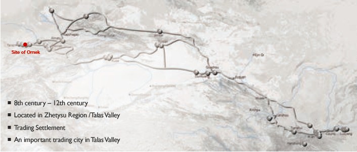
(1) Contribution to the Silk Roads' OUV Ornek is Kulshub arised on the Silk Road as
a Turk rate, which converted into a city and became a bridge of human values
interchange of the nomads and settlers. (2) General Information Ornek is located 8 km south from the
village Ornek, on the banks of rivers Altynsu and Shybyndy, in Sulutor gorge.
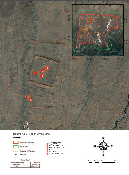
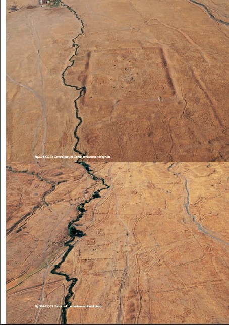
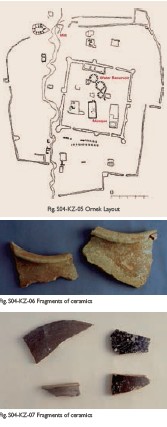
The central part of the settlement is a quadrangular court, with the corners
oriented to the cardinal points. The site area along the ridge of the surrounding
it rampart is 155 × 160 m. At the corners and along the perimeter of walls
there are hilly 31 towers. In each of the four sides can be traced entries in
the form of breaks in the ramparts. From the entries were lead the roads that
crossed in the center of the settlement. Visible remnants of ancient buildings
is a rectangular building in the center of the settlement, its size is
approximately 50 × 20 m, denoted by separate stone laying outs, three
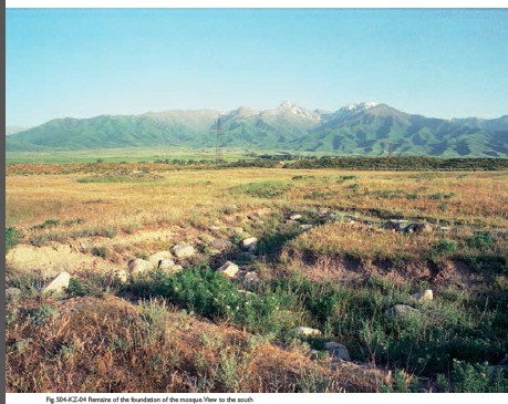
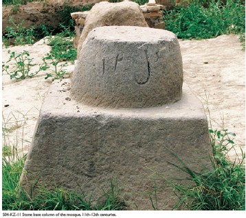
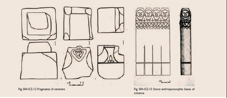
howz-reservoirs, as well as the remains of barracks type buildings. Mosque of
the 10th – 12th centuries located in the central part of the settlement is a
rectangular building in size of 40 × 20m on the outer perimeter of the walls,
oriented to the cardinal points. Base of the walls are made of stone boulders.
Clearing of the bases showed that the wall itself was wattle and daub, with
width of about 1 m. On the surface of the floor was found a system of stone
base of the columns. Two of them are the blocks carved out of massive boulders.
The first is decorated on one side by the slot ornament made by a double line.
There is a figure in the form of stem of vase, which shows a list with two
tendrils extending from the heft. The second - trapezoidal block, on two facets
there are carved images of anthropomorphic creatures. Third base is in the form
of a two-stage unit. Two more excavations were laid at hilly areas of the
parts, formed with stone boulders, which revealed the remains of small
residential buildings, its grounds were made of boulders. They were divided
inside into two parts by the partition of the smaller stones. Ceramics of the
constructions is typical for the period of the 10th -12th centuries. Another excavation
was laid on a separate estate, at the south of the settlement. It consisted of
a living room and yard. The house was located in the northeastern part of the estate,
which consists of living area, patio and space for livestock. The base of the
home walls to a height of 1 m were made of stone boulders, larger at the bottom
and sealed with clay mortar. The floors in the living rooms lined with
cobblestones. There were sufas, hearths, tandoors and bins in the premises. The
study of the topography of the Ornek site and excavations give an image of the
center of the settlement and trade. At the same time, the powerful
fortifications, mosque, rich mausoleum – all this is an evidence that the site
is the remains of the city, which was formed on the basis of the rates of
nomadic rulers. Mausoleum with burials of the 10th – 12th centuries located
over the pottery in the same hill. Mausoleum was used for collective burial, made
in the vaults of mud bricks. The vaults were of oval form up to 2 m. From above
they were covered by two rows of bricks set on edge, forming a “firtree”. Inside the
eastern wall cleared up three vaults. Outside the eastern wall of the mausoleum
was adjoined by two more vaults. The overlap of the mausoleum was flat; its remains
are cleared up on the floor. Near the southern wall there were charred block of
the wooden decor of the mausoleum - one full and a fragment. The boards were
covered with carved vegetable and geometric ornament, executed in two ways. In
the arch there is a repeated motif of semipalmette. Arch is inscribed into a
rectangular area, in the corners of which there are depicted vegetable curls.
Lower plan is a heartshaped with a rounded top and antennae in the corners of a
rectangular field. In the study of the stratigraphy of the excavation revealed
that the mausoleum and tombs destroyed the pottery that was below: on the floor
area found the upper part of a millstone with pits, grooves on the surface, a
large number of unburned pottery shards. During the excavations of the workshop
was collected pottery, typical for the southwestern Zhetysu of Karluk period of
the 8th – 9th centuries. Glazed ceramics is represented by chirag with faceted
body and a long spout. It is covered with a dull, dark green glaze. Collected
some fragments of bowls with green glaze and engraving. Also found a bowl
covered with a transparent glaze over white engobe and underglazed engraving of
epigraphic character. During the excavation were discovered iron-edged knives
with handle up to 10 cm, single-edged blade fragment, the total length of which
was not less than 25 cm, loop grip of iron pot and a fragment of the iron plate
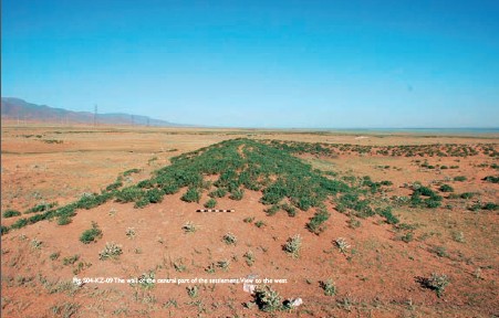
bracelet. The outer wall is a rectangle with the size of the parties: the
southwestern – 330 m, northwestern – 290, the northeastern – 300, the
southeastern one consists of two serried obtuse angle sections of 200 and 160
meters in the middle of the northeastern part of the wall there is traced a
break – the remains of passage. Rectangular, square and irregular plots, which
are separated from each other with stone boulders, located around the
fortification, mainly behind the outer wall to south and southeast along the Solutor
gorge. An array of these areas stretches along the banks of Solutor up to 4 km
and in width – up to 1.2km. The plots, situated around, have common fence. Plot
sizes range from 250-300 to 1.000-2.000 m. The total area of it, therefore, is
about 500 hectares. Fences overlap the external and internal walls and ramparts
of the settlement, it follows that the ramparts were built later. (3) Attributes Archaeological materials indicate that this
city on the Silk Road, on the segment of Tian Shan corridor was a place of
outstanding interchange of human values. It is here in the foothills of the
Tian-Shan, in a place of passage of the routes of the Silk Road, met the
representatives of the urban and nomadic civilizations, each of which professed
values of their culture, lifestyle and mentality. Exchange of values happened
in this city, which was formed on the basis of a nomadic headquarter. Settled
in the town former nomads joined the occupations in trade, crafts and
agriculture. The city controlled the way of seasonal migrations of the
cattle-breeders from the summer to winter pastures and back again. Near the
settlement there is a necropolis of the nomads. A catalyst for the development
of the former headquarters and turning it into a city was the interchange of
human values. In the area of the settlement there were spring-autumn pastures
where nomads cultivated land and grew crops (millet, wheat). In the topography
of the suburban part of the settlement, located along the mountain streams,
there were numerous plots of fields enclosed by stone walls, with fixed dwellings
settled on the land of nomads. In the center of a rectangular form of
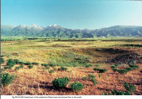
headquarter located Karluk nobles houses and guard barracks, howzes – water
reservoirs, and was one of the earliest mosque of pillar type on the territory.
Near the headquarters the archaeologists discovered workshops of the potters,
craftsmen of burnt bricks for the building needs of the population. The settlement
Ornek is Kulshub settlement, originated on the Silk Road as a Turkic
headquarter, which evolved into the city, became a bridge of interchange of
human values of the nomads and farmers. The city's population was heterogeneous
in ethnic and confessional terms. Some of them, judging by the pottery (ritual
vessels and lamps), worshiped Zoroastrianism, they were Sogdians. Settled Turks
were Shamanists and Tengrians. In the 9th – 10th centuries asserted
Islam, which is evidenced by the mosque of pillar type of the 10th – 12th
centuries that was excavated and studied, and also Muslim mausoleum of the 11th
century with the burials of Muslim rites. Locating on the Silk Road the city was the
center of international and local trade. During excavations here was found
Sogdian (Central Asian) ceramics, which is called by archaeologists as the
Turkic-Sogdian, pottery with Arabic epigraphic ornament. Near the Sulutor gorge
were found the remains of stonemason workshop where revealed stone billets for
sculpture and the sculpture itself (balbals). The central part of the settlement is
situated on the river Altynsu (Golden water) was fortified by wattle and daub (pakhsa)
wall with towers at the corners. Inside there was a mosque, construction of
barrack type, to the north from the wall was located a pottery. The great
extent of territory along the river was occupied by the plots of land (fields),
enclosed by stone walls. On the site there was a house consisting of one or
more premises. It is important that in the central part, on the river Altynsu
cleared the remains of the 17 water mills. Grain and flour were needed for
passing caravans, as well as bread and tissues, as evidenced by written
records, were the main subjects of the demand of the nomads. And yet in the
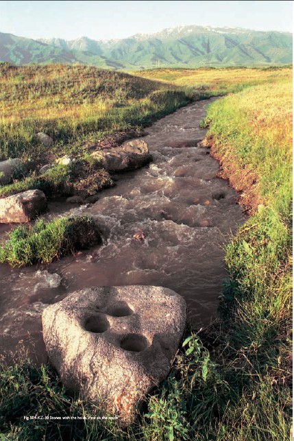
mainstream of the river Altynsu found more than 10 large stones, which go
outside of their plane. On the upper floors of stone there were arranged wells
that served to trap gold dust during the rise of water in the river or when snow
glaciers melted in summer. Ornek was the only city where the gold was extracted
in this way. The settlement Ornek, which corresponds to
Kulshub, is located in the foothills of the Kyrgyz Alatau, on the upper foothills
of the Silk Road route in the Sulutor gorge on which there was a road to the
summer mountain pastures, where in winter time raised nomads with their herds
of cattle. At the end of summer they used to climb down to the mountains and
move further into the Moyinkum desert on winter pastures. Qudamaah ibn Jarar, who lived in the 10th
century, in his book “Kitab al Kharadzha” describing the land trade route from Taraz to Kulan, wrote: “From
Kasribas to Kulshub there are 4 farsakhs, and it is the same as Kasribas, to
the right there is a mountain where there are a lot of fruits, clover and
mountain vegetables. From Kulshub to Kulan it is same - 4 farsakhs. “Ornek
ancient settlement which corresponds to Kulshub, is located in the foothills of
the Kyrgyz Alatau, the upper piedmont the Silk Road in the gorge of Sulutor
where there passed a road to summer mountain pastures, which were raised in the
summer of nomads with their herds of cattle. At the end of the summer they get
down to the foothills and moved further into the desert of Moyun Kum to winter
pastures. In the area of Ornek the desert comes almost close to the foothills,
therefore Ornek was a place where there was a contact between the nomads and
farmers, steppes and cities - contacts of the two great cultures. From the
earliest time in Zhetysu where Ornek and other settlements of the Tian Shan
corridor are located, celebrated symbiosis of settled and nomadic tribes and
peoples, such as Saka, Wusuns, the ancient Turks, Sogdians. City and steppe were
not two antagonistic worlds, but two branches of a number of states, their
economic base. Flourish of the cities, including those located on the Great
Silk Road, is largely due the interaction of nomads, farmers and city dwellers,
nomads’ settling down. They brought in a lot of steppe elements in an urban
culture and it is here in Zhetysu, formed a kind of urban culture and cities. Zhetysu
where situated Ornek and other cities of Tian Shan corridor, were marked by the
symbiosis of the settled and nomadic tribes and nations, such as Saka, Usun,
ancient Turks, Sogdians. City and steppe were not two antagonistic worlds, but
two branches of economy of many states, their economic base. Rise of cities,
including those situated on the Silk Roads, is mainly related to the interaction
of nomads, farmers and city dwellers, nomads’ settling down. They brought in
urban culture a lot of steppe elements and exactly here in Zhetysu, formed a kind
of urban culture and cities. Ornek, which was situated on the Silk Road,
nowadays continues to be a place (now village) on the road Taraz - Ornek -
Kulan, foothill road, which follows the route of the Silk Road in the Middle
Ages, as well as roadpost path of pre-revolutionary Russia. So far, in the neighboring
to Ornek Podgornoye village preserved the post office of the 19th – early 20th
century. At 3 km to the north from Ornek there is a railway, built in 1928- 1930.
Turksib (Turkestan-Siberian Railway), from which there are branches that go to
China till Alashankou and further China Railway leads to Urumqi and Beijing. Another direction is from the Zhetygen
station (40km northeast of Almaty) to Khorgos in China. Ornek preserves the
ancient tradition and remains an important center of transport communications.
Solutor Valley, where the settlement Ornek is situated, is a place where from
the earliest times passed nomads of trade routes to the summer roam in the
mountains from Moiynkum desert and back. So far, they serve as routes of
livestock, cattle-breeders still put here yurts, and at the same time in the
gorge there are arrays of fields of farmers on the coast, accumulated to
agricultural areas of the medieval farmers who had settled among the nomads.
Survived to this day memorable landmark rocks (e.g., step-stone altar), around
which people gathered on holidays, as the day of Chaban. As in antiquity, there
are still arranged bayga (racing horses), sports national competitions, and traditional
music is performed.
|
 |Archiver|小黑屋|丝路遗产丝绸之路:长安天山廊道的路网
( 陕ICP备07011065号-3 )
|Archiver|小黑屋|丝路遗产丝绸之路:长安天山廊道的路网
( 陕ICP备07011065号-3 )
GMT+8, 2025-7-2 12:27 , Processed in 0.322607 second(s), 20 queries .
Powered by Discuz! X3.5
© 2001-2024 Discuz! Team.