The
Archaeological chronicle of the South Gate of The Site of the Beiting City in
2016 In
the fourteenth year of the Tang Zhenguan period (640 A.D.), Emperor Tai Zong of
the Tang Dynasty instituted the “Tingzhou Prefecture” in the North Slope of the
East Tianshan Mountains where the Site of Beiting City used to locate. In the
second year of Chang’an period (702 A.D.) when the Empress Wu Zetian was
reigning, the “Tingzhou Prefecture” was changed into “Protectorate General to
Pacify Beiting” to govern the northern grassland areas to Tianshan Mountains.
During this period, the area was in a great bustle of putting up installations
and buildings. The city was expanded and new Buddhist temples were built such
as “Ying Yun Tai Ning Temple”, “Gao Tai Temple” and “Long Xing Temple”. The
Site of the Beiting City and the “Xi Da Temple”, No. 5 temple and No. 6 temple
among it are probably the remains of the buildings in this period. The
fifth year of the Kaicheng period (840 A.D.) when Wen Zong of the Tang Dynasty
was reigning, the Uyghur people migrated from Orkhon river basin to the west, therefore
a part of them settled in the Beiting area, and they used the old city walls
and moat to protect themselves. When the Uyghur people were in Mobei, they
believed in Manichean, but in the seventh year of Xiantong (866 A.D.) after the
Qocho Uyghur Regime’s establishment, they began to convert to Buddhist. Nowadays,
people can still see the portraits of “Idiqut (the king of Qocho)”, “Zhangshi”
and “princess” in Xi Da Temple. In the sixth year of Zhizheng (1346 A.D.) when Hui
Zong of Yuan Dynasty was on the throne, the son of Tuheilutiemu'erhan was enthroned
and became Chagatai Khan. During the rule of Chagatai Khan, he launched the “holy
wars” in Beshbaliq and Qocho areas: wars and moat were ruined, the Buddhist
temples were destroyed, the Buddhist monks and nuns were killed and the
citizens were forced to serve Allah—the god of Islam. Beiting City became a
wasteland at that time. The
Beiting City was constituted by two cities—the inner city and the outer city. The
city walls are both rammed, and look similar. Each city has its own watchtowers
and turrets: in the outer city, there are twisted barbicans, and in the north
located some “Yang Ma Cheng” which is similar to the city walls as a barrier to
defend the enemies. Outside the city walls meanders through the moat. The
layout and constructions of the city can be considered as the model of the
spreading of constructing skills of the Central Plain in the western region of
China. The greatness, carefulness and rigour of the layout and construction
match the status of the city as a centre of central Asia grassland region and
also an important city for politics and military perfectly. From the
end of the 19th century to the latter half of the 20th
century, explorers and archaeological workers, in and out of China had and excavated
and done archaeological surveys to the ancient city for many times, and
different plans ,in details or general, have been drafted since then. 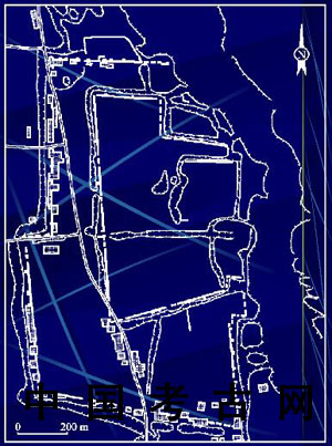 Picture 1. The map of the Site of Beiting by Xinjiang Team of the
archaeology department of Chinese Academy of Social Science, only the city
walls can be recognized, other buildings are no longer existed. According
to the archaeology data, the Beiting City are consisted of two cities. The
outer city is like an Irregular rectangle of which the north-south direction
line is longer. The perimeter of the outer city is about 4596 metres, and there
is a corn tower in each corner of the city wall. Outside the city wall are some
watchtowers, and on each side of the city, there is a city gate. By the north
side of the city wall lays a rectangle-like Yang Ma Cheng (170*117 metres) --a
kind of outer city wall; the inner city located in the middle-northeast of the
outer city and it’s about 3003 metres in perimeter. Each city has its own ditch
around the city. 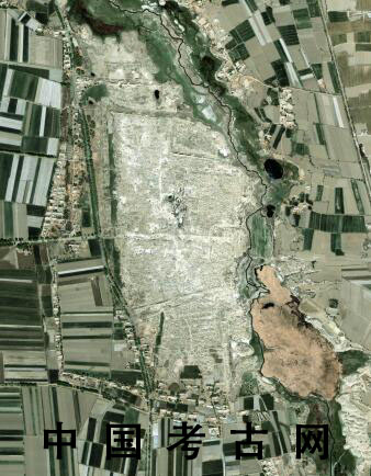 Picture
2. The aerial photo of the Site of Beiting City, 1985. On
July 16, 2016, Xinjiang Team of the archaeology department of Chinese Academy
of Social Science entered the Site of Beiting City and started their work
again, and this time, their workplace is the site of the south city gate and
the city walls around it. The purpose of this work is to clarify the time and
methods of the construction and also to find out whether these parts had been
repaired or expanded.
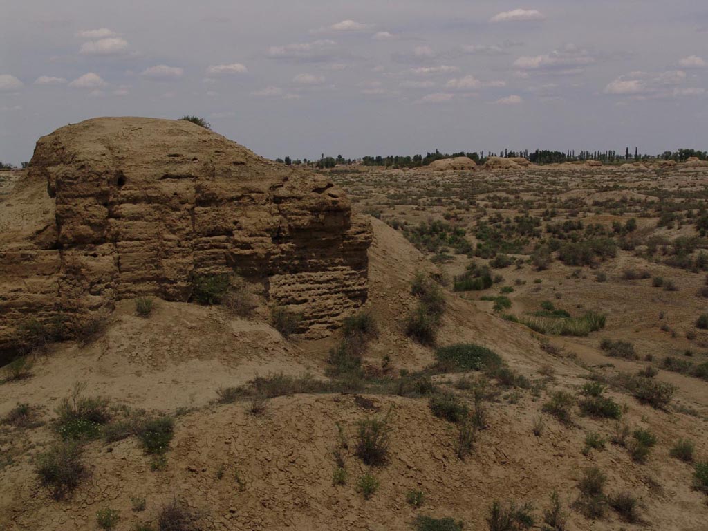
The
South City Gate is in the centre of the south city wall, but now, there is no
longer the gate but a huge hole in the wall and the gate has become a part of a
road. On each side of the road is a little platform, the distance between them
is about 15 metres. According to the ditch around the city wall, it can be
inferred that there was a barbican around the south city gate, and these two
platforms are the remaining of the barbican. 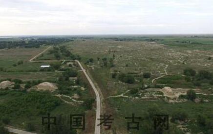 Picture 3. The location of the South City Gate and the current situation of the city (aerial photo South-north). 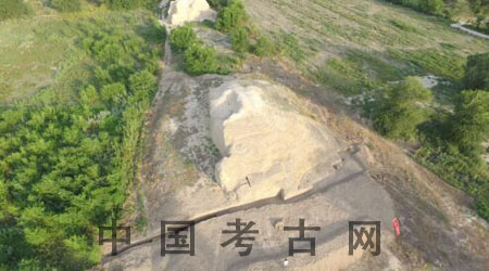 Picture 4. The area of the archaeological excavation (aerial photo, East-west) 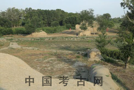 Picture
5. The platforms on the west side of the south gate—the remaining of the
barbican (East-west)  Picture
6. Archaeologist Jiang Zhongyi is deducting the map of the Beiting City During
the work, a trial trench has been discovered, it’s about 0.6-1.5 in depth,
starting from a watchtower, this trial trench goes along the watchtower and
leads to the ditch around the city. The profile of this trial trench shows a formation
line of the watchtower and city wall. Above the formation line is the layer
filled with rammed earth, the depth of stratum is about 6-10 centimetres, and
the colour of the earth is mostly yellow, some is gray or taupe (the reason is
the production area of the earth). From the continuity of the earth, the
building is supposed to be built in one time; the solum below the layer is gray
and mostly thick, the content of the soil is varied, and there are some ceramic
debris, chunk of the bricks and some crushed bones of the animals. Also, a coin
of Kaiyuan Tongbao is discovered somewhere under the gray soil. From these
signs, it can be inferred that the city wall was not built on the origin earth
according to some surveys but on the soil of the Tang Dynasty. 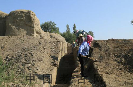 Picture
7. The trial trench under discovery (South-north) 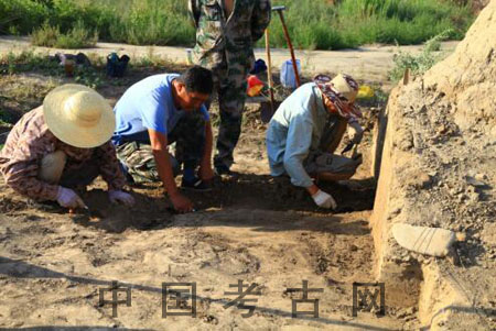 Picture
8. The rural labourers have mastered the skills of identifying the soil and
looking for the spot of tampering under the guidance of the archaeological team. 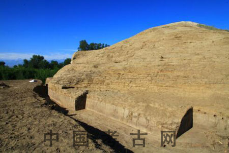 Picture
9. The northern part of the trial trench (North-south) 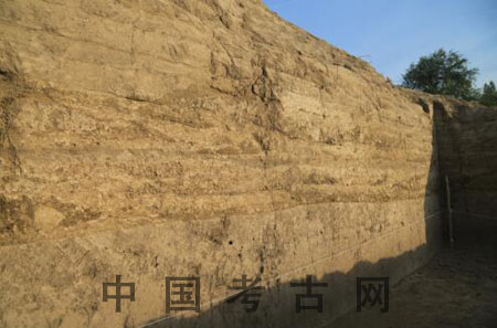 Picture
10. The earth layer of the Ma Mian (watchtower) on the trial trench 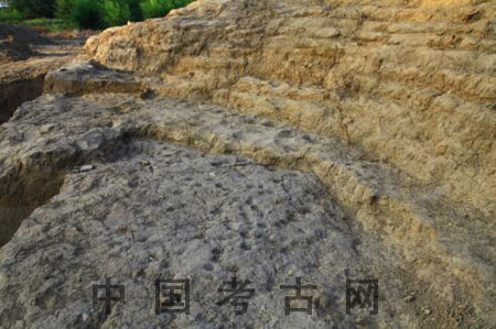 Picture
11. Tampered field and tampered spot 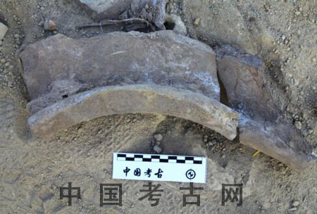 Picture
12. Ceramic debris discovered in the earth under Ma Mian 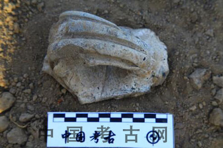 Picture
13. Ceramic debris discovered in the earth layer
of Tang Dynasty under Ma Mian 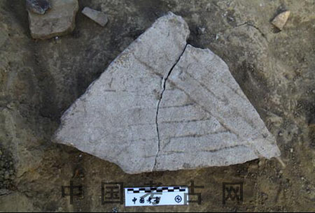 Picture
14. The remaining of the stone mill discovered in the earth layer of Tang
Dynasty under Ma Mian 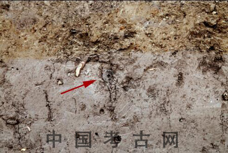 Picture
15. Kiayuan Tongbao discovered in the earth layer of Tang Dynasty under the
city wall 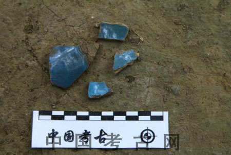 Picture
16. The relics of Jun porcelain discovered in the earth layer of Song Dynasty Outside
the city is a ditch goes around the city, between the city wall, Ma Mian and
the ditch, there is the sloping bench. The profile of the trial trench shows
that from the top to the bottom, there is the modern cumulose soil, modern road
bed soil, and the soil from Tang Dynasty. The soil under the sloping bench and
the edges of the ditch is cumulose soil, and under this layer is the mixed gray
soil of which some part is hard, and the texture of the soil is well organized,
some relics of jun porcelain spreading there. Below this layer is the gray soil
with the Ceramic debris of Tang Dynasty. Jiang Zhongyi, the 78 archaeologists
from the archaeology department of Chinese Academy of Social Science, thinks
these stratums are very meaningful, according to him, the soil with the Jun
porcelain is the road from Song Dynasty, it overlies the sloughed formation
stratums of Tang Dynasty. So it can be concluded that the buildings are built
before Song Dynasty, it’s more likely the construction of Tang Dynasty.
This
conclusion clarifies the year when the Beiting City was built which means, it
proofs directly that the constructions in the city are from Tang Dynasty. The
profile of the trial trench also shows that there was a road outside the city
in Tang Dynasty, and the road laid on the sloping bench ; when it came to Song
Dynasty, the road was moved to the edge of the ditch. 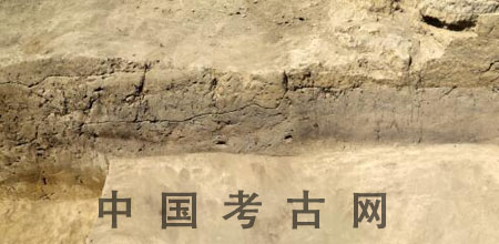 Picture
17. Part of the stratum of the city wall to the ditch 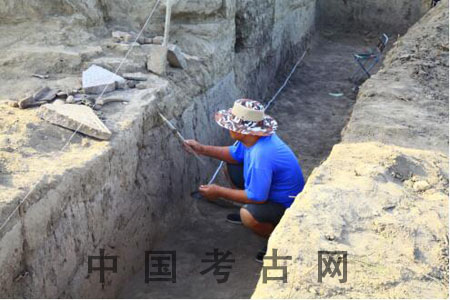 Picture
18. Expert Jiang Zhongyi is observing the stratum  Picture
19. Jiang Zhongyi is drawing the draft of the profile of the trial trench The
latest research shows that the south city gate of Beiting City and the city
wall were built firstly in Tang Dynasty, and the specific peirod of
construction can be inferred after the study of the discovered materials and
specimens. According to the layout of the stratum, it can be referred that when
the Uyghur of the Song Dynasty took control of the city, the city was in a good
condition, and they didn’t expand the city a lot, they just discarded the
sloping bench and built another road outside the city.
The
results of other researches also indicate that “Ren Mu” was used to build the
watchtowers, and the layouts of these constructions are popular in Tang
Dynasty. The layout and constructions of the city reflects the spreading of constructing
skills of the Central Plain in the western region of China. The
greatness, carefulness and rigour of the layout and construction match the
status of the city as a centre of central Asia grassland region and also an
important city for politics and military perfectly. In a
word, the Beiting City was a grand city of the western region of China, and the
layout and constructing skills of the city are all from the central plain. It
doesn’t only show the relationship between the city and the central authority,
but also shows the greatness of Tang Dynasty, and its scale shows the
importance of this city. The researches which have been done till now provides
great conditions for the following works: on one hand it shows how to protect
the remaining and relics; on the other hand, it makes it more possible to
reproduce the image of the grand city in Tang Dynasty. Though
this is the beginning of the exploring, yet it has already answered some of the
questions which have been confusing the world, such as: whether the whole
Beiting City was built in the same period (some believe that the inner city was
built during the Qocho Uyghur
Regime, and the outer city and other remaining are built in the Uyghur of the
Song Dynasty.). So far, it can be sure that the Site of Beiting City was built
in Tang Dynasty. The Site is the relic of the great city which rules the grand
grass region and the centre of the politics, military, economy and culture,
also the key joint of the Silk Road. This is only the tip of the iceberg, there
will be more information and materials discovered in the future as the research
goes on. 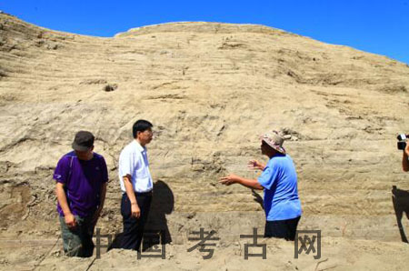 Picture
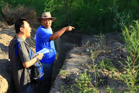
20. The county leadership is inspecting the workplace of the archaeology. 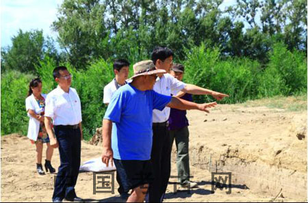 Picture
21. The county leadership is listening to the archaeological introducing Thanks
for the hard work of the archaeological team and the support of the Jimusa’er
county. The county party secretary Mr. Hao coordinated the work for the team
and went to the work place for many times. He cared about the archaeological
team a lot. Also, the journalists from Guangming Daily and Yaxin website
Xinjiang arrived to the archaeological site the first time around and did the
interviews immediately, thanks for their work. (Xinjiang Team of the
archaeology department of Chinese Academy of Social Science) |
 |Archiver|小黑屋|丝路遗产丝绸之路:长安天山廊道的路网
( 陕ICP备07011065号-3 )
|Archiver|小黑屋|丝路遗产丝绸之路:长安天山廊道的路网
( 陕ICP备07011065号-3 )
GMT+8, 2025-7-19 07:03 , Processed in 1.963988 second(s), 21 queries .
Powered by Discuz! X3.5
© 2001-2024 Discuz! Team.