遗产数据库
派肯特Poykent
Poykent
| Bukhara Region | 14 ha | 39o30' N; 63o50' E |
Name of individual Silk Roads component property: Poykent
Brief description of the component property:
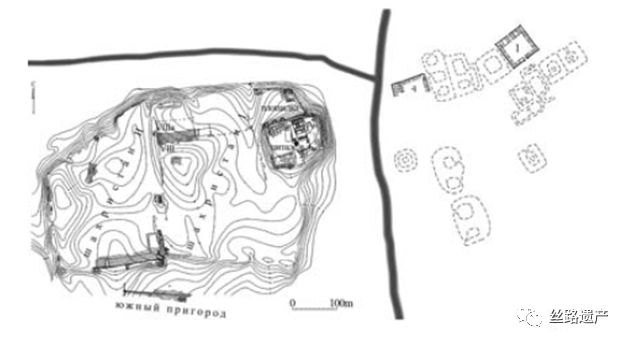
Poykent is located in the lower stream of Zarafshan River and was one of the largest cities of the oasis. The city was consisted of citadel, two sites of ancient settlement and rabod (suburb). According to the archaeological researches, this place was found as a small village in the IV century B.C. and later was transformed into fortress. At that period being as trading place, this city connected Southern countries (Bactria, India, Iran) with Northern countries (Front of Ural, Coast of Volga, Northern Caucus) and Poykent was one of the important military and trade centre of the Western borders of the Sogd. Due to the development of the Great Silk Road and joining with Poykent fortress have been found first and second sites of ancient settlement. Hence was found the city Poykent. According to Chinese chronicles, this city was under the "An" (Bukhara) kingdom and was the centre of "Bi" khanate. Also was noted that in Poykent was not khokim (governor), the city was ruled by traders' council and in full sense of the word the city was the republic in the VI-VII century. The scientists of Institute of Archaeology of Academy of Sciences of the Republic of Uzbekistan carrying out scientific researches in ruins of the city for a long times. As a result, Zoroastrian temples, palace and the mosque, built by IX century, and remnants of tower were found in citadel. In the inner part of city were discovered defensive walls, gate, roads and remains of quarters (makhallas), while in outside of rabads the city - potter centers and caravanserais. According to the researchers, due to inaccessibility of lower flaw of Zarafshon River, the city seized existence in the middle of the IX century.
Statement of authenticity and/or integrity of the individual component property
Monument preserved in good condition.
Comparison of the Silk Roads component property: why selected against SoOUV (including explanation of why other similar sites not selected).
Poykent was one of the largest and old cities in Central Asia. According to the archaeological researches, this place was found as a small village in the IV century B.C. and later was transformed into fortress. VIII century here were more built 2-3 floors living houses. Poykent connection city north and south cities to each other.
颇肯特遗址,位于泽拉夫善河的下游的末端(乌兹别克斯坦西南布哈拉州,与土库曼斯坦交界处)。
在古代,泽拉夫善河最终汇入阿姆河,现在支流已经干涸了。
阿拉伯人在公元7世纪,进入颇肯特地区时,支流已经没有水了。

布哈拉城建立了输水渠道,将水引过来。
因为泽拉夫善河的上游是撒马尔罕城,基本依靠泽拉夫善河提供撒马尔罕用水。
撒马尔罕、布哈拉与颇肯特的人都是饮用泽拉夫善河。
有趣的是,在当地中心城市布哈拉的周边有像长城一样的防御系统,环绕着布哈拉。
颇肯特遗址就有着守城的功能。建立像长城一样的建筑,以及一系列小城,是为了抵御周边游牧民族的入侵。
这里在粟特时期,主要功能是抵御周边游牧民族的入侵。而在阿拉伯时期,也就是伊斯兰时期,转变成了为了抵御非伊斯兰民族的入侵。

发现“布哈拉长城”的遗址后花了34年时间,才找到了颇肯特遗址。
最新的发现就是这个遗址,根据考古学家推测,可能是武士居住的地方。
