• Mattanchery Palace, Ernakulam, Kerala
Description Mattanchery Palace was built around 1555 A.D. by the Portuguese. It is a two tiered quadrangular building consisting of long and spacious halls. The central open courtyard enshrines the t
Description Mattanchery Palace was built around 1555 A.D. by the Portuguese. It is a two tiered quadrangular building consisting of long and spacious halls. The central open courtyard enshrines the t
Justification of Outstanding Universal Value Criteria (v):  Loktak Lake (Loktak Part) and Keibul Lamjao National Park (KLNP) are surrounded by many villages mainly inhabited by the Meitei, a dominant
Description Craftsmanship means more than technical virtuosity. It is not only a profound understanding of materials, and of the tools with which materials are fashioned, but most importantly it invo
Description The group of monuments of Mandu are situated about 42 km south-east of Dhar, 112 km south-west of Indore and 300 km south-west of Bhopal, the capital of Madhya Pradesh. There are 61 monum
Justification of Outstanding Universal Value Criterion (v): The Garos are an indigenous tribe, majority of whom inhabit the Garo Hills of Meghalaya, while some live in parts of Assam and in a few poc
Description Sr. No Name of the component State, Province or Region Latitude and Longitude A Aihole-group, Aihole village, Hungund Taluka, Bagalkot District 16°01'11.5"N, 75°53’00"E 01 Ravanp
Description Bhubaneswar has a unique position among the cities of India. A temple town with series of ancient sandstone temples, heritage ponds and water tanks, its wealth of monuments is testament t
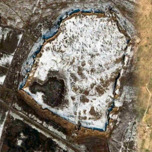
多拉维拉古城是哈拉帕文明的南部中心,位于古吉拉特邦干旱的卡迪尔岛上。该考古遗址在大约公元前3000-1500年间为人类定居点,由一座设防的城市和一片墓地组成,是这一时期保存最完好的东南亚城镇定居点之一。两条季节性溪流为这座带有城墙保护的古城提供了该地区稀缺的水资源。古城包括戒备森严的城堡、仪式场地,以及不同级别的街道和房屋,呈现出等级分 ...
Description N 25 51 to N 26 52 and E 70 18 to E 70 34 The Thar Desert in north-western India is a unique and the only habitat of its type in the Indian subcontinent. The Aravalli hills mark the east
Description Historically, developments in Delhi took place in a triangular patch of land with River Yamuna on one side and the northern range of Aravalli hills on the other two sides. The wider regio
QurgatıshkanqalaQurgatıshkanqalais 20km north-east of To'rtku'l and 4.5km due south of Qoy Qırılganqala. It belongs to thetumanof To'rtku'l. It is directly on the left hand side of the road running north from Eresqala.Q
EresqalaEresqala, sometimes called Arisqala, lies about 15km north east of To'rtku'l on the western edge of the Eresqalaqum Sands in thetumanof To'rtku'l.Eresqala.It is a large enclosure, extending for 360 metres from its north-eastern to south-western si
LocationThe remains of Devkeskenqalaand the old city of Vazir lie 101km west of No'kis and 62km west of Kunya Urgench in the Dashoguzwelayatof northern Turkmenistan. They are situated at the south-western corner of a 30 or 40km-long finger-shaped peninsul
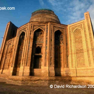
LocationThe Najm al-Din Kubra mausoleum is located in the centre of Kunya Urgench, just south of the Khan-yab canal. It is built in a pretty little walled courtyard with spreading trees located in the centre of a large open area just west of the Dash mosq
库尼亚-乌尔根奇位于土库曼斯坦的西北部、阿姆河的南面,隶属于土库曼斯坦的达绍古兹州,毗邻与乌兹别克斯坦接壤的边境,距离首都阿什哈巴德480公里。古称玉龙杰赤,是古代花剌子模王国的首都,丝绸之路在中亚地区的重要交易都市之一。2005年,作为文化遗产列入《世界遗产名录》。库尼亚-乌尔根奇位于土库曼斯坦的西北部、阿姆河的南面世界遗产委员会描 ...
Description The Cold Desert Cultural Landscape of India is situated in the Himalayas and stretches from Ladakh (in the state of Jammu and Kashmir, or JK) in the north to Kinnaur (in the state of
Justification of Outstanding Universal Value Chilika Lake is the largest brackish water lake with estuarine character that sprawls along the east coast of India. It is considered to be the largest la
Justification of Outstanding Universal Value Chettinad possesses some outstanding physical characteristics of urban and rural planning which create a unique architectural ensemble with thousands of p
Description Cellular Jail is situated on South Andaman Island, one of 572 islands forming Union Territory of Andaman and Nicobar Islands in India. Inhabited since 2000 years, the islands were occupie
Justification of Outstanding Universal Value The Baha’i House of Worship at New Delhi stands in testimony to the efforts of the Baha’is community of Indian subcontinent towards the promotion of commu
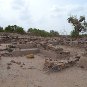
Justification of Outstanding Universal Value The archaeological remains of the Harappan port-town of Lothal is located along the Bhogava river, a tributary of Sabarmati, in the Gulf of Khambat. Measu
Justification of Outstanding Universal Value Related to the Apatani cultural tradition/civilization: The Apatanis, the tribe inhabiting Ziro valley are known for their effective traditional village
Description Sarnath is situated at a distance of 8 km from Varanasi easily accessible by any conveyance. There are several monuments at Sarnath which are divided into two groups. Under Group 'A' Chau
Disclaimer The Tentative Lists of States Parties are published by the World Heritage Centre at its website and/or in working documents in order to ensure transparency, access to information and to fa
Disclaimer The Tentative Lists of States Parties are published by the World Heritage Centre at its website and/or in working documents in order to ensure transparency, access to information and to fa
Description Tansen, the capital of Palpa district, is a typical traditional town of Western Nepal located at an altitude of 1372 meters on the southern slope of the Shreenagar hill. The history of Ta
Disclaimer The Tentative Lists of States Parties are published by the World Heritage Centre at its website and/or in working documents in order to ensure transparency, access to information and to fa
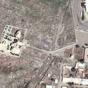
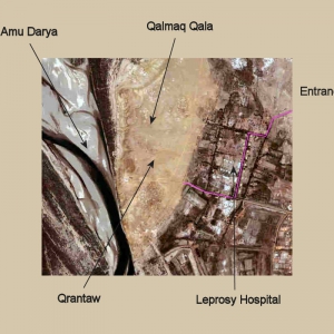
LocationQalmaq or Qalmıqqalais situated on the elevated plateau of Qırantaw, whose western cliffs overlook the right bank of the Amu Darya some 40km downstream from No'kis. It is a quiet and beautiful area, which falls within thetumanof
Description Sinja Valley contains the archaeological evidence of the capital city of the well organized and influential Western Malla or Khasa Kingdom of the 12th and 14th Century. After the 14th Cen
Description The Hindu pilgrimage and crematory centre mentioned in the mythological epics lies on the ancient route to Muktinath and Damodar Kunda. The complex presents various forms of architecture;
Disclaimer The Tentative Lists of States Parties are published by the World Heritage Centre at its website and/or in working documents in order to ensure transparency, access to information and to fa
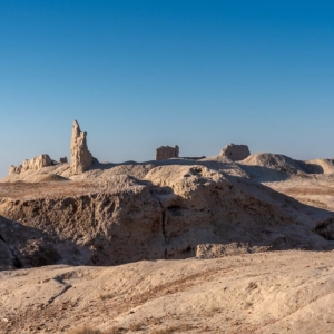
LocationMizdahkan is a huge monument located about 4km west of Xojeli on the main road to the Turkmen border checkpoint and Kunya Urgench.View of Mizdahkan necropolis at sunrise.The site stretches for 2km in one direction and 1km in another, covering thre
Disclaimer The Tentative Lists of States Parties are published by the World Heritage Centre at its website and/or in working documents in order to ensure transparency, access to information and to fa
Disclaimer The Tentative Lists of States Parties are published by the World Heritage Centre at its website and/or in working documents in order to ensure transparency, access to information and to fa
Description Lo Manthang the capital of the former Kingdom of Lo was constructed in the 15th Century on a plateau at 3800 meters above sea level. The settlement is located on the ancient trade route t
Disclaimer The Tentative Lists of States Parties are published by the World Heritage Centre at its website and/or in working documents in order to ensure transparency, access to information and to fa
Disclaimer The Tentative Lists of States Parties are published by the World Heritage Centre at its website and/or in working documents in order to ensure transparency, access to information and to fa
LocationShılpıq is one of the most easily accessible monuments in Karakalpakstan. It is situated on the right bank of the Amu Daryatuman, some 44km south east of No'kis and just 6km downstream from the pontoon bridge at Qipchaq (or Kipch
卡拉卡尔帕克斯坦久卡拉吉亚尔-卡拉,意为“异教徒的堡垒”,是卡拉卡尔帕克斯坦的一处古老聚落,其历史可追溯至公元前4世纪左右。这座堡垒拥有高达十米的坚固城墙,内部包含两座重要城堡的遗址,据信曾分别作为神庙和宫殿使用。该遗址的历史和建筑宏伟,让人得以一窥古代花剌子模丰富的文化画卷。第一座城堡被推测既是防护建筑,也是神庙,反映了当时的精 ...
LocationJanpıqqalais situated on the border line between the flood plain of the Amu Darya and the western foothills of the Sultan Uvays Dag. It is about 2.25km from the right bank of the river and 6km west of the main escarpment of the mountains.
LocationThe Sultan Uvays Bobo mausoleum is located in the barren southern foothills of the mountain chain that bears the name of the Sufi saint - the Sultan Uvays Dag. The mausoleum is surrounded by a massivemazaror cemetery. Higher up the mountain is a h
LocationTeshikqalalies 26.5km north of To’rtku’l. It is not worth a special journey but can be visited on the way from Gu'ldu'rsinqalato Janbasqala.ExcavationsTeshikqalawas studied by Sergey Tolstov and the Tashkent archaeologist Yakh’ya Gulyamov in 1938,
LocationAngkaqalais located on the eastern side of thetumanof To'rtku'l, just under 24km north-east of To'rtku'l town. It is only about 4km east of the desert site of Qoy Qırılg'anqala.ExcavationAngkaqalawas initially investigated by Ser
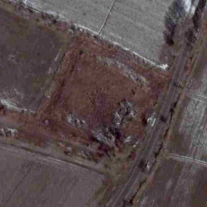
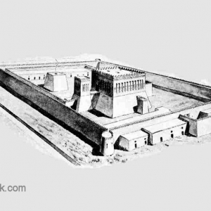
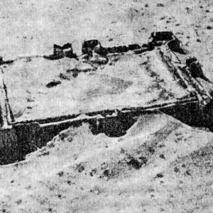
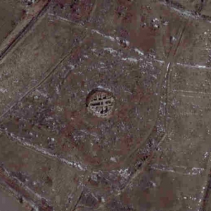
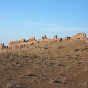
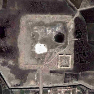
LocationQoy Qırılg'anqalais in a remote desert location, just over 24km north northeast of To'rtku'l and 20km east southeast from Bostan. It lies within thetumanof To'rtku'l.Aerial photograph of the remains of Qoy Qırıl
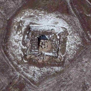
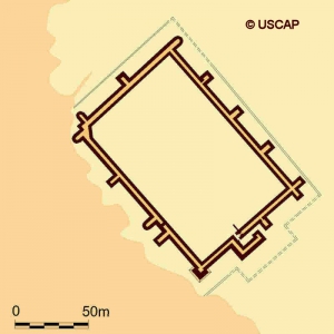
LocationJanbas or Jambasqalain Karakalpak, or Dzhanbas Kala in its Russian transliteration, is about 47km north east of To'rtku'l in the To'rtku'ltumanof Karakalpakstan.View of Janbasqalafrom the road.It is located in a remote region on the last of a chai
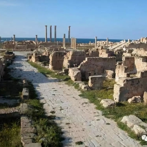
萨布拉塔(Sabrata,或译作塞卜拉泰)考古遗址位于利比亚首都的黎波里以西60公里的地中海岸边,的黎波里至佐乌亚拉的海滨大道从遗址处穿过。萨布拉塔是利比亚境内一处重要的古代罗马城市遗址,公元前5世纪由腓尼基人所建。在罗马帝国时期,萨布拉塔因作为非洲内陆与罗马帝国本土间的转运港口而盛极一时,不过7世纪时遭阿拉伯人摧毁。 萨布拉塔是腓 ...
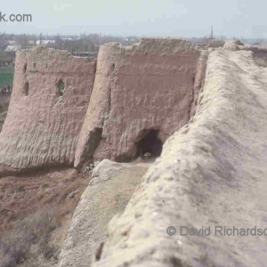
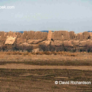
LocationBig Gu'ldu'rsinqala(or Bol'shoi Guldursun Kala in its Russian form) lies just over 15km due north of To'rtku'l in the Ellikqalatumanof Karakalpakstan. The citadel is located within a small rural community and is surrounded by houses and cultivated
LocationA visit to Pil or Filqalais really only for those with a serious interest in the history of Khorezm. It is easily accessible, situated behind a residential street on the northern edge of Biruniy and only 2km north north-west of the city centre. It
IdentityOver the past decade the appellation Kazakl'i-yatkan has become the most commonly used name for this site in both the archaeological literature and the popular media. Kazakl'i-yatkan is an English transliteration of Казаклы-яткан, the simplified R
LocationYakke Parsan has to be reached on foot. It is not easy to get to as it is set back from the road and has a canal running along its western side.To get there drive to Bostan. Head west out of town on the main road that leads to the sports stadium.
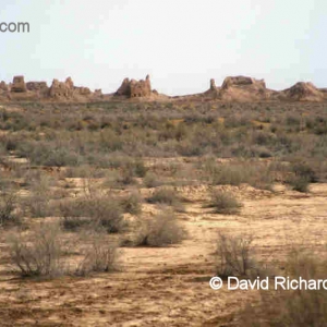
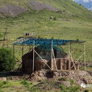
Kyzyl-Kala克孜勒·卡拉克孜勒卡拉要塞位于古代花剌子模(今卡拉卡尔帕克斯坦)的历史区域,紧邻古城托普拉克卡拉。作为托普拉克卡拉防御体系的一部分,克孜勒卡拉起到了至关重要的额外防御作用。作为古花拉子模建筑历史最后阶段的纪念碑,克孜勒卡拉(Kyzyl-Kala)体现了过渡性设计,这些设计后来影响了以巨大波纹柱为特征的阿夫里吉德时期城堡。1938年, ...
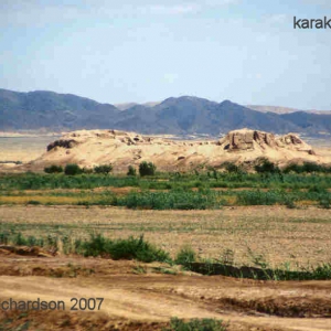
LocationThe site of Topraqqalais 27.5km north of Biruniy and 12km north west of Bostan. It lies just south of the escarpment of the eastern end of the Sultan Uvays Dag.Ayazqalalies 20km to the north east.In fact you can still see Topraqqalafrom the top of
LocationQurgashinqalais known as Kurgashin Kala in Russian. We use the Latin transliteration of the Karakalpak spelling.Qurgashinqalafrom the west.Qurgashinqalalies about 24km due east of Ayazqala. From AyazqalaYurt Camp return on the rough track that run
LocationThe two Qırq Qızqalasare designated Big and Little (or in KarakalpakU'lkenandKishkene). They both lie roughly due east of Ayazqalain the Ellikqalatumanof Karakalpakstan. Little Qırq Qızqalais 6km to the east of
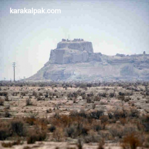
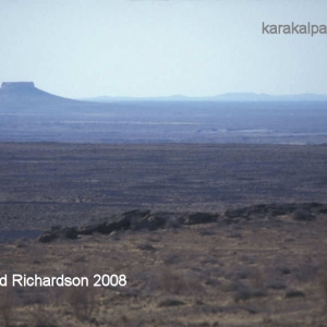
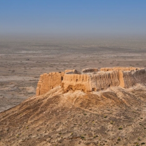
在苏尔泰乌兹达格东部山脊之一那生机勃勃的悬崖上,在广阔的克孜勒库姆沙漠之中,坐落着阿亚兹卡拉的废墟,这是古代花剌子模最大的城堡之一。这座古老的堡垒见证了该地区丰富而传奇的历史,其起源既深植于民间传说,也根植于历史。据当地传说,阿亚兹卡拉(Ayaz-Kala)得名于阿亚兹(Ayaz),他是中亚突厥民间传说中一位传奇的奴隶战士。据说这位半神话中 ...
包括唐火寻时代城墙
The ruins of the city of Zamakshar are today frequently referred to as Izmukshir, the name of the small settlement that lies just to the east of the site. In the 19th century it was called Zmukshir or Zmukhshir.The site is located in the Dashoguzwelayatof
古粟特之卡尔希至呼罗瑚谋夫地区途中古渡
丹加拉 塔吉克斯坦和德国的考古学家组成的联合考古小组,目前正在研究库尔索夫山脊脚下的古代定居点,该遗址距丹加拉地区区域中心25公里。 历史学,考古学和人类学研究所下属的考古部的员工以及德国考古研究所(柏林)的欧亚分部,于2017年在丹加拉地区发现了一个希腊化神庙遗址。 这个遗址的历史可以追溯到公元前3世纪。考古部门的主要研究员塔 ...
穆尔加布 高耸的穆尔加布地区,充满着浓厚的神秘色彩。2018年7月,新西伯利亚国立大学,塔吉克斯坦科学院历史,考古和人类学研究所考古部展开了合作。今年,来自新西伯利亚的考古学家再次来到穆尔加布地区展开了考古发掘工作。 帕米尔探险队负责人斯维特拉娜·施耐德说:“我们可以自信地说,一个(群)人在几千年前就住在帕米尔高原,但我们不知道是 ...
拉格曼遗址 自今年起,鲁里丁·赛义夫诺耶夫开始负责在巴尔赫地区的古代堡垒拉格曼进行挖掘。一组考古学家发现了萨曼王朝时期的墙壁和建筑墙体部分,以及几件陶器。 古老的拉格曼,位于瓦赫什河岸上。根据历史学家的说法,这一领域的最早研究可以追溯到1875年。该镇距离另一个古老的遗址-哈莱沃德定居点有12公里。 拉格曼城堡遗址占地约42.5公顷 ...
法尔霍尔 在法尔霍尔地区中心的郊区,一支由塔吉克斯坦,俄罗斯和意大利的科学家组成的国际探险队发掘了一个青铜器时代的墓地。 根据考古发现,他们得出的结论是,该地区人类发展的最初痕迹记录在公元前6-5世纪的两个新石器时代遗址上,它们位于红河沿岸阶地。在同一地点,发现了一个土墩和一个定居点,其名称为马涳尼 莫隆遗址(公元前二千年晚期- ...
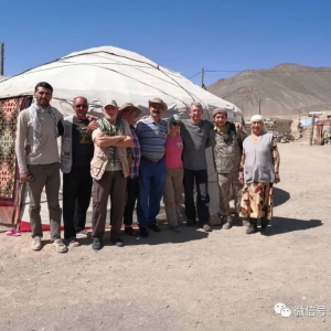
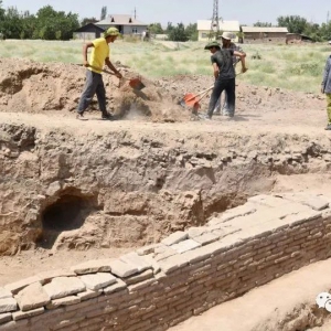
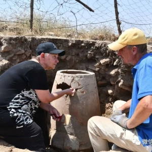
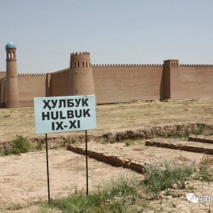
胡勒布克遗址 塔季扬娜·菲利莫诺娃,谈到了位于哈特隆地区沃瑟地区的胡勒布克城堡的发掘。据她说,将该遗址提名为中世纪哈特隆之都项目的准备工作即将完成。 “我们与文化部古迹保护部门,以及胡勒布克历史文化保护区合作,准备出版一本专门针对胡勒布克的书,名为《中世纪胡勒布克的手工艺品》。 这本书描述了从古代巴克特里亚时代(公元前两千 ...
卡隆遗址 卡隆遗址,是塔吉克斯坦考古学家,科学院院士,雅库波夫教授于2012年首次发现。据雅库波夫教授称,这座城市始建于四千年前。自2012年以来,历史学,考古学和人类学研究所组织人员对该处遗址进行了发掘;来自俄罗斯,伊朗,法国和比利时的考古学家也参加了发掘。 在挖掘过程中,发现了马场,天文台,风车和琐罗亚斯德教圣所的遗物 - 一个 ...
明特佩遗址(Mingtepa)。位于安集延省马哈马特东郊。城近长方形,略微有些斜,我们由西墙缺口进入,城墙保存很好,但城内已经是农田和果园。 1939年在建设费尔干纳大引水渠的时候,M.E.Masson带领考古学家参观了这个遗址,1946-1947年、1950年A.N,Bernshtam带领的帕米尔-阿尔泰考古队调查了遗址。1973、1986-1987年札德涅普罗夫斯基发掘了遗址。2001年马 ...
埃拉坦(Eylatan)遗址。位于安集延东北不远的哈库拉巴德(Hakkulabad)东部埃拉坦村附近,遗址近长方形,时代为公元前6-前4世纪,原来也是有二重城墙。保存非常不好,二十世纪三十年代,B.A.Latynin率领的考古队调查时,内外城墙都还存在,现在内城城墙只剩东西两段,沿遗址中的现代水沟行走,几乎不能发现陶片。遗址总共200公顷,内城墙以内20公顷。1934 ...
达尔维津遗址(Dalverzin)是中亚青铜时代晚期至早期铁器时代最大的一个的遗址,位于塔什干州白克阿瓦德区境内位于达尔维津村附近。处于一个椭圆形高地上,面积有25公顷,主要是楚斯特文化的堆积,最厚的堆积达4米,时代为公元前12世纪至公元前7世纪。自1952年开始,札德涅普罗夫斯基(J.A.Zadneprovskiy)开展了16个季度的考古工作,主要集中在祭祀遗址的 ...
楚斯特遗址(Chust)位于费尔干纳盆地西北部的楚斯特镇北部尕瓦河的低地附近高地上。面积有5公顷,文化堆积厚3米。1950年M.E.Vorontsov和V.I.Sprishevshiy发现该遗址,1953-1963年,经过9个季度的发掘,V.I.Sprishevshiy发掘了遗址的主要部分,约7000平米。1974年,J.A.Zadneprovskiy发掘了一部分。1982年-1983年马教授也主持了发掘。 楚斯特遗址有西北部 ...
Description The city of Herat, which is currently the regional capital of western Afghanistan, has long been of strategic, commercial and cultural significance to the wider region. Although the city
Disclaimer The Tentative Lists of States Parties are published by the World Heritage Centre at its website and/or in working documents in order to ensure transparency, access to information and to fa
Description The city of Balkh comprises a large urban site of some 11 square kilometres, lying west of the modern regional capital of northern Afghanistan, Mazar i Sharif, and about 46 miles south of
Statements of authenticity and/or integrity As outlined above, Bagh-e Babur reflects four main periods of use over 500 years: the late Timurid tradition, the Mughal tradtion, with at least three buil
乌兹别克古代粟特城址。在撒马尔罕城北。城平面为三角形,面积219公顷。北部建于公元前6世纪 。公元前4世纪被希腊马其顿王亚历山大军队占领;古希腊人称此地为马拉坎达。至撒马尔罕城北,居住区已扩大至整个古城 ,成为粟特地区最大的政治经济中心。出土的这一时期的雕塑少数与希腊罗马神话有关,有的与祆教崇拜有关。还有国王会见外国使节的彩色壁画。阿 ...