遗产数据库
多拉维拉:哈拉帕文明古城Dholavira: A Harappan City
多拉维拉:哈拉帕文明古城
Dholavira: A Harappan City
申报国:印度
价值标准:(iii), (iv)
多拉维拉古城是哈拉帕文明的南部中心,位于古吉拉特邦干旱的卡迪尔岛上。该考古遗址在大约公元前3000-1500年间为人类定居点,由一座设防的城市和一片墓地组成,是这一时期保存最完好的东南亚城镇定居点之一。两条季节性溪流为这座带有城墙保护的古城提供了该地区稀缺的水资源。古城包括戒备森严的城堡、仪式场地,以及不同级别的街道和房屋,呈现出等级分明的社会秩序。复杂的用水管理系统展示了多拉维拉人在恶劣环境中生存和发展的聪明才智。该遗址还包括一个大型墓地,6种类型的墓碑诠释了哈拉帕文明对死亡的独特见解。考古工作者发掘出珠子加工作坊及由铜、贝壳、石头、半宝石首饰、陶土、黄金、象牙等材料制成的各种文物,展示了该文明的艺术和技艺成就。他们还发现了此地与其他哈拉帕文明城市以及美索不达米亚地区、阿曼半岛的城市进行区域间贸易的证据。
Justification of Outstanding Universal Value
The City of Dholavira located in Khadir island of the Rann of Kutchch belonged to matured Harappan phase. Today what is seen as a fortified quadrangular city set in harsh arid land, was once a thriving metropolis for 1200 years (3000 BCE-1800 BCE) and had an access to the sea prior to decrease in sea level.
The excavated site of Dholavira demonstrates the ingenuity of Harappan people to evolve a highly organised system of town planning with perfected proportions, interrelation of functional areas, street-pattern and an efficient water conservation system that supported life for more than 1200 years (3000 BCE to 1800 BCE) against harsh hot arid climate. Its scale of enclosures, the hierarchical street pattern and defined spatial utilization i.e. land for industries, administration etc, as well as infrastructure like waste water disposal system, show the sophisticated urban life enjoyed between in this metropolis. With its acropolis or citadel within the fortified area Dholavira remains the most expansive example of the Harappan town-planning system where a three-tier zonation comprising of a distinct upper (citadel, bailey) and middle (having a distinct street-pattern, large scale enclosure and a ceremonial ground) towns enclosed by a lower town (with narrower streets, smaller enclosures and industrial area (suggested by articles recovered)) – distinguishes the city of Dholavira from other metropolises of the Indus Valley Civilisation.
The importance of Dholavira`s planning was furthered with the excavation of Kampilya (the capital of South Panchala of Mahabharata), Uttar Pradesh, a city considered of mythical origin in the Gangetic plains. Belonging to the Gangetic Civilization, which is considered the second phase of urbanization of the Indian, sub-continent, Kampilya adopted the town planning principles (in terms of scale, hierarchy of space and road network) established in Dholavira. Kampilya, transformed under continued habitation, the importance of Dholavira remains lie in its ability to illustrate planning and urban life in two distinct subsequent cultural phases of the Indian Subcontinent.
The expansive water management system designed to store every drop of water available shows the ingenuity of the people to survive against the rapid geo-climatic transformations. Water diverted from seasonal streams, scanty precipitation and available ground was sourced, stored, in large stone-cut reservoirs which are extant along the eastern and southern fortification. To further access water, few rock-cut wells, which date as one of the oldest examples, are evident in different parts of the city, the most impressive one being located in the citadel. Such elaborate water conservation methods of Dholavira is unique and measures as one of the most efficient systems of the ancient world.
The property after excavation has been stabilized ensuring protection of its physical integrity. The site excavated over a period of time has been retained as partly exposed to avert deterioration due to weathering.
The excavated remains retain the hierarchy and inter-relationship of spaces, street patterns, large cavities that were once the water-reservoirs and altogether illustrate the sophisticated life in metropolis of Dholavira. The archaeological remains of the city, together with the dried of rain-fed channels and moveable articles demonstrate life and geo-climatic condition between 3000 BCE-1800 BCE in Khadir Island.
The property comprising of the excavated remains and the Buffer including the dried channels are protected and managed by the Archaeological Survey of India where mandates are governed by the Ancient Monuments and Sites Remains Act’1958 (amended in 2010). The site is set in a barren landscape, devoid of habitation where negligible exogenous factors exist that could impact the property.
Criterion (v): The excavated site of Dholavira demonstrates the ingenuity of Harappan people to evolve a highly organised system of town planning with perfected proportions, interrelation of functional areas, street-pattern and an efficient water conservation system that supported life for more than 1200 years (3000 BCE to 1800 BCE) against harsh hot arid climate. Its scale of enclosures, the hierarchical street pattern and defined spatial utilization i.e. land for industries, administration etc, as well as infrastructure like waste water disposal system, show the sophisticated urban life enjoyed between in this metropolis. With its acropolis or citadel within the fortified area Dholavira remains the most expansive example of the Harappan town-planning system where a three-tier zonation comprising of a distinct upper (citadel, bailey) and middle (having a distinct street-pattern, large scale enclosure and a ceremonial ground) towns enclosed by a lower town (with narrower streets, smaller enclosures and industrial area (suggested by articles recovered)) – distinguishes the city of Dholavira from other metropolises of the Indus Valley Civilisation.
The importance of Dholavira`s planning was furthered with the excavation of Kampilya (the capital of South Panchala of Mahabharata), Uttar Pradesh, a city considered of mythical origin in the Gangetic plains. Belonging to the Gangetic Civilization, which is considered the second phase of urbanization of the Indian, sub-continent, Kampilya adopted the town planning principles (in terms of scale, hierarchy of space and road network) established in Dholavira. Kampilya, transformed under continued habitation, the importance of Dholavira remains lie in its ability to illustrate planning and urban life in two distinct subsequent cultural phases of the Indian Subcontinent.
The expansive water management system designed to store every drop of water available shows the ingenuity of the people to survive against the rapid geo-climatic transformations. Water diverted from seasonal streams, scanty precipitation and available ground was sourced, stored, in large stone-cut reservoirs which are extant along the eastern and southern fortification. To further access water, few rock-cut wells, which date as one of the oldest examples, are evident in different parts of the city, the most impressive one being located in the citadel. Such elaborate water conservation methods of Dholavira is unique and measures as one of the most efficient systems of the ancient world.
注册时间:2021年
标准:(iii)、(iv)
类型:文化遗产
描述:多拉维拉:哈拉帕文明古城是哈拉帕文明的南部中心,位于古吉拉特邦干旱的卡迪尔岛上。该考古遗址在大约公元前3000-1500年间为人类定居点,由一座设防的城市和一片墓地组成,是这一时期保存最完好的东南亚城镇定居点之一。
概况介绍
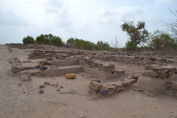
印度古吉拉特邦,西边与巴基斯坦国境接壤、南边面朝阿拉伯海。该邦的西北部被广袤平坦的卡奇沼泽地所占据。这片沼泽地含盐量较高,每到8~9月的季风季节时就会因水涝使得沼泽地水量充沛,而到了旱季由于水分蒸发则会变成陆地,且陆地表面被盐的结晶所覆盖,看上去如同一片白茫茫的雪原,十分美丽。这片沼泽地中有一座名为卡第路的小岛,岛上有着解开印度河流域文明之谜的关键钥匙——多拉维拉遗迹。这座遗迹是最近几年才引起世人关注的。遗迹的发现时间在1967年,直到1989年才开始正式的发掘调查工作。而早在上世纪20年代,在巴基斯坦地区的印度河流域被相继发现的摩亨约·达罗、哈拉帕等遗迹,充分证明了公元前2500~前2000年期间,印度河流域文明的鼎盛时期是真实存在的。多拉维拉遗迹的发掘工作由印度考古局负责,属于国家性质的工作,多年来一直禁止国外媒体进行采访报道,直到2000年才解禁。被发现的多拉维拉城整体由外墙包围着,东西长781米、南北长630米。城市被划分为几个区域,南部区域的宏伟要塞可能是统治者的居住地。要塞东西走向达151米、南北走向118米,由厚度约10米的墙包围着。遗迹所属时代据说可以追溯到公元前2000年以前,整个遗迹的规模堪比摩亨约·达罗遗迹和哈拉帕遗迹,基本可以断定是印度河流域文明的古代城市遗迹。
从多拉维拉遗迹中发现的水渠、道路等结构遗迹说明,这座城市与印度河流域文明其他城市遗迹一样,都是规划性、计划性很强的城市,而且,这里还有一些独特之处。与摩亨约·达罗遗迹不同,多拉维拉遗迹最主要的要塞部分并不是砖造的,而是用切成方形的石块堆积建造而成的。要塞中还建有几座大门,北门面对着广场,可以眺望城市大半部分,据推测可能是城市的正门。从北门内侧的石阶一下来就能发现“印度河流域文字”,似乎可以从侧面印证这一点。这些文字不是雕刻在石头或者木材之上,而是用类似石膏的物质做成的。发现的文字共计9到10个,每一个字都高30厘米,宽27厘米,尺寸都很大。遗憾的是,这些文字的意思还没有被解读出来。目前已发现的文字都是被刻在印章上的,从内容篇幅来说极其短小,也没有发现像埃及罗塞塔石碑那样的,用不同的古代语言分别记载的文物,可以用于解读文字意义的线索少之又少。不过有人猜测这些文字记载的可能是城市的名字、王室、崇拜之神的名字。在要塞的南侧有着城市建筑,那就是直径4.1米的石造井,堪称印度河流域文明最大的井。井的上方有绳索留下的痕迹,昭示着这里曾经是取水地。其实“多拉维拉”就有“白色水井”的意思。更有意思的是,水井的上端还设有孔洞,从井中打上来的水通过这些孔洞,流向下方建造的水道。流向这两个储水槽的水,并不单单作为生活用水在使用。据推测,蓄水槽主要是向沐浴场供水。这里说的沐浴并非出于卫生上的需要,而是用于洗去沾染在身心上的罪孽,是宗教形式上的沐浴。现代印度人也保留着这种习俗,类似于日本的一种神道仪式——袯濯。这样看来,这座要塞很可能就是一座神圣场。其实在要塞的外部也发现了蓄水槽。位于要塞东面的蓄水槽,南北长70米,东西长24米,深达7.5米,是基于巨大的岩石层建造的,从规模上来说,称之为蓄水池更为贴切。在要塞的南面也有大大小小数个泳池般的蓄水池呈东西方向排列着。据说在要塞的西面也有蓄水池。也就是说距今4500年前的多拉维拉城,仿佛是漂浮在满溢着水的人造池之中。
遗产价值
哈拉帕文明古城由一座设防的城市和一片墓地组成,是这一时期保存最完好的东南亚城镇定居点之一。
遗产保护
多拉维拉的考古遗址受到印度考古调查的保护和管理。该财产受到国家一级法律的保护,即1958年“古代纪念碑和考古遗址及遗骸法”(AMASR),该法于2010年修订;1959年“古纪念碑和考古遗址及遗骸规则”;2011年“古纪念碑和考古遗址及遗骸规则”;1972年“古物和艺术珍藏法”和1973年规则。多拉维拉古遗址被指定为具有国家重要意义的“古代纪念碑”,受禁区保护,从保护纪念碑的界限向各个方向延伸100米,而在保护区范围以外,则有200米的受管制区域,不受禁区的限制。在多拉维拉古遗址附近地区的所有活动仍须按照“2011年古物和考古遗址和遗骸规则”的规定,在受禁和受管制地区受到禁止和管制。缓冲区覆盖卡迪尔岛的整个西带,这确保了对更广泛的财产设置的保护。印度政府正在将缓冲区内的古老采石场列为具有国家重要性的采石场。
数据来源:世界遗产中心官网、浏览器搜索等。
多拉维拉:哈拉帕文明古城