遗产数据库
土库曼斯坦库尼亚乌尔根奇The City of Urgench
库尼亚-乌尔根奇位于土库曼斯坦的西北部、阿姆河的南面,隶属于土库曼斯坦的达绍古兹州,毗邻与乌兹别克斯坦接壤的边境,距离首都阿什哈巴德480公里。古称玉龙杰赤,是古代花剌子模王国的首都,丝绸之路在中亚地区的重要交易都市之一。2005年,作为文化遗产列入《世界遗产名录》。

世界遗产委员会描述:库尼亚-乌尔根奇位于土库曼斯坦的西北部、阿母河的南面。乌尔根奇是阿契美尼德帝国统治下可兰次姆地区的首都。古镇拥有一系列11-16世纪时期的纪念碑,包括一座清真寺、旅馆的门、堡垒、陵墓和一座尖塔。这些纪念碑展示了当时建筑和手工艺方面的卓越成就,其影响力波及伊朗、阿富汗和16世纪印度的后期建筑。
中亚地区最古老的城市之一
库尼亚-乌尔根奇又称老乌尔根奇,区别于乌兹别克斯坦境内的乌尔根奇。库尼亚-乌尔根奇是阿契美尼德帝国统治下可兰次姆地区的首都,是中亚地区最古老的城市之一,古镇拥有一系列11-16世纪时期的纪念碑,包括一座清真寺、旅馆的门、堡垒、陵墓和一座尖塔。这些纪念碑展示了当时建筑和手工艺方面的卓越成就,其影响力波及伊朗、阿富汗和16世纪印度的后期建筑。”库尼亚-乌尔根奇为伊斯兰文化的独特保存状态提供了一个特殊的例证,尽管它已经不复为一个国家的中心,但仍有许多旅客前往那里朝圣。

库尼亚-乌尔根奇古称玉龙杰赤,又称玉里健、乌尔达赤、兀笼格赤、花剌子模城、乌尔坚奇等,在西元10世纪时,成为花剌子模地区最大的城市,也是丝路在中亚地区的重要交易都市之一。12世纪时,花剌子模王国兴起,玉龙杰赤成为该国的首都,但是到了阿拉乌丁·摩诃末苏丹时期,因为政治上的因素,而将帝国首都由乌尔根奇迁到撒马尔罕。1220,玉龙杰赤遭成吉思汗率领的蒙古军队的进攻,进行顽强抵抗后最终于1221年沦陷,惨遭屠城。
16世纪以后,该城逐渐重建,但由于阿姆河改道,政治、商业的重心渐渐移向了南部的希瓦。1646年,老乌尔根奇(玉龙杰赤)被毁弃。1929年,人们组织了对老乌尔根奇遗址的第一次考古行动。2005年,联合国将库尼亚-乌尔根奇列入世界文化遗产名录,成为土库曼斯坦境内的重要旅游景点之一。
繁华落尽的兵家争斗之地
库尼亚-乌尔根奇的早期历史可以追溯至公元前6-前5世纪,古波斯的阿契美尼德王朝早期。公元712年,遭到阿拉伯人入侵,并改名为玉龙杰赤。由于地处丝绸之路,玉龙杰赤逐步繁荣起来,成为中亚地区的重要中心城市。

公元995年,马蒙·伊本·穆罕默推翻了花剌子模的实际统治者阿夫格里王国,建立了王国(995-1017年),以花剌子模沙的称号统治着该地区,并将玉龙杰赤设为王国首都。11-12世纪时,花剌子模王国兴起,玉龙杰赤作为中亚地区最繁荣国家之一的首都,成为东方最美丽、设备最完善的城市之一,同时也是文化中心。在花剌子模朝廷里住着许多东方国家的杰出学者。直到阿拉乌丁·摩诃末时期,因为政治上的因素,帝国首都被迁至撒麻耳干(今乌兹别克斯坦的撒马尔罕)。
1220年秋至次年春,蒙古军队连破花剌子模城池,在河中之战中,成吉思汗命术赤为主帅,察合台、窝阔台为副帅,率军合围玉龙杰赤,又分兵封锁呼罗珊北境,截断其后路。由于术赤和察合台意见相左,蒙古军围城六个月而不下,成吉思汗在塔里寒闻报,改命窝阔台统全军,限其克日攻下玉龙杰赤。
公元1221年4月,玉龙杰赤城破,残军及妇孺誓死抵抗,巷战七昼夜,蒙古军驱赶出城,挑选出10万工匠送往东方。5万壮丁编签军,妇孺尽为奴婢。其余居民被悉数屠杀。蒙古军队又掘开阿姆河,引水淹城,将玉龙杰赤夷为平地。
成吉思汗死后,蒙古帝国四分五裂,花剌子模地区被金帐汗国所统治。玉龙杰赤在原城池的南方重建,到了14世纪重新成为花剌子模地区的最大都市。但是1372年-1388年间,玉龙杰赤再一次被中亚地区的新统治者帖木儿帝国所征服。出于对于花剌子模的忌惮,帖木儿于1388年强令居民迁出玉龙杰赤并摧毁了该城,此后该地区的繁华便日渐没落。

两千多年的古老建筑
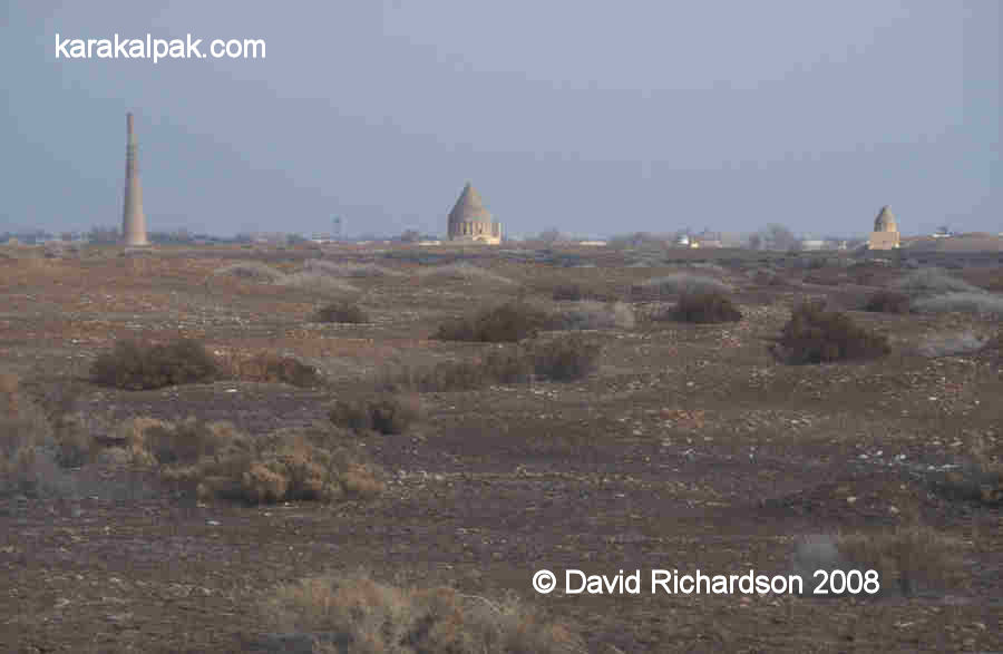
库尼亚-乌尔根奇遗迹,现已经开辟为博物馆,主要建筑包括丝绸之路驿站、清真寺塔和诸多名人墓等,其中最古老的建筑已经有两千年的历史。如今游客所能看到的古都约有超过350公顷(3.5平方公里),散布着一系列包括由泥砖建筑而成的曾用于防卫的碉堡等遗迹。这里得以保存的遗迹主要是以烧砖修筑而成的陵寝,用釉面砖、切割砖和灰泥装饰装修的清真寺。由于这个小城缺乏旅游服务设施,因此大部分游客在达绍古兹过夜。
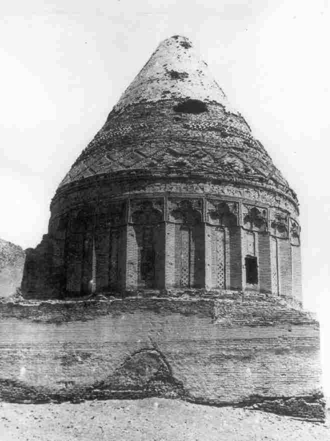
库特卢-帖木儿清真寺:是一个伊斯兰式的宣礼塔,高约60米,由砖砌成,有亮蓝色的飞檐,是中亚地区最高的宣礼塔之一。塔内有梯子盘旋而上,梯子共有144个台阶,但不允许游客攀登。陵墓的门饰花纹雕刻技术十分精湛。该建筑被考古学家认为是一座陵墓,但也有一些考古学家认为它是建于12世纪的一座神庙。但无论如何,该建筑均可视为中亚地区的最完美的建筑之一。穹顶内365个细瓷部分代表一年365天,穹顶垂直下方的24个弧形代表一天24小时,下面12个较大的弧形代表一年12个月,4扇大窗户代表一个月4个星期。
帖乞失陵墓与阿尔斯兰陵墓:帖乞失(又称塔乞失,塔喀什等)为阿拉乌丁·摩诃末的父亲,1172年至1200年在位,曾与兄弟苏丹·沙赫争立,后在西辽帮助下即位。阿尔斯兰,为帖乞失的父亲,阿拉乌丁·摩诃末的祖父,1156年至1172年在位。蒙古军攻陷玉龙杰赤后,这两座坟墓得以幸存并成为如今库尼亚-乌尔根奇的标志建筑。
库白拉墓:是12世纪著名的伊斯兰教师与诗人的陵墓,这座陵墓是小镇中最神圣的地方。据说陵寝有治愈疾病的力量,所以有很多信徒在此祈祷。
Location
The site of the ruined city of Kunya or Old Urgench lies about 2.5km south of the centre of the modern town of Kunya Urgench in the Dashoguz welayat of northern Turkmenistan. The site is about 43km west southwest of No'kis. Foreign tourists can cross the Karakalpak-Turkmen border checkpoint between Xojeli and Kunya Urgench, but must be in possession of a visa for Turkmenistan . See the "How to Get There" page of our Tour Guide.
|
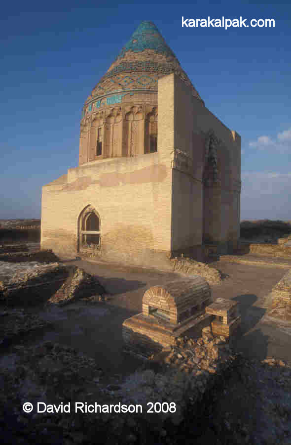
Image courtesy of the Ministry of Culture, Ashgabat.
From the Central Bazaar in Kunya Urgench drive west for 400 metres and turn left, crossing the Khan-yab canal. Just over 2km from the canal the road reaches the northern boundary of the Archaeological Park. There is a car park on the left next to the Tura beg Khanum Mausoleum. There are official opening hours and an admission charge. This used to be 11,000 manat for foreigners and 1,000 manat for locals, but may now have increased.
Excavations
Despite being one of the most important medieval sites in Khorezm - its capital for over half a millennium - Kunya Urgench has been very much neglected by the archaeological fraternity. The reasons for this are not entirely clear - it was not because the site was located in the Turkmen rather than the Uzbek SSR. The Khorezm Archaeological-Ethnographical Expedition conducted a large amount of work in northern Turkmenistan from the 1950s through to the 1980s. Maybe Tolstov was not excited by such an obvious and easily accessible site.
|
Qutlugh Timur Minaret left; Sultan Tekesh Mausoleum centre; and Fakhr ad-Din Razi Mausoleum right.
The failure to conduct rigorous and persistent research on the site means that there remains considerable uncertainty surrounding the dating and function of many of the monumental buildings that occupy the archaeological park.
The first scientific study of Kunya Urgench was undertaken in 1928 and 1929 by an expedition from the State Academy for the History of Material Culture led by A. Yu. Yakubovsky. In 1938 the architect V. I. Pilyavsky surveyed the site and measured and described its monuments. Photographs appeared in a 1939 publication on the monuments of Turkmenia.
|
After the war, Sergey Tolstov's Khorezm Archaeological-Ethnographical Expedition began the first archaeological studies on the site. In 1952 they examined three objects in the medieval citadel known as Tash Qala – the southern gate and wall, part of the urban district and the remains of a minaret. Amazingly their work was not continued in other parts of the ruined city. No further archaeological research took place until 1979.
The architectural details of the monuments and the methods used to construct them had already been studied by N. S. Grazdankina during the 1950s. Between 1958 and 1960 Aleksandr Vinogradov, A. Asanov and I. I. Notkin drew up plans of the monuments and recorded their physical status as a basis for making recommendations about their restoration. In the 1960s and 1970s the monuments at Kunya Urgench continued to attract the general attention of a variety of Central Asian scholars, including Mikhail Evgeniyevich Masson and his wife Galina Anatolyevna Pugachenkova.
Archaeological work partly resumed between 1979 and 1985, with the Uzbek Institute of Conservation excavating the so-called "caravanserai portal" in the south of the site.
More extensive work was conducted between 1988 and 1993 by the Kunya Urgench Archaeological Expedition of the Institute of History of the Academy of Sciences of Turkmenistan, led by Kh. Yusupov. This included excavating the western part of the earliest settlement on the site, Kyrk Molla, in 1991. This exposed the foundation of a defensive wall with towers.
A Short History of Gurganj/Urgench
To properly understand the archaeological site it is helpful to have an overview of its traumatic history. In short the city developed from the north to the south over a period of more than two thousand years.The earliest settlement, known as Kyrk Molla, is located in the north-eastern corner of the complex. On the basis of finds of ceramics, it seems to date from the 4th century BC, a time when Khorezm had just gained its independence from the Persian Achaemenid Empire. It was one of many settlements on the western bank of the Amu Darya at that time, along with Hazarasp and the Ichan qala at Khiva. Some have suggested that it might have been called Urva, one of the regions listed in the Zoroastrian Avesta. However many scholars associate Urva with Kabul in Afghanistan. It seems to have been occupied well into the 6th and 7th centuries AD, the Afrigid feudal period.
It was not until the 7th century AD that a new fortified town sprung up just south of the ruins of Kyrk Molla. According to the early Arab historians, in 712, the date of the Arab invasion, the town was in a breakaway region ruled by an independent "King of Khamjird" who may have been the brother of the Khorezmshah. It is not clear whether Khamjird was the name of the new town – as some have suggested - or of some neighbouring city or indeed of the region as a whole. While the Arab general Qutayba was preparing to invade Samarkand, the Khorezmshah made a secret pact with him as a result of which Khorezm became a tributary state in return for Qutayba's military intervention in deposing the rebellious King of Khamjird.
|

The Arabs named the new town Jurjaniya, although the local people came to call it Gurganj. It became an administrative capital for the Arab deputies, who were responsible for taxation and the promotion of the Muslim faith. As the most northerly town in Khorezm it soon became a major trading centre for the surrounding nomadic tribes and a thriving economic and cultural centre, greatly helped by the revitalising of the local agricultural region thanks to a change in the flow of the Amu Darya. Gurganj was surrounded by a defensive wall and probably had a central square surrounded by houses and winding streets, along with the rulers palace (the Kyrk Molla?).
The anonymous Hudûd al-Âlam, written around 982, noted that although Gurganj had previously belonged to the Khorezmshah, it was now governed independently. It briefly added that:
"The town abounds in wealth, and is the Gate of Turkistan and resort of merchants. The town consists of two towns: the inner one and the outer one. Its people are known for their fighting qualities and archery."The chronicler al-Muqaddasi also described the town in the 10th century when it was the seat of the Amir Ma'mun. It had four gates and the waters of the canals came only as far as those gates since there was insufficient room for the canals to continue into the city. The palace of Ma'mun was located close to the Hajjaj gate. Apparently the gates of the palace itself were of particularly beautiful workmanship, having no equal in the whole of Khurasan. Somewhat later, Ma'mun’s son Ali, who succeeded him in 997, built another palace in front of his father's. He also laid out a square in front of the palace gates in imitation of the Registan in Bukhara, and this was later used as a livestock market. In 1010, another of Ma'mun’s sons, Ma'mun ibn Ma'mun, built a minaret. One of the major city sights was to be seen about ¼km from the centre of Gurganj, where the course of the Amu Darya was deflected to the east by a huge wooden dam. Prior to the construction of this dam the water came up to the walls of the town.
In 995 the army of the Amir Ma'mun deposed the Khorezmshah and the capital of Khorezm transferred from Kath to Gurganj. However his dynasty was short- lived. In 1017 his son Ma'mun II was overthrown by the Ghaznavids (from Afghanistan) who placed their own representative on the Khorezmian throne. Twenty- six years later the Ghaznavids were in turn ousted by the Seljuk Turks of Iran and Khorezm became a province of Khurasan. Seljuk authority over Khorezm rested with Anush-tegin, a former slave who had risen through the ranks to become a senior military general. In 1097 Anush-tegin's son, Qutb ad-Din Muhammad, was appointed Khorezmshah, the first of one of the most successful line of rulers in Khorezm's history – the Anushteginid dynasty of Khorezmshahs.
It was an unstable time when the Aral region was facing an influx of warlike Turkic nomads known as Qipchaqs. The Khorezmian rulers progressively formed alliances with the Qipchaqs and recruited them as a mercenary army. Indeed the economy of Gurganj was partly dependant on trade with the nomads.
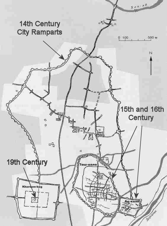
By the 12th century Gurganj was by far the largest city in Khorezm. Aerial photography suggests that the city had expanded to the west of the old Arabic citadel, on both the north and the south sides of a small river channel, a branch of the Darya Lyk. In the south-west of the city the "new town" district of Kaan, only developed during the previous century, had many parallel streets oriented in an east-west direction. However because the city's defensive walls had been built along the banks of natural rivers the city had quite an irregular shape.
It is possible to assemble a cameo of the city from the scraps of information provided by writers such as Nesevi, writing just before the succession of the Khorezmshah Tekesh, and Juvaini writing after the Mongol conquest. The city was walled and defended by gates, one of which was called the Aqabilan Gate and a second the "gate of peace". The city was divided up into residential blocks and contained a magnificent Shafi'ite cathedral mosque, a mosque library, five teaching medressehs, and the "old" Kushk-i Akhchak palace. Juzjani mentions the bridge across the river and "the garden of amusements" just outside of the city. Later information of unknown origin suggests it also contained a bazaar, baths, a minaret, the tomb of the Khorezmshah Muhammad's daughter and several more mausoleums. The Syrian geographer Yaqut, who lived in the city from 1219 to early 1220, considered Urgench to be the most extensive and the richest of all the towns he had seen.
It all came to an end in 1221. The Khorezmshah Ala ad-Din Muhammad began exchanging embassies with a Mongol ruler in the east named Chinggis Khan. In 1218 a Mongol caravan was attacked by the authorities of Otrar, an oasis on the north-eastern frontier of Khorezm. Perhaps the caravan had been a cover for Mongol spies. Whatever the reason, its merchants were massacred and its merchandise seized. Chinggis Khan demanded that the Khorezmshah extradite his governor for punishment in Mongolia. Muhammad's refusal precipitated one of the greatest events in world history - the Mongol invasion of western Eurasia. At the start of 1221 a large Mongol army surrounded the walls of Gurganj, supported by Chinese military engineers. Within months the walls had been breached and the defenders massacred or enslaved.
While the city may have been badly damaged, the Mongols had no desire to destroy it. They renamed it Urgandj or Urgench and it became part of the Khanate of Qipchaq (later to be known as the Golden Horde) along with the rest of left bank Khorezm, ruled from the nomadic capital of the Mongols on the Volga. Urgench rapidly recovered to become a thriving commercial centre, a staging post on the important trading route between Europe and the Black Sea ports in the west and Mongolia and China in the east. Many Italian merchants established trading operations in the city, which was also the location of one of the Golden Horde's three mints. Urgench also became an important religious Sufi centre and a seat of Islamic learning, culture and literature. The city rapidly expanded in all directions, its ramparts stretching 3km from north to south and by 2km from east to west.
|
Ibn Battuta provided us with an excellent eyewitness account of the bustling city when he passed through it on his journey to Bukhara in the 1330s. He had just spent 30 days crossing the Ustyurt desert after leaving Sultan Uzbek's brand new capital of Saray al-Jadid. He was clearly impressed:
" ... we arrived at Khorezm [Urgench] which is the largest, greatest, most beautiful and most important city of the Turks. It has fine bazaars and broad streets, a great number of buildings and abundance of commodities; it shakes under the weight of its population, by reason of their multitude, and is agitated by them in a manner resembling the waves of the sea. I rode out one day on horseback and went into the bazaar, but when I got halfway through it and reached the densest pressure of the crowd at a point called al-Shawr [the crossroad], I could not advance any further because of the multitude of the press, and when I tried to go back I was unable to do that either, because of the crowd of people. So I remained as I was, in perplexity, and only with great exertions did I manage to return."The city had a new college (medresseh), recently built by its governor Qutlugh Timur in which Ibn Battuta stayed, a cathedral mosque built by the Amir's pious wife – the Khatun (queen) Tura beg, a hospital with a Syrian doctor, and a nearby hospice built over the tomb of Najm al-Din Kubra.
The city's residents impressed Ibn Battuta:
"Never have I seen in all the lands of the world men more excellent in conduct than the Khorezmians, more generous in soul, or more friendly to strangers."The local people were also extremely pious, possibly because the muezzins of each mosque would visit the neighbouring homes and remind them that the hour of prayer was approaching. The imam would fine those who failed to attend and beat them with a whip, which was prominently displayed in the mosque as a reminder! The city was close to the Jaiyhun River [then the main channel of the Amu Darya, now the Darya Lyk], which was navigable by boat in the summer, the journey from Termez taking 10 days. In winter the river froze solid for five months every year, and people walked across it, some perishing in its waters when the ice began to melt.
This must have been the heyday of the city. In 1346 the Black Death erupted at Saray on the Volga, the heart of the Khanate of Qipchaq. It cannot have taken long for the epidemic to have passed along the main trading route to Urgench, although we have no historical record of its timing or impact.
Worse was to come. In 1388 the whole city was destroyed by Timur, as were most other parts of Khorezm. Timur's campaign was not only aimed at eliminating the military threat posed by Khorezm and the remnants of the Khanate of Qipchaq, but at destroying an important commercial and cultural competitor. As such most of the city was deliberately demolished. The historian Ibn Arabshah reported that after ten days of destruction, only the mosque and its minarets were left standing. Timur is reported to have ordered that the ground on which the city stood should be ploughed and sewn with barley.
Although Timur authorised the rebuilding of just one quarter of Urgench in 1391, it was the end of an era. The destruction of the dams controlling the flow of the Amu Darya meant the river was now free to revert to its natural direction of flow – towards the Sarykamysh Lake. The level of the Aral Sea began to fall and the Amu Darya delta began to dry out forcing its nomadic population to migrate. It was the beginning of an environmental crisis that would last for 200 years.
In 1430 the newly built city of Urgench – Tash Qala - was sacked by Abu'l Khayr Khan, the ruler of a new nomadic confederation known as the Uzbeks. He installed an Uzbek prince as the new ruler, the first of a new dynasty of Uzbek Khorezmshahs. As an increasing number of Uzbek nomads migrated into the region, their rulers engaged in almost permanent civil war, fighting each other for control. In about 1520 a dispute between the royal princes resulted in Urgench being placed under siege for four months. Despite the unstable conditions, Urgench continued as the capital of Uzbek Khorezm until 1539 when Qal Khan temporarily relocated it to Devkesken qala and the city of Vazir.
The post-Timurid town was only a fraction of the size of the former city, occupying about three-quarters of the single pre-Mongol district of Kaan. Tash Qala was walled and its main street ran from a northern gate to a southern gate, which faced the Darya Lyk. Numerous side streets branched off to the east and west of the main street, breaking the town up into small residential blocks. In the southern part of the town was a walled caravanserai built behind the finely decorated pre-Mongol portal. However much of the former agricultural region surrounding the city remained fallow. At some time during the 16th century the rectangular mud-brick fortress of Aq qala was built between the stream that bordered the south-east corner of the town and the Darya Lyk. The shape of its wall openings suggests it was designed for the modern age of guns and bullets rather than the days of bows and arrows.
Hajji Muhammad, who was known as Hajjim Khan, moved the capital back to Urgench in 1558. The town was described later that year by an English merchant named Anthony Jenkinson, who arrived there on the 16th October:
"This city of Urgench standeth in a plane ground, with walls of earth, by estimation four miles about it. The buildings within it are also of earth but ruined and out of good order: it hath one long street that is covered above, which is the place of their market. It hath been won and lost 4 times within 7 year