域外案例
第41届世界遗产委员会会议诞生21项新世界遗产(三)
第41届世界遗产委员会会议
诞生21项新世界遗产
(三)
文化遗产介绍(2)
Introduction of Cultural World Heritage sites (2)
1艾哈迈达巴德历史城区(印度)
Historic City of Ahmadabad (India)
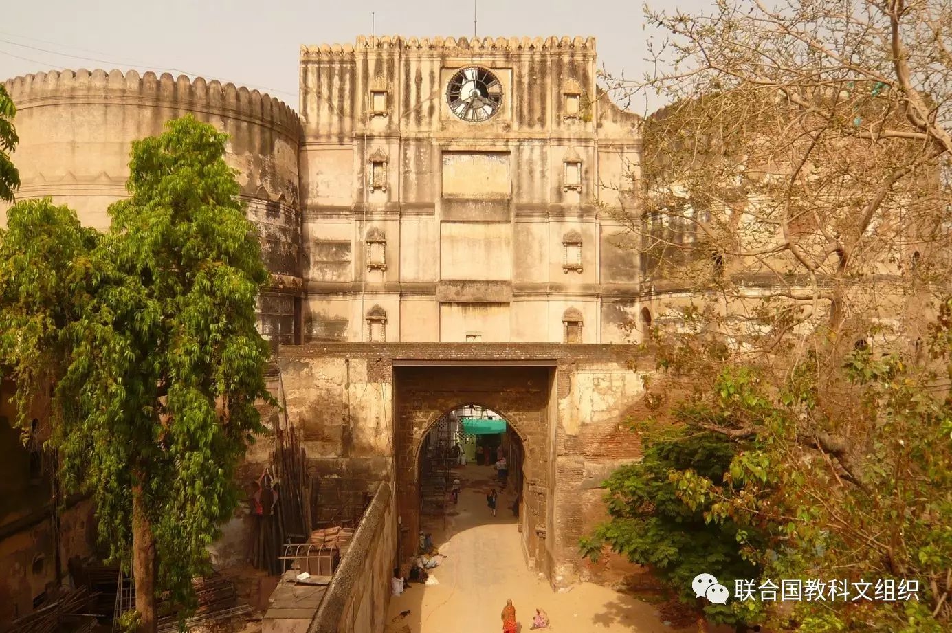 Entrance of Bhadra Fort © AMC
带有防御工事的艾哈迈达巴德是由艾哈迈德·沙阿苏丹于15世纪沿萨巴尔马提河东岸所建。它展现了苏丹时代的丰富建筑遗产,特别是巴达尔城堡、带有防御工事的城墙与城门、大量的清真寺和墓地以及其他时期印度教和耆那教的重要寺庙。城市的脉络由沿着封闭的传统街道密集排列的传统房屋所构成,街道的门以设有鸟的食盆或者公共水井为特点。这座城市在成为古吉拉特的首府以来至今天的六个世纪中一直保持着繁荣。
The walled city of Ahmadabad, founded by Sultan Ahmad Shah in the 15th century, on the eastern bank of the Sabarmati river, presents a rich architectural heritage from the sultanate period, notably the Bhadra citadel, the walls and gates of the Fort city and numerous mosques and tombs as well as important Hindu and Jain temples of later periods. The urban fabric is made up of densely-packed traditional houses (pols) in gated traditional streets (puras) with characteristic features such as bird feeders, public wells and religious institutions. The city continued to flourish as the capital of the State of Gujarat for six centuries, up to the present.
2亚兹德历史城区(伊朗伊斯兰共和国)
Historic City of Yazd (Islamic Republic of Iran)
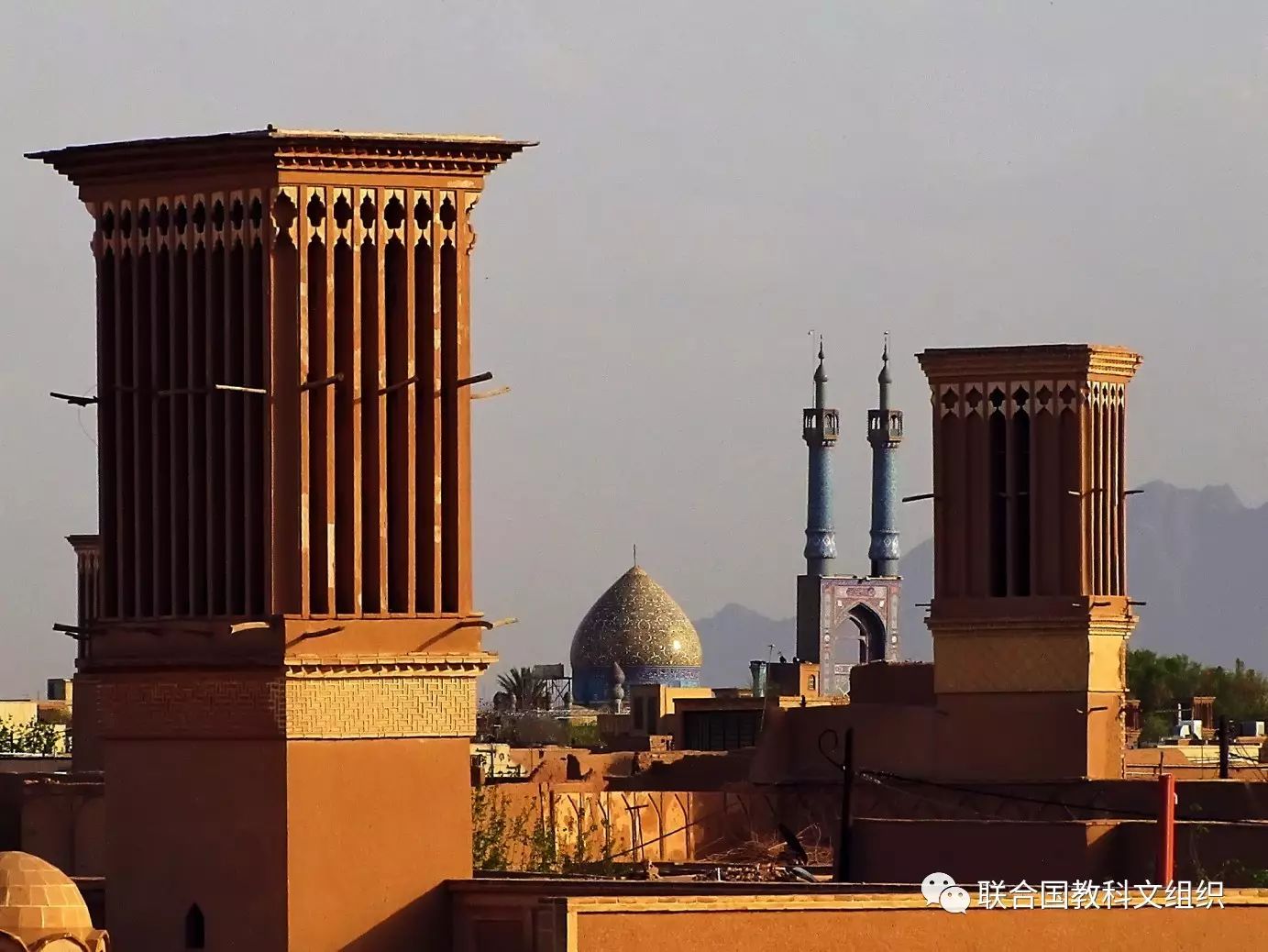 General View - Historic City of Yazd © ICHHTO
亚兹德历史城区位于伊朗中央高原的中心地带,伊斯法罕东南270公里处,离香料与丝绸之路不远的地方。古城是人类利用有限的资源在沙漠中幸存下来的鲜活例证。城市的用水是通过坎儿井系统——一种抽取地下水的设施被引到城市。在众多传统土制建筑的城市被现代化摧毁时,亚兹德这座同样是土制建筑的城市却有幸置身于这一潮流之外。这座城市及其传统的坎儿井系统、传统的房屋、集市、浴室、清真寺、犹太教堂、拜火教的寺庙以及多莱特阿巴德花园抵住了时间的考验。
The City of Yazd is located in the middle of the Iranian plateau, 270 kilomtres southeast of Isfahan, close to the Spice and Silk Roads. It bears living testimony to the use of limited resources for survival in the desert. Water is supplied to the city through a qanat system developed to draw underground water. The earthen architecture of Yazd has escaped the modernization that destroyed many traditional earthen towns, retaining its traditional districts, the qanat system, traditional houses, bazars, hammams, mosques, synagogues, Zoroastrian temples and the historic garden of Dolat-abad.
3‘神宿之岛’冲之岛及宗像相关遗产群(日本)
Sacred Island of Okinoshima and Associated Sites in the Munakata Region (Japan)
 Sacred Island of Okinoshima and Associated Sites in the Munakata Region: Miare Festival (land procession) © World Heritage Promotion Committee
该遗产群位于九州岛西海岸50公里外,冲之岛是神宿之岛祭祀传统的一个独特代表。这一考古遗址的保存极其完好,几乎没有变动,为展现4~9世纪举行祭祀活动的演变提供了完整的历史画面。在祭祀过程中,用于祈愿的供品会放置在岛上不同的地方。供品中有许多器件制作精美,来自于海外,见证了日本群岛、朝鲜半岛与亚洲大陆之间的紧密联系。作为宗像大社的一部分,冲之岛直至今日仍被视做神圣之地。
Located 60 km off the western coast of Kyushu island, the island of Okinoshima is an exceptional example of the tradition of worship of a sacred island. The archaeological sites that have been preserved on the Island are virtually intact, and provide a chronological record of how the rituals performed there changed from the 4th to the 9th centuries CE. In these rituals, votive objects were deposited as offerings at different sites on the Island. Many of them are of exquisite workmanship and had been brought from overseas, providing evidence of intense exchanges between the Japanese archipelago, the Korean Peninsula and the Asian continent. Integrated within the Grand Shrine of Munakata, the island of Okinoshima is considered sacred to this day.
4希伯伦/哈利勒老城(巴勒斯坦)
Hebron/Al-Khalil Old Town (Palestine)
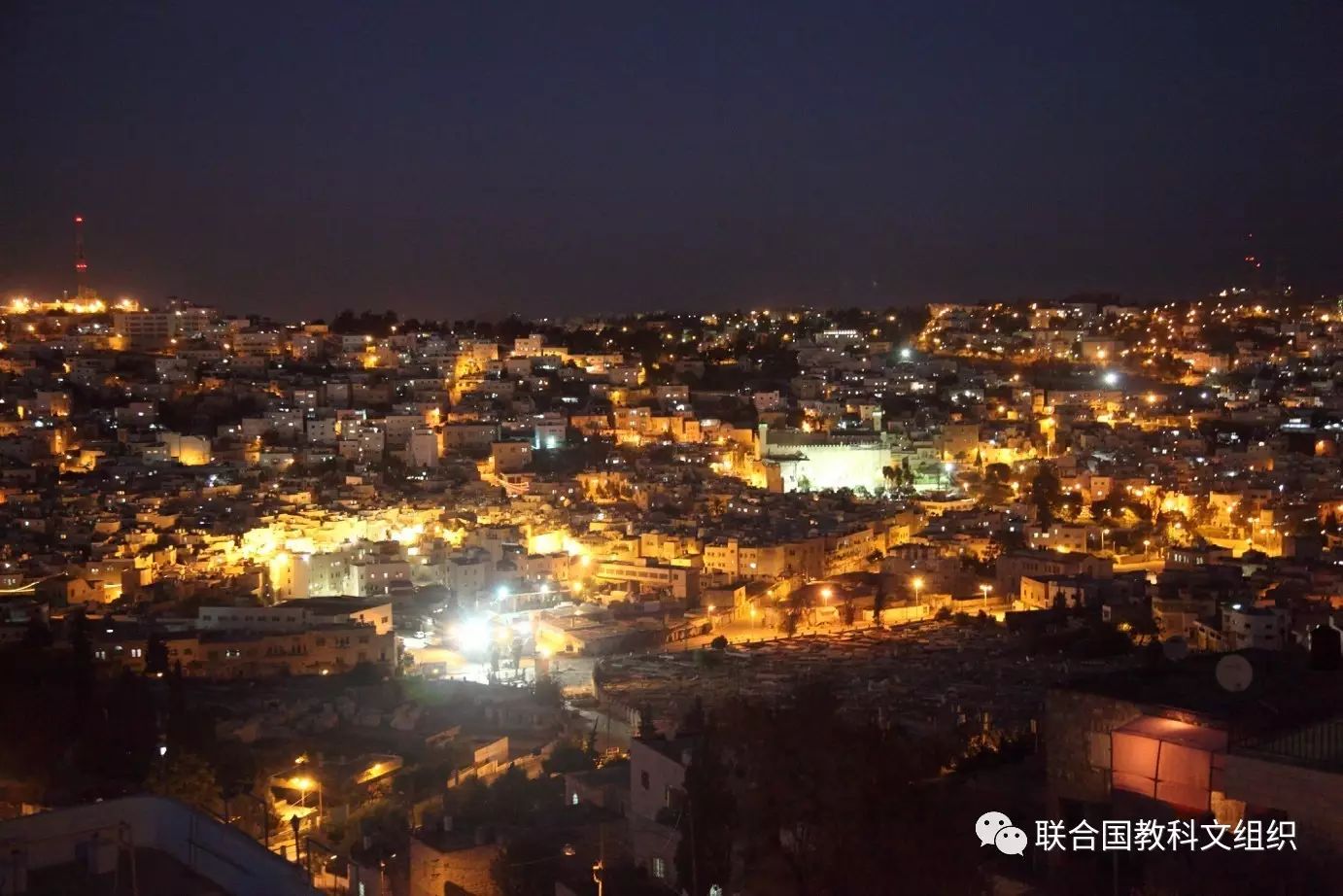 General view of Hebron Old City © Firas AL_Hashlamoun
1250年到1517年的马穆鲁克时期,希伯伦/哈利勒老城建筑中对当地一种石灰岩的广泛使用为老城的建设定下了基调。老城的中心建筑是易卜拉欣清真寺(伊斯兰教)/列祖之墓(犹太教)。这座复合式建筑建于公元一世纪,其目的是为了保护亚布拉罕/易卜拉欣及其家人的墓葬。此地也因此成为犹太教、基督教和伊斯兰教三教的朝圣之地。老城坐落于往来南巴勒斯坦、西奈半岛、约旦东部和阿拉伯半岛北部的商贸路线交界处。虽然在马穆鲁克时期以后的奥斯曼帝国时期(1517-1917),老城的范围大大拓展,建筑也变得更加多样化,如建筑高度增加以增添更多楼层,但总体而言,马穆鲁克时期对老城形态的影响持续至今,特别是地区的层级划分,按照民族、宗教和职业性质划分的区,以及房间呈树形排列的房屋。
The use of a local limestone shaped the construction of the old town of Hebron / Al-Khalil during the Mamluk period between 1250 and 1517. The centre of interest of the town was the site of Al mosque-Ibrahim / the tomb of the Patriarchs whose buildings are in a compound built in the 1st century CE to protect the tombs of the patriarch Abraham / Ibrahim and his family. This place became a site of pilgrimage for the three monotheistic religions: Judaism, Christianity and Islam. The town was sited at the crossroads of trade routes for caravans travelling between southern Palestine, Sinai, Eastern Jordan, and the north of the Arabian Peninsula. Although the subsequent Ottoman Period (1517-1917) heralded an extension of the town to the surrounding areas and brought numerous architectural additions, particularly the raising of the roof level of houses to provide more upper stories, the overall Mamluk morphology of the town is seen to have persisted with its hierarchy of areas, quarters based on ethnic, religious or professional groupings, and houses with groups of rooms organized according to a tree-shaped system.
5塔尔诺夫斯克古雷铅银锌矿及其地下水管理系统(波兰)
Tarnowskie Góry Lead-Silver-Zinc Mine and its Underground Water Management System (Poland)
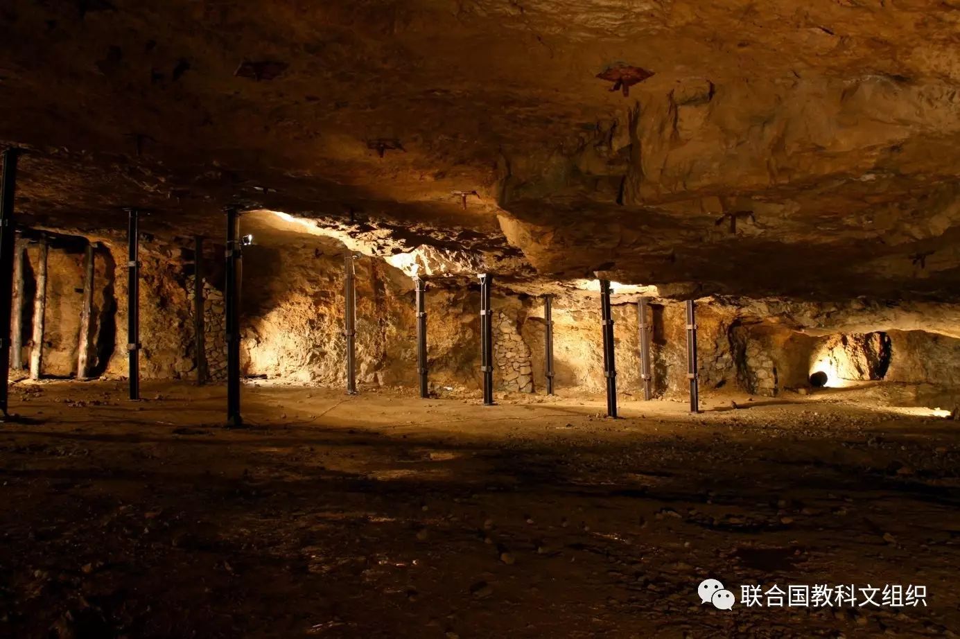 Multiple steel roof jacks installed during the second half of the twentieth century in the 'Silver Chamber' (Historic Silver Mine) © Tarnowskie Góry Land Lovers' Association
塔尔诺夫斯克古雷铅锌矿位于波兰南部、中欧主要矿区之一的西里西亚高原,遗址包括整个地下采矿网络及其中的坑道、水井、通道以及水管理系统等等。遗址的大部分都位于地下,但在地面上仍然保留着一些组成部分如19世纪的蒸汽泵站的遗迹。水利系统反映了三个世纪中为地下采矿的排水所付出的持续努力。这一系统把矿中有水的这样一个不利的状况转化成为用于满足城市及工业供水需要。塔尔诺夫斯克古雷为世界铅及锌的生产作出了重要的贡献。
Located in Upper Silesia, in southern Poland, one of the main mining areas of central Europe, the site includes the entire underground mine with adits, shafts, galleries and water management system. Most of the site is situated underground while the surface mining topography features the remains of the 19th century steam water pumping station, which testifies to continuous efforts over three centuries to drain the underground extraction zone. It has made it possible to use undesirable water from the mines to supply towns and industry. Tarnowskie Góry represents a significant contribution to the global production of lead and zinc.
6岛村斯维亚日斯克圣母升天大教堂与修道院(俄罗斯联邦)
Assumption Cathedral and Monastery of the town-island of Sviyazhsk (Russian Federation)
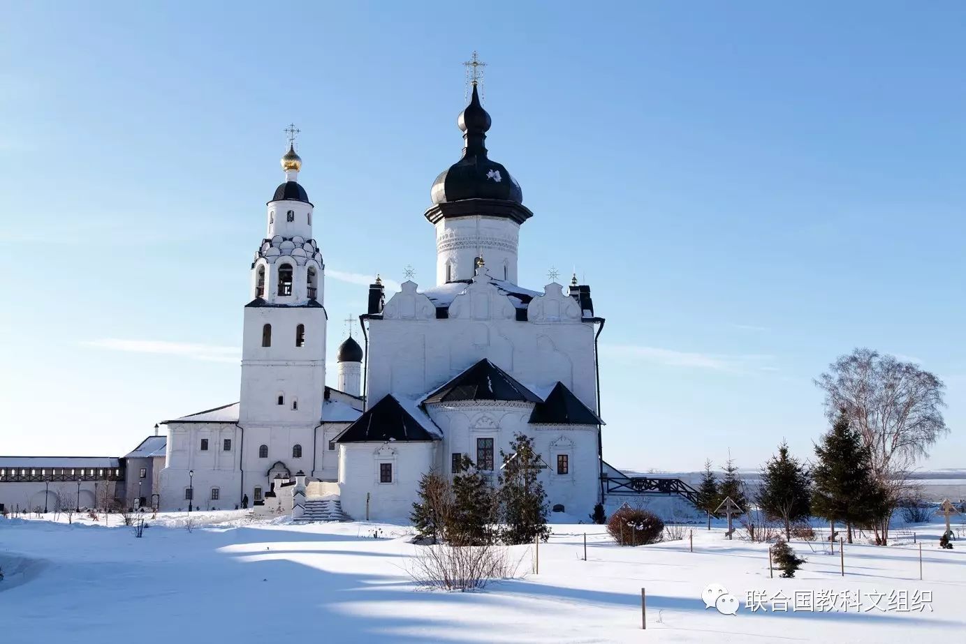 Assumption Cathedral. Eastern elevation © Regional Foundation of Revival of Historical and Cultural Monuments of Republic of Tatarstan
圣母升天大教堂位于岛村斯维亚日斯克的一所同名修道院中。斯维亚日斯克位于伏尔加河、斯维亚加河和希舒卡河的交汇处、丝绸之路与伏尔加的十字路口,恐怖的伊凡于1551年建造了这座城市。正是在这座前哨战,他启动了征服喀山的步伐。这座圣母升天修道院因其位置、建筑布局以及沙皇伊凡四世为扩张莫斯科公国开展的政治及传教计划而闻名于世。大教堂内的壁画是东正教壁画中极其罕见的作品。
The Assumption Cathedral is located in the town-island of Sviyazhsk and is part of the monastery of the same name. Situated at the confluence of the Volga, the Sviyaga and the Shchuka rivers, at the crossroads of the Silk and Volga routes, Sviyazhsk was founded by Ivan the Terrible in 1551. It was from this outpost that he initiated the conquest of the Kazan Khanate. The Assumption Monastery illustrates in its location and architectural composition the political and missionary programme developed by Tsar Ivan IV to extend the Moscow state. The cathedral's frescoes are among the rarest examples of Eastern Orthodox mural paintings.
7蔻玛尼文化景观(南非)
ǂKhomani Cultural Landscape (South Africa)
 Dancing around fire.ǂKhomani Cultural Landscape © Francois Odendaal Productions (FOP Films)
蔻玛尼文化景观位于南非北部与博茨瓦纳和纳米比亚的交界处,与喀拉哈里大羚羊国家公园地理位置有重合。广袤的沙漠承载着人类从石器时代以来直到现在的生活印记,并影响了从前游牧民族蔻玛尼萨恩人的文化和他们适应严酷沙漠环境的策略。他们发展出了一套与生活环境的地理特征密切相关的民族植物学知识、文化习俗和世界观。蔻玛尼文化景观是上千年以来当地人适应并塑造生活环境的真实写照。
The ǂKhomani Cultural Landscape is located at the border with Botswana and Namibia in the northern part of the country, coinciding with the Kalahari Gemsbok National Park (KGNP). The large expanse of sand contains evidence of human occupation from the Stone Age to the present and is associated with the culture of the formally nomade ǂKhomani San people and the strategies that allowed them to adapt to harsh desert conditions. They developed a specific ethnobotanical knowledge, cultural practices and a worldview related to the geographical features of their environment. The ǂKhomani Cultural Landscape bears testimony to the way of life that prevailed in the region and shaped the site over thousands of years.
8阿弗罗狄西亚(土耳其)
Aphrodisias (Turkey)
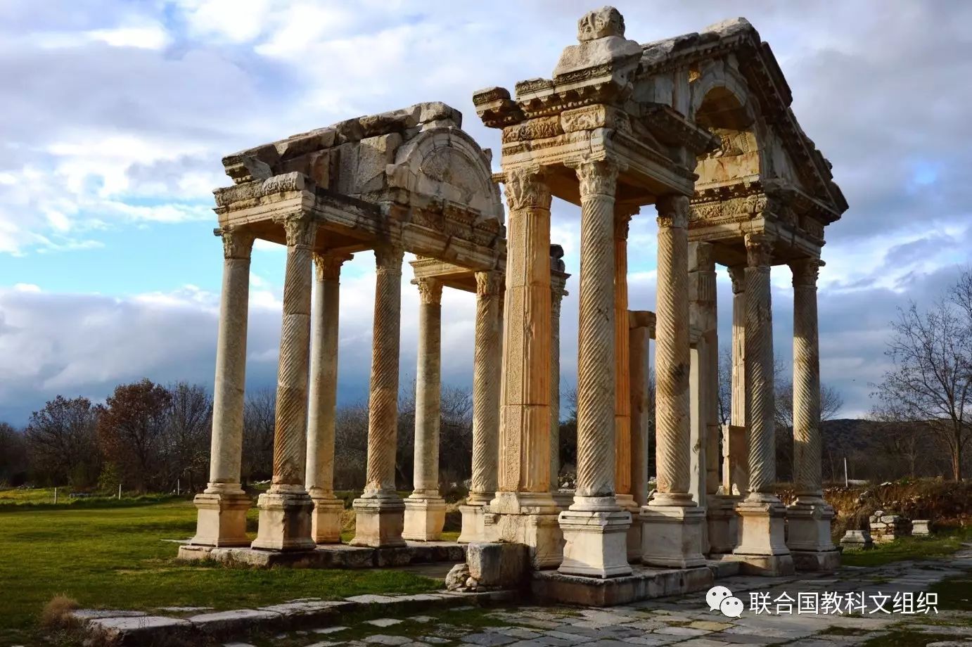 Aphrodisias: Tetrapylon © Aphrodisias Museum
这座遗址位于土耳其西南部的摩尔新努斯河上游的山谷中,由两个部分所组成:阿弗罗狄西亚考古遗址和城市东北的大理石采石场。这里的阿弗罗狄忒神庙可以追溯到公元前3世纪,而阿弗罗狄西亚城始建于公元前二世纪。城市的财富来自于采石场及城里雕刻家的艺术创作。这座城市是围绕着大型的市政建筑建设起来的,特别是神庙、剧院、广场及浴场。
Located in southwestern Turkey, in the upper valley of the Morsynus River, the site consists of two components: the archaeological site of Aphrodisias and the marble quarries northeast of the city. The temple of Aphrodite dates from the 3rd century BCE and the city was built one century later. The wealth of Aphrodisias came from the marble quarries and the art produced by its sculptors. The city streets are arranged around several large civic structures, which include temples, a theatre, an agora, and two bath complexes.
9英格兰湖区(英国)
The English Lake District (United Kingdom)
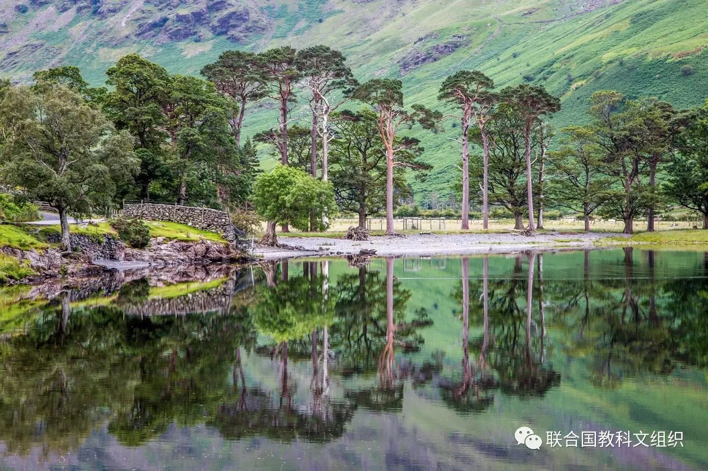 Buttermere reflections © Andrew Locking
英格兰湖区位于英国西北部,是一片山区,其中的山谷是冰川时代冰川塑造的结果,其面貌后来又受到农牧业的影响,比如这里极具特点的用墙围绕起来的田野。自然与人类活动的交互作用创造了一幅湖光山色相映成趣的和谐画面。为了增加此处的美景,人们在此还规划设计了显赫的庄园、花园和公园。自十八世纪以来,这里的景观特别受到风景派以及后来的浪漫派的喜爱,他们通过油画、素描及文学作品更令其声名远扬。这些启发了人们对自然风景重要性的认识,从而进一步激发了早期为保护景观所做出的努力。
Located in northwest England, the English Lake District is a mountainous area, whose valleys have been modelled by glaciers in the Ice Age and subsequently shaped by an agro-pastoral land-use system characterized by fields enclosed by walls. The combined work of nature and human activity has produced a harmonious landscape in which the mountains are mirrored in the lakes. Grand houses, gardens and parks have been purposely created to enhance the beauty of this landscape. This landscape was greatly appreciated from the 18th century onwards by the Picturesque and later Romantic movements, which celebrated it in paintings, drawings and words. It also inspired an awareness of the importance of beautiful landscapes and triggered early efforts to preserve them.