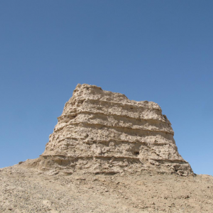
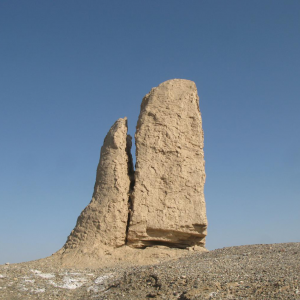
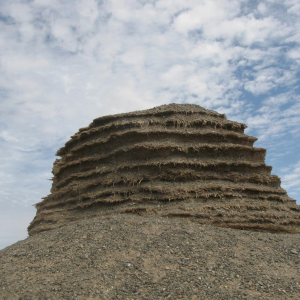
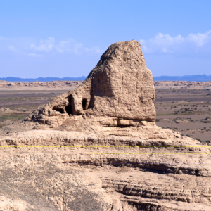
位于哈拉湖南岸的风蚀台地上,台地高约10米。
临泽燧: T23:287A简“临泽隧牛卯、襄泽隧长、临利隧长孙庆、禽寇隧长宋良、穷寇隧长张□”;T23:287B简“右前部隧亭”,右前部属肩水候官,襄泽燧、临利燧、禽寇燧、穷寇燧皆属肩水候官,故与之并列的“临泽燧”也应属肩水候官。
图阿达遗址位于乌兹别克斯坦拜松市西北6公里的图阿达村内。此地属西天山南麓山间峡谷地带,地势呈倾斜缓坡状,较为开阔,牧草丰茂,两侧谷地内均为河流。遗址区大部分被现代村落所占据,并遭到严重破坏,范围不明。在村落北侧边缘地带残存数座石构建筑基址,地表现存石筑墙基,由1~2列排列整齐的卵石围成,基本与地表平齐。绝大部分已不完整,其中保存最 ...
卡拉伊米尔(КалъааиМир)古城遗址卡拉伊米尔古城遗址位于塔吉克斯坦库尔干秋别市西南70公里的乔尔伯格镇内,地处河流左岸的台地上,四周皆是现代居民区。古城遗址位于高出周围地面十余米的大土丘上,平面近方形,边长约150米。其四周分布有断续的城墙,最高处残高4米,西墙可见土坯垒砌的痕迹。城墙外围有城壕,只有一个城门,位于西墙中部。城 ...
萨扎干(Sazagan)遗址萨扎干遗址位于乌兹别克斯坦撒马尔罕市西南20公里的萨扎干村中南部,地处西天山北麓萨扎干河谷地带的平坦台地和低缓山丘上,东为萨扎干河,北为河流出山的冲积扇,其余几面均被山丘环绕。遗址区大部分被现代村庄所占据,仅在边缘地带可见一些遗迹。在遗址区东部紧邻萨扎干河左岸处,发现有石构建筑基址群。其中央部位,分布有一座石 ...
萨扎干(Sazagan)墓地萨扎干墓地位于萨扎干村东侧2公里的西天山北麓坡地上,地势较为平坦开阔,牧草茂盛。在这里的山前地带发现数十座墓葬,大多为圆形的土石混合封堆墓,以石块混合土构筑封堆,中部有明显的凹陷,直径多为5~12、高0.3~0.5米。此外,墓地东北部还有3座高大的土墩墓,呈圆丘形,直径约30、高约4米。同样形态的墓葬在蒙古高原和新疆一带 ...
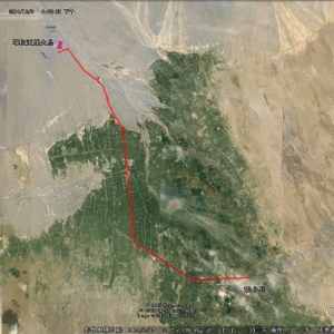
连城遗址连城遗址位于民勤县泉山镇团结村西北约12.5公里沙漠中。城平面呈长方形,长420米,宽370米,面积15万余平方米。城墙夯土版筑,残高7米,基宽4米,夯层厚0.1至0.15米。西墙开一门,门外有东西长24米,南北宽12米的瓮城,门向东。地表暴露大量灰陶片、碎砖块等。城内西门南侧有许多铜甲、铁甲残片、铁箭头等,城中东部铜质残渣集中,似铜器作坊,西 ...
窎沟古城址,位于距今芦阳镇东5公里处,经考证为汉朝武威郡媪围县城,是丝绸之路沿线规模最大的汉代县城遗址。城墙西南至东北角长250米,已坍塌成为高1米—1.5米的土垄,西南至东南角长310米,东北至东南角长140米的城墙依山形而建,墙体除东南角40米坍塌成高1米—2米的土垄外,其余已全部损毁。
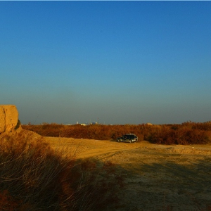
米兰戍堡位于米兰古城遗址的核心处,目前被圈围在几十平方公里保护区中,略呈三角形的保护区南侧,有已经被废弃的和田——敦煌公里通过。2014年寒冬的时候,沿孔雀河烽燧群从北往南做工作,在米兰镇驻扎了几天,主要是为了去墩里克烽燧,顺便参观了米兰遗址。皑皑白雪中,空寂无边的感觉,凸出的城堡、佛塔非常醒目。米兰古城遗址为全国重点文物保护单位, ...
察汉通古烽火台位于巴州和静县和静镇察汉通古村北约600米处,由东西相距数十米的两座烽火台组成,1988年第二次全国文物普查时登记为“察汗通古烽火台”,1997年公布为和静县重点文物保护单位时,定名为“和静县砖厂烽火台”,长城资源调查中则称“察汗通古东烽火台”和“察汗通古西烽火台”,年代为唐。两处烽火台距离如此之近实在难以理解,感觉似也不为 ...
四十里大墩烽燧马兰军事基地西门处,有条公路南下,路况极好,显见为国防建设重要保障之路。向南约15公里,道路西侧茫茫荒漠中小鼓包上有墩,名四十里大墩烽火台。好在荒漠中有为了植树和架设管道改良土地而开出的机耕道,才得以能进至烽燧前。该烽燧底部平面呈方形,边长6.8米,方向北偏东20°,顶部亦呈方形,边长4.6米。立面呈梯形,残高5.3米,为夯土 ...
从马兰沿324省道向西30多公里,亦或走吐和高速在塔哈其出口下道,路旁塔哈其乡查汗布呼小村中有塔哈其烽燧,2016年元旦当天,驱车前往观看,结果烽墩被围圈在农家院中,只能隔墙远观。据介绍,该烽火台为黄土夯筑而成,底部呈正方形,顶部呈圆角长方形,通高6.3米。底部边长12米,高2.5米,顶部东西长8米,南北宽6.5米,残高3.8米。中部被挖空改造为门朝南 ...
马蹄山烽火台位于喀什地区巴楚县恰尔巴格乡奥依阔塘村东8.8千米的乌库麻札塔格山东南端的山上。地处塔里木盆地西北边缘,山体裸露,缺乏植被。山下地势平坦,生长有胡杨、红柳、芦苇、骆驼刺、罗布麻等耐盐碱植物。东约40米为巴楚县至农三师51团的公路。烽火台因风雨侵蚀和人为盗掘而遭受严重破坏,顶部塌陷,有火烧痕迹。平面呈近正方形,土坯垒砌而成, ...
布滚鲁克烽燧位于且末县县城西北20公里处,315国道南侧约1.8公里处。烽燧处地表沙土,盐碱化严重,西侧较多红柳包,东侧多荒漠。烽燧位于红柳包地中一处较开阔的平地上,烽燧原体量较大,现多已塌圮,呈坚壳土堆状。从有关资料可知,烽燧平面略呈长方形,底边南北残长约17米,东西残长约15米,残高约5.5米。烽燧体中部为堆土或垛泥筑起,外部为夯土(或垛 ...
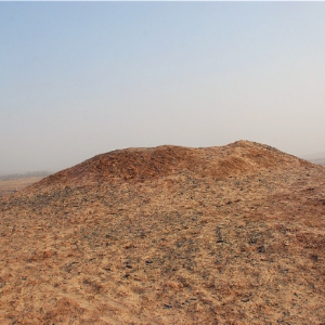
吾塔木烽燧位于且末县县城北部10公里处,315国道东侧,车尔臣河西侧,旁一麻扎地。地表沙土,盐碱化严重,生长有旱苇和骆驼刺等植物。烽燧位于国道和河谷之间的一处土丘包上,现烽燧整体已经塌实,地表残留一直径约9米,残高0.4-0.6米的圆形残迹。从局部可观察可见烽燧系垛泥筑法而建,其间夹杂有红柳枝和苇秆。1992年公布为县级文物保护单位。
吾塔木烽燧位于若羌县县城西北角,若羌河西侧,南部一棉花加工厂,东侧有公路通过。烽燧现为圆锥状,体量较大,底部直径近60米,残高约15-20米,土坯垒砌而成。烽燧整体光洁,表层坚硬,仅根部有部分骆驼刺生长,顶有一测量标志点和保护标牌,半腰处一方水泥柱墩。周边未见文物保护标牌和简介,南西北三侧皆为农田耕地,耕种和浇灌定会对其产生不利影响。1 ...
墩里克烽燧墩里克烽燧位于若羌县米兰镇(36团)东北方向38公里处,戈壁荒漠地区,南部约2公里处,旧和田——敦煌公里通过,现今公路已废。去往墩里克烽燧遗址,从米兰镇向南,抵315国道后向东行驶,在1464公里桩附近的玉石乡大桥西侧下道,或者在古楼兰桥西侧下道,沿河滩方向向北穿越戈壁滩,两处下道地点均有一高大的电讯铁塔。穿过戈壁后尚有一段沙丘沼 ...
米兰东北烽燧米兰遗址位于若羌县米兰镇(36团)东南角,在遗址中有两处有记载的烽燧建筑遗存,米兰西南烽火台ⅩⅦ和米兰东北烽火台ⅩⅦ。米兰西南烽火台ⅩⅦ位于整个米兰大遗址保护栅栏范围内。米兰东北烽火台ⅩⅦ位于遗址栅栏区外,单独用栅栏围护。米兰东北烽燧外观呈圆柱形,底面直径约3.5-4米,残高5米,西侧正中从上至下一凹槽。
营盘古城烽燧位于北山便道东端,南距34团约46.2公里。34团向北穿越沙漠,一条简易便道可抵营盘古城营盘古城烽燧和兴地山烽燧,原此地有甘草连,过度采摘后已致甘草资源接近枯竭,连队撤离,空余成片房舍,荒芜一片。原公益林保护站现驻扎有维族文保员,负责管理营盘古城机器墓葬区的安全。营盘古城烽燧东距营盘古城西门85米,周围地势平坦,红柳包林立。烽 ...
兴地山烽燧群位于北山便道东端,南距34团约46.2公里。34团向北穿越沙漠,一条简易便道可抵营盘古城和兴地山烽燧,原此地有甘草连,过度采摘后已致甘草资源接近枯竭,连队撤离,空余成片房舍,荒芜一片。原公益林保护站现驻扎有维族文保员,负责管理营盘古城机器墓葬区的安全。兴地山1、2、3号烽燧似应为三组佛塔建筑,南距营盘古城约3公里。三组建筑遗址呈 ...
苏伯斯坎烽火台位于新疆维吾尔自治区巴音郭楞蒙古自治州且末县塔提让乡托格拉克江杂勒村西北12干米。地处塔里木盆地南缘、车尔臣河中下游荒漠地带的红柳地中。地形平坦, 地势自西南向东北呈缓斜坡状, 地表为沙质碱土,盛长红柳、芦苇、甘草等植被。南距车尔臣河约0.2千米, 北约2千米为塔克拉玛干大抄漠。此地为托格拉克江杂勒村的草场, 为季节性放牧点 ...
下塔提让烽火台位于新疆维吾尔自治区巴音郭楞蒙古自治州且末县塔提让乡阿亚克塔提让村西北1.6千米。地处塔里木盆地南缘、阿尔金山北麓、车尔臣河三角洲平原塔提让乡西北部的绿洲与荒漠接壤地带。两侧各有一座较高大红柳包,四周地貌为固定、半固定沙土包和红柳包,生长有红柳、芦苇、胡杨等植被。南约1.9千米为车尔臣河。南、北面的洼地中有开垦的耕地,一 ...
千间房峰遂千间房烽燧位于218国道旁,659公里桩西侧300米左右。千间房烽燧为一大型的居住与烽火台相结合的建筑遗址,位于一道高约2.5米的土石梁尽头上。遗址规模较大,东西长约40米,南北宽约34米,残高2-4米。整个遗址外有墙垣,内有房舍,西北角部高耸为烽燧位置。【长城游记】新疆烽燧记略(1)东侧:较为完整,中部有豁口,上部受雨蚀破坏,表面溶蚀形 ...
哈曼沟路烽燧哈曼沟路烽火台位于焉耆回族自治县境内,在218国道千间房南烽火台处西行五公里后再南行1.6公路道旁。【长城游记】新疆烽燧记略(1)烽燧位于七个星佛寺遗址南部5公里处,东侧200米处一条三角铁架高压电线走廊,一条南北向水泥电杆高压线,一条简易道路从旁经过。周边为荒漠戈壁,地面遍布小石砾,北部2公里处多个砖瓦窑场,烟囱耸立。烽燧为南 ...
廷木墩烽燧廷木墩烽火台位于轮台县城南部约15公里处,自轮台县城中心沿文化路、文化南路南行,上240乡道后继续前行,上165省道(沙漠公路)继续南行约3公里,在沙漠公路14公里桩处,拐弯西行,穿过砖瓦窑场和田地可抵达廷木墩烽火台。【长城游记】新疆烽燧记略(1)烽燧东侧50米处,一条大沟,深2-3米,大沟东侧为棉花地,该沟似为垦荒排碱之用。烽燧北侧 ...
喀拉亚烽燧喀拉亚烽火台位于轮台县城西北部约27.8公里,位于一条古河道西侧的台地之上,四周戈壁茫茫,石砾遍地。自轮台县城沿314国道向西行驶(在县城部分该路段为交通西路),一段后向北拐行,穿过村镇和田野,直至河道和戈壁处,继续前行,穿过吐和高速公路后继续向西北方向行驶,数公里远即可见到戈壁高台上耸立的烽火台。喀拉亚烽火台位于迪那河古河 ...
拉依苏西烽火台位于新疆维吾尔自治区巴音郭楞蒙古自治州轮台县群巴克镇群巴克牧业村西约2.3千米。地处塔里木盆地北缘、天山南麓拉依苏沟洪积扇地带。地势自北向南倾斜,地表为粉沙质沉积黄土,盛长红柳等植被。东侧为耕地,东南侧为拉依苏遗址和拉依苏东烽火台、20千米为轮台县城,东北12.3千米为群巴克镇,北约3.5千米为314国道。烽火台因风雨侵蚀等自然 ...
苏贝希沟烽燧位于鄯善县吐峪沟乡苏贝希夏村西南沙石土山上,地处火焰山北麓的山崖上、吐峪沟西侧,周围地势险要。烽燧基础为黄土夯筑而成,几乎全部倒塌,中间残留高1米的土坯墙,四周为坍塌土所覆盖,形成直径约9米的堆积土。因该烽燧年代为清代,未算作长城资源。烽燧前部北侧为连霍高速东西通过,西侧为一条南北跨过吐鲁番火焰山的峡谷古道和一条县道, ...
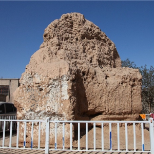
克黑墩烽火台是离龟兹故城西面最近的一座烽火台,距离仅千米。与空巴孜烽火台、伊西哈拉吐尔烽火台、沙卡乌烽火台一起构成龟兹故城四周的防御体系。烽火台呈方形,底边长约7米,顶边长约6米,底部为夯筑,上部为土块砌筑。新疆库车.克黑墩烽火台(自治区级文保)克黑墩烽火台为唐代所筑,下部是夯土,上面用土坯垒砌,现仅残存下部。这是当时都护府城防体 ...
阔空巴孜烽火台,唐,阿克苏地区,库车县伊西哈拉镇,古遗址 ,省保第六批
伊西哈拉吐尔烽火台位于新疆维吾尔自治区库车县伊西哈拉镇第二社区(村)北部。保护范围:遗址本体四周向外延伸50米;建设控制地带:保护范围向外延伸50米。2012年3月22日,新疆维吾尔自治区网站发布《关于公布新疆维吾尔自治区区级重点文物保护单位(第一批)保护范围建设控制地带的通知》,伊西哈拉吐尔烽火台被列为新疆维吾尔自治区区级重点文物保护单 ...
墩买力吐尔烽燧,汉-唐,阿克苏地区,库车县牙哈镇,古遗址,省保第六批
出处:按学科分类—历史、地理 新疆人民出版社《西域地名词典》第229页(198字)位于库车县牙哈乡克日希村东南约2公里,为晋至唐代城堡遗址。戍堡呈南北向坐落,东西长约100米,南北宽约12米。东墙仅留痕迹,南、西墙尚存,呈弧形,北面临河无墙。墙系砾石土堆砌成,基宽4米,高2米。戍堡西南角有一缺口,宽约2.5米,应为堡门。堡门外右侧有一土坯结构的 ...
盐水沟关垒遗址位于跨越却勒塔格山的217国道旁边小山包上,实为一扼守盐水沟关口的小戍堡,主要由四座墩台和一处居住址组成,分布在东西约1.5千米的范围内。1号墩台平面呈长方形,石块垒砌,基部南北5.5、东西4.6米,剖面呈梯形,高约3米;2号墩台石块垒砌,平面呈长方形,东西7、南北5、高约4米,中部被挖一个1米见方的坑;3号墩台石块垒砌,平面呈正方形 ...
伊吾前山阔吐尔肖纳烽燧,唐代 阔吐尔肖纳烽燧 : 位于伊吾县前山哈萨克民族乡北41公里,东经94°15′44″,北纬43°42′54″,海拔1 320米。烽燧坐落在阔吐尔肖纳牧点西侧的山顶上,地理位置十分重要,为唐代遗存,清代又增补使用。残高4.9米,底基烽体均系片石、树枝、木棍夹筑而成,近顶部树枝、木棍排列密集。烽燧东南3米处,有一片用石块垒砌的房舍,残高1米。阔 ...
巴里昆三塘湖烽燧,唐代三塘湖石板墩烽燧位于巴里坤三塘湖乡中湖村东南32千米的小山顶上,北约600米处为三塘湖乡至岔哈泉的公路,西北500米处为三塘湖石板墩西草滩,此处原有一眼泉水。烽燧西北距四塘泉烽燧11千米,东南距岔哈泉烽燧19千米。烽燧平面呈八边形,底边边长约3~4、残高约7米。烽燧内外分筑,外用石块垒砌,黄泥坐浆,南面已坍塌,从坍塌处发 ...
柳树泉的下马不拉克烽燧,唐代
柯坪县齐兰烽燧奇兰烽燧位于柯坪县阿恰乡奇兰村西南1.5公里的戈壁上,现残高约16米,烽燧底部呈方形,其外表呈梯形。烽燧顶部西南角已塌毁,东西和北面保存完好。齐兰烽燧四面全是开阔的沙漠平原,其南的喀什噶尔河冲积平原上曾经是野生动物的乐园,汉朝时这里曾经是一处烽台,唐朝蔚头州建立后又对其进行了加固和增高,使其成为雄踞大漠,观察四方的巨大 ...
拉克苏木烽燧位于哈密二堡,唐代烽燧拉克苏木烽燧 : 位于哈密市二堡乡拱拜尔湾村西南约4公里,东经43°16′33″,北纬43°56′33″,海拔756米。 烽燧为唐代遗迹。系土坯、红柳枝、芦苇等夹筑而成,残高近8米,底座边长约13米。采集遗物为夹细砂红陶残片。此烽燧是现存距哈密市最后一座。 哈密拉克苏木烽火台呈四棱台状, 正剖面呈梯形。残高7~8米,基底平面为正 ...
牛头墩东北长城
显明燧长城
广汉燧长城
敦煌汉长城当谷隧段近景
四墩窑五号墩
四墩窑二号墩
四墩窑一号墩
清水沟南墩
山阙峰烽燧保护范围山阙峰烽燧:以烽燧四周底边为基准,向东、南、西、北各延伸30米。
清水沟墩
青堆燧
南湖头墩
南湖二墩
牛涎水墩
牛头墩
卡子墩
碱墩
海子湾东石墩
马迷兔墩
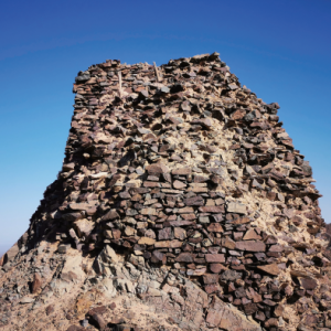
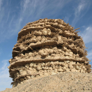
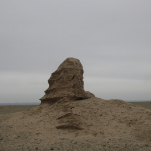
广武燧 俗称吐火洛墩 斯坦因编号T5位于T6a东北约8.2公里、吐火罗泉湖滩的北部沙梁上。广武燧(N:40。14.252`,E:93。20.371`。海拔约:949M),位于崔木头沟下游入沼泽前河段北岸。捡得木橛两个,房屋木构件四个,绳一节,麻布片三块。燧下曾挖得婴尸。棺形为一截胡杨木,中掏空,两头堵上,裹婴尸之布帛亦存。
高望燧
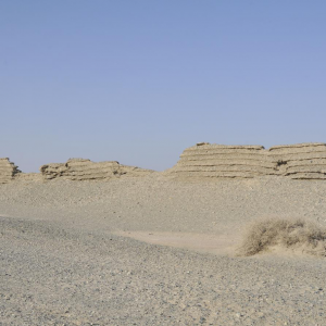
广昌燧斯坦因编号T6d 俗称弯腰墩,烽燧座落于高约11米的台地上,台地呈圆形。四周为湖滩,遍布芦苇、骆驼刺、红柳、甘草、白刺。胡杨等。
富昌燧
二十里大墩
墩子湾墩
东碱墩
大坡墩
墩墩山烽火台位于新疆维吾尔自治 区哈密地区哈密市沁城乡头宫村南约0.5 千米墩墩山顶 地处东天山南麓沁城盆 地中,东约50米为一条自北向南流的小 河,附近有五户居民,烽火台所在山脚 下有一条南北向的公路 因风雨侵蚀和人为破坏对烽火台 造成极大损坏 烽火台平面略呈圆形, 外包砌石块,中间填有石块和土,每隔 0.3-0.35米夹筑有一层木棍及细枝条 底部直 ...
崔木土沟墩
仓亭燧
臭墩子烽燧
步昌燧
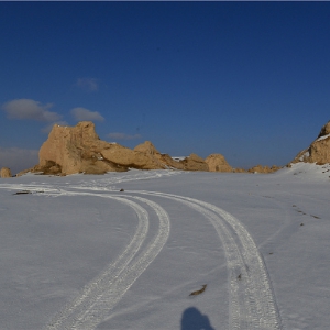
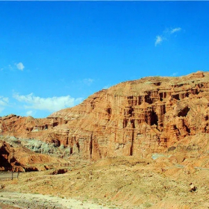
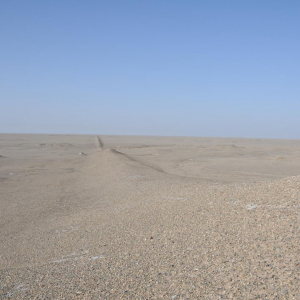
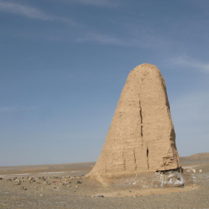
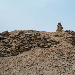
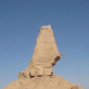
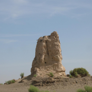
冰草湖西墩,斯坦因编号T22d位于哈拉湖南岸的风蚀台地上,台地高约10米,是突入湖中风蚀台地群中最北端、亦最高的台地。
清水沟烽燧
Disclaimer The Tentative Lists of States Parties are published by the World Heritage Centre at its website and/or in working documents in order to ensure transparency, access to information and to fa
Justification of Outstanding Universal ValueGenerally, citizens' affection for an urban space originates from their good memories. In fact, the city acts like a vessel in which such memoirs take shape
Justification of Outstanding Universal Value The Architecture style of Tehran University was inspired by European style and combined with the traditional Iranian Architecture, therefore, the modern m
伊朗纵贯铁路联通该国东北部的里海和西南部的波斯湾,穿越2座山脉以及众多河流、高原、森林和平原,跨4个气候区。这条全长1394公里的铁路始建于1927年,于1938年竣工,其设计和建造是伊朗政府与来自多个国家的43家建筑承包商成功合作的结果。这条铁路以其规模和克服陡峭路线和其它困难所需的工程而闻名。崎岖的地形导致铺设工作涉及多处大规模的山体切割, ...
Disclaimer The Tentative Lists of States Parties are published by the World Heritage Centre at its website and/or in working documents in order to ensure transparency, access to information and to fa
Statements of authenticity and/or integrity This area has some endemic plant species e.g. Astragalus kavirensis, A.touranicus, A. ulothrix, Cousinia mashhedensis, C. lasiandra, Eremostachys hyoscamoi
Disclaimer The Tentative Lists of States Parties are published by the World Heritage Centre at its website and/or in working documents in order to ensure transparency, access to information and to fa
Description One of the basic and essential needs of humans concerns the possession of a safe shelter, a need which since pre-historic era has been with them up to now. This basic need has been met in
Justification of Outstanding Universal Value Generous nature of Bakhtiari (Mid Zagros) provides the mankind with all they need for living: I. Providing their most needed things andprotecting against
Disclaimer The Tentative Lists of States Parties are published by the World Heritage Centre at its website and/or in working documents in order to ensure transparency, access to information and to fa
Disclaimer The Tentative Lists of States Parties are published by the World Heritage Centre at its website and/or in working documents in order to ensure transparency, access to information and to fa
担寒 : 西域地名。见于《西使记》。《元史·郭侃传》作檐寒山。在里海东南,今伊朗北部之达姆甘(Damghan)。Disclaimer The Tentative Lists of States Parties are published by the World Heritage Centre at its website and/or in working documents in order to ensure transparency, access to information and to f
Disclaimer The Tentative Lists of States Parties are published by the World Heritage Centre at its website and/or in working documents in order to ensure transparency, access to information and to fa
Disclaimer The Tentative Lists of States Parties are published by the World Heritage Centre at its website and/or in working documents in order to ensure transparency, access to information and to fa
Disclaimer The Tentative Lists of States Parties are published by the World Heritage Centre at its website and/or in working documents in order to ensure transparency, access to information and to fa