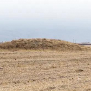
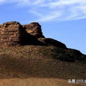
• The Great Wall of Gorgan
Justification of Outstanding Universal Value The Gorgan Plain with its defensive monuments of the Sassanid era(5th-7th centuries) constitute the greatest cluster of military monuments known from anyw
Justification of Outstanding Universal Value The Gorgan Plain with its defensive monuments of the Sassanid era(5th-7th centuries) constitute the greatest cluster of military monuments known from anyw
Disclaimer The Tentative Lists of States Parties are published by the World Heritage Centre at its website and/or in working documents in order to ensure transparency, access to information and to fa
豪拉曼/乌拉玛纳特文化景观处在偏远山区的豪拉曼/乌拉玛纳特景观展现了豪拉曼人的传统文化,这个库尔德农牧部落自公元前3000年以来一直居住在这里。该遗产地位于伊朗西部边陲库尔德斯坦省和克尔曼沙赫省的扎格罗斯山脉腹地,由两部分组成:库尔德斯坦省的山谷中东部(扎韦鲁德和塔赫特)和克尔曼沙赫省的山谷西部 (拉洪)。这里的居民几千年来生活在恶劣的山 ...
Description This historical complex has been situated on a natural base along with unique characteristics. The complex contains the castle of Izadkhast, one caravanserai and the Safavid-period bridge
Justification of Outstanding Universal Value I. Strategic location, skillful and proper link to high mounts, constructed on hard rocks, proper location for watching out arduous narrow path and valley
Disclaimer The Tentative Lists of States Parties are published by the World Heritage Centre at its website and/or in working documents in order to ensure transparency, access to information and to fa
Description Tape Sialk consists of two mounds known as Northern and Southern Sialk, located about 600 meters apart. The artifacts of the northern mounds are more ancient than those of the southern.
在印度戒日王朝时期,公元612年开始被定为都城。名称的来历,玄奘《大唐西域记》卷五记述:往时都城称拘苏摩补罗(梵文Kusumapura音译,意译华宫),王名梵授,生有千子、百女。时有一仙人,称大树仙人,居恒河侧。见王女来河滨游玩,遂起染着心,乃诣华宫,欲乞得一女。然王女等不愿嫁此一貌如枯木之仙人。时,王恐累及其国,乃送一稚女。唯仙人见稚女不 ...
七叶窟(Saptparni Cave) 第一次佛经结集地。
竹林精舍(Kalandaka Venuvana) 佛陀雨季结夏安居的寺院。
灵鹫山(Gridhakata Hill) 佛教圣地,中国古代的高僧法显、玄奘、义净都到这里参拜和居住过。
桑卡西亚(Sankasya)是佛陀讲道的地方
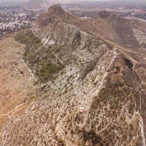
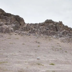
苏莱曼山岩画苏莱曼山岩画分布于奥什市中心的苏莱曼山上,苏莱曼山高 191.3 米,由 5座山峰绵延组成,共长 1663 米。据统计,岩画数量共 101 幅,图案除了大宛天马之外,还有羊、人物等。山顶建巴布尔之屋,山下建清真寺及博物馆。苏莱曼山航拍苏莱曼山岩画
阿尔马赫山岩画岩画位于阿尔马赫山,距奥什西北约 7 公里处。在此处发现有 30 多处岩画及 1 处人工雕凿的细密圆形孔洞,据吉方学者推测,雕凿孔洞应该是一种祭祀的方式。岩画内容以马为主,呈直立状,颈部与四肢细长,马尾外翘。除此之外还刻有羊和鹿的形象。阿尔马赫山阿尔马赫山岩画局部 ... ... ...
艾尔克卡什卡铭刻艾尔克卡什卡铭刻位于艾尔克卡什卡村南部约 2 公里处的山谷中,距离奥什西南约 26 公里。铭刻在山谷西侧的岩壁上,山谷中有一条河,水流湍急,没有桥梁,因此只能从远处观察。铭文约有 4 处,字母较大。从地形来看,周围的山谷中只有这里有河流,沟通了不同的地区,这可能是这一处铭刻选址的重要原因。除了粟特文的铭刻,似乎还有阿拉伯文 ...
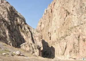
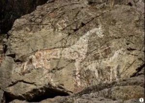
阿拉万岩画阿拉万岩画位于阿拉万村东侧的一座山上,山下现在为一片穆斯林墓地和清真寺。刻有岩画的岩石高约 10 米,画面上可清晰看见 2 匹马的形象,是典型的大宛天马的形象。岩画山岩下的石头上有人工雕凿的圆形孔洞,这是一种祭祀的方式。除了天马形象的岩画,此处还有其他时期的岩画和铭刻,但是由于时间原因没有勘察。阿拉万岩画
贝洛沃德斯科墓地贝洛沃德斯科墓地位于比什凯克西约 45 公里,墓葬分布在道路边上的农田中。墓葬形制较大,数量超过 20 座,呈直线排列。墓葬上方多为圆形封土,直径20—30米。据吉方学者介绍,楚河流域和天山周围发现大量这一类型的墓葬,其中部分经过发掘后认定为乌孙时期墓葬。贝洛沃德斯科墓葬封土
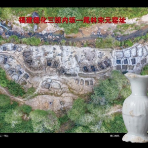
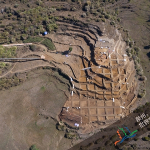
福建德化三班内坂—尾林宋元窑址为配合“泉州:宋元中国的世界海洋商贸中心”申遗工作,泉州市考古队于 2016 年 7月、2019 年 9月分两阶段对福建泉州德化县三班内坂—尾林区域进行考古调查、勘探。内坂山和尾林山位于三班镇上潦溪两岸,上潦溪穿过尾林、内坂、大垄口、梅岭山脚下,注入大云溪,两岸山坡上分布着众多的宋元明清乃至民国时期的窑址和堆积, ...
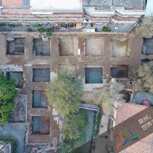
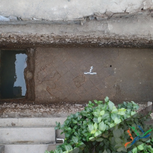
南外宗正司遗址南外宗正司遗址出土的建筑构件南外宗正司是1130年以来迁居泉州的宋代皇族群体的管理机构。这一群体是泉州多元社群中具有影响力的组成部分之一,他们不仅提升了泉州的消费能力,还积极参与海洋贸易。南外宗正司的设置进一步强化了国家政权对泉州海洋贸易的推动,体现了强有力的官方管理保障。它与泉州文庙及学宫、开元寺、老君岩、清净寺、伊 ...
泉州市舶司设置于1087年,是宋元国家政权设置在泉州管理海洋贸易事务的行政机构,其设置标志着泉州正式成为开放的国家对外贸易口岸,对宋元泉州的经济繁荣、文化交流以及海洋贸易各参与方的共同发展具有至关重要的意义,反映出泉州港口依托于庞大帝国的独特属性。市舶司遗址地处泉州城南部的晋江江畔,位于泉州古城罗城的镇南门外、翼城的南薰门内。根据已 ...
冶铁遗址安溪青阳下草埔冶铁遗址是宋元时期泉州冶铁手工业的珍贵见证,与泉州的陶瓷生产基地共同显示出宋元泉州强大的产业能力和贸易输出能力。遗址位于泉州西北约70公里的戴云山区。安溪县青阳村曾是宋代官方设立的专职铁场之一,是泉州内陆腹地的重要铁矿分布区,文献记载其冶铁业在11世纪时极为兴盛。安溪青阳下草埔遗址位于青阳村南部的山坡上,面积约 ...
Justification of Outstanding Universal Value The Silk Route networks and all properties -providing different kinds of services- that have been situated all along this route met the following criteria
Disclaimer The Tentative Lists of States Parties are published by the World Heritage Centre at its website and/or in working documents in order to ensure transparency, access to information and to fa
Justification of Outstanding Universal Value Not anywhere in the world, such cumulative of salt domes can be seen. Only in the southern part of the Zagros Mountains, there are more than 130 salt dome
Disclaimer The Tentative Lists of States Parties are published by the World Heritage Centre at its website and/or in working documents in order to ensure transparency, access to information and to fa
Description Qeshm is the biggest island in the Persian Gulf near the straits of Hormoz. It is stretched closely along sides the south coastline (Hormozgan) of the Iranian mainland. The highest elevat
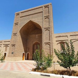
Description The Caravanserais are one of the most important form of Persian Architecture that emerged and created cause of routes development and needs related to the travel’s demands and requirement
Description Persepolis is one of the three properties included in the World Heritage List in 1979, belonging to the Achaemanid dynasty and is the most complete architectural form and city planning of
Justification of Outstanding Universal Value Troglodytic architecture of Karaftoo complex, carved in special and creative structure in 4 floors, including 9 rooms, corridors and passageways connectin
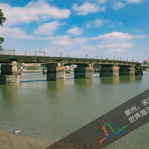
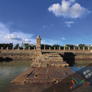
顺济桥遗址顺济桥是泉州古城与晋江南岸的陆运节点,是伴随海洋贸易发展而建设的出入古城商业区的主要通道,完善了泉州的水陆转运系统。它与德济门遗址、天后宫共同体现了海洋贸易推动下古城南部商业性城区的发展,见证了商业拓展对交通系统的促进。顺济桥遗址位于泉州古城南门德济门外,横跨晋江两岸,以近顺济宫(天后宫)而得名。顺济桥由南宋泉州郡守邹 ...
文兴码头美山码头江口码头位于泉州古城东南的晋江北岸,是连接古城的水陆转运节点,与真武庙同为泉州城郊的重要内港“法石港”的遗存,反映了内港码头的功能构成和使用方式。它与石湖码头、六胜塔、万寿塔等共同体现了宋元泉州由内港码头、外港码头、航标塔等共同构成的河海运输网络。江口码头现保存有文兴码头和美山码头两处码头及一处宋代古船遗址。两处 ...
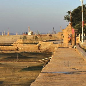
石湖码头 位于古泉州港南郊石狮市蚶江镇石湖村半岛上的石湖码头,是泉州古代商贸的重要码头和海防重地,相传为唐开元年间(713—741 年)航海家林銮创建。北距泉州城区 27公里,呈曲尺状,南北走向,全长 113.50 米,曲体长 70 米,宽 2.20 米,高 2.41 米,为花岗岩条石顺海岸砌筑而成。 北宋熙宁元年(1068年),因石湖东北面正对着泉州湾主航道的出海 ...
真武庙,俗称上帝宫,位于泉州丰泽区东海镇法石村石头街。祀真武大帝(北极玄天上帝),始建于南宋,占地面积3000多平方米。现存真武庙为明清建筑,坐北朝南,依山拾级而上,两旁扶栏石柱皆雕石狮,十分古朴。中轴线上有山门、拜亭、大殿。建筑面积400平方米。庙前有露庭,古榕蔽荫,微风习习,原为泉州一大胜境。寺庙历史真武庙,俗称上帝宫,位于泉州丰 ...
万寿塔 姑嫂塔(又称万寿塔、关锁塔)位于石狮市东南宝盖山上,建于南宋绍兴年间,是古代泉州海上交通的导航标志,“关锁烟霞”为泉州一大胜景,福建省文物保护单位。 姑嫂塔,又称“关锁塔”或“万寿塔”,它建于南宋绍兴年间的公元1131-1162年,迄今已经有800多年的历史了。它背靠泉州湾,面临台湾海峡,有镇南疆而控东溟之势。《泉州府志》上称它“关 ...
天后祖祠位于莆田市湄洲湾北岸山亭乡,古称:贤良港,亦名“黄螺港”,是海峡女神妈祖的诞生地,妈祖羽化后,乡人建祠纪念。 祖祠始建于宋代,祀妈祖木室像。据《敕封天后志》载:“世传祠内室像,系异人妆塑,各处供奉之偈,皆不能及”。因祠内前殿供大会供奉妈祖室像。额称“天后祠”,后殿供奉圣父母及其先代牌位,额称“林氏祖祠”,故尊为“天后祖祠 ...
月港位于福建漳州,是明朝中后期“海舶鳞集、商贾咸聚”“农贾杂半,走洋如适市,朝夕皆海供,酬酢皆夷产”的著名外贸通商港口。月港地处九龙江入海处,因其港道(海澄月溪至海门岛)“一水中堑,环绕如偃月”,故名月港。它与汉、唐时期的福州港,宋、元时期的泉州港,清代的厦门港,并称福建历史上的“四大商港”。月港弥漫着海洋文化的氛围。这里自古就有 ...
Description An ensemble of historic, religious and artistic works from the Achaemenian and Sasanian periods located within a small perimeter near the monuments of Persepolis and those of the pre-Sasa
Comparison with other similar propertiesThe monastery of St. Amenaprkich in new Julfa use different types of Architectural elements and construction materials depending on the region where it is locat
Disclaimer The Tentative Lists of States Parties are published by the World Heritage Centre at its website and/or in working documents in order to ensure transparency, access to information and to fa
Description This valley has been situated in the central heights of Luristan and at heart of limy mounts. Because of abundant water reservoirs and different types of plants and animals, suitable weat
Disclaimer The Tentative Lists of States Parties are published by the World Heritage Centre at its website and/or in working documents in order to ensure transparency, access to information and to fa
Comparison with other similar properties There exist a lot of ancient fortresses all around the country .Although these fortresses share some common features, they are considered unique. If there was
Disclaimer The Tentative Lists of States Parties are published by the World Heritage Centre at its website and/or in working documents in order to ensure transparency, access to information and to fa
Disclaimer The Tentative Lists of States Parties are published by the World Heritage Centre at its website and/or in working documents in order to ensure transparency, access to information and to fa
Disclaimer The Tentative Lists of States Parties are published by the World Heritage Centre at its website and/or in working documents in order to ensure transparency, access to information and to fa
Justification of Outstanding Universal Value During the appearance of methods and modern tools, development of technology and mass production, society has changed from agricultural to the industrial
Justification of Outstanding Universal Value Imam Reza’s holy shrine is the most significant element giving identity to the urban area of Mashhad. The city is of exceptional examples formed based on
Disclaimer The Tentative Lists of States Parties are published by the World Heritage Centre at its website and/or in working documents in order to ensure transparency, access to information and to fa
Disclaimer The Tentative Lists of States Parties are published by the World Heritage Centre at its website and/or in working documents in order to ensure transparency, access to information and to fa
Disclaimer The Tentative Lists of States Parties are published by the World Heritage Centre at its website and/or in working documents in order to ensure transparency, access to information and to fa
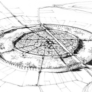
Justification of Outstanding Universal Value I. Hegmataneh is located in suburban area of Hamedan. It contains 50 acres of the city of Hamadan. This valuable historical collection is of great archeol
Justification of Outstanding Universal Value This natural reserve is unique between mangrove habitats in west Asia because of vast area and adapted to hot weather and more saline sea water (over 40 p
Disclaimer The Tentative Lists of States Parties are published by the World Heritage Centre at its website and/or in working documents in order to ensure transparency, access to information and to fa
Disclaimer The Tentative Lists of States Parties are published by the World Heritage Centre at its website and/or in working documents in order to ensure transparency, access to information and to fa
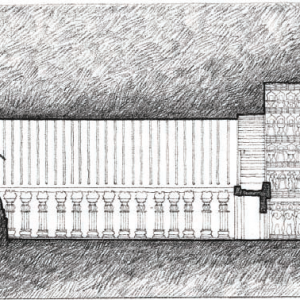
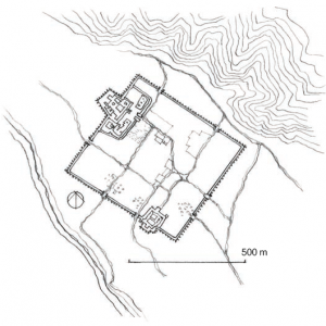
Description The ensemble at Firuzabad comprises, within a 12 km diameter area, such archaeological sites as the City of Gur, the Palace of Ardashir (Atashkadeh), Qal'eh Dokhtar fortress, bas reliefs
Disclaimer The Tentative Lists of States Parties are published by the World Heritage Centre at its website and/or in working documents in order to ensure transparency, access to information and to fa
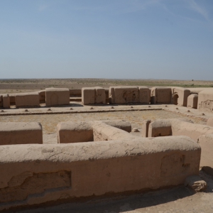
Description Hassan Sabah's castle has been located in northeastern side of Gazor Khan Village in the environs of Mo'alem Kalayeh, from the environs of Roudbar of Alamout. The relics of castle stand o
上川岛地处中国广东省江门市台山市西南部,屹立于南海之中,其东邻港、澳地区及珠海经济特区,距香港、澳门分别为87海里和58海里,距大陆山咀码头为9.8海里。中文名台山上川岛开放时间全天开放门票价格158.00元占地面积157 km2著名景点方济阁墓园建议游玩时长半天适宜游玩季节3-4月、10-11月基本信息上川岛岛屿面积为157平方公里,拥有十二处总长达三十多 ...
南海一号古船是南宋初期一艘在海上丝绸之路向外运送瓷器时失事沉没的木质古沉船,沉没地点位于中国广东省。对“南海Ⅰ号”出水的众多生活物品类文物,国家文物局原副局长黄景略曾给予高度评价:“出海远航的船是一个单一性社会,人们会把那个年代最必需的生活用品带上船。这种高度浓缩过的历史标本将使我们洞察当时的贸易方式和生活方式,并且提供地面上无 ...
松口古镇,是明末以后客家人出南洋的第一站,也是孙中山发动辛亥革命的策源地之一,位于广东省梅州市梅县区松口镇,地处梅县区东北部、梅江下游,临近粤闽赣三省省际。松口古镇是历史上的商贸重镇,有着“自古不认州”的盛名。临近的松口港曾为广东内河的第二大港。松口古镇被深深地刻上了南洋文化的烙印,如松口的街道属于中西结合的风格,在明末清初时便 ...
郑和墓位于南京市江宁区牛首山南麓,墓形为回字形,南北走向,为江苏省文物保护单位。因郑和之父名马哈麻,人称马哈只,当地人以为郑和原姓马,故称为“马回回墓”。墓冢所在之山,亦称为“回回山”。墓圹呈长方形,长约150米,东西宽约60米,墓顶高约8米,墓前台阶有四组7层28级,寓意郑和七次下西洋,历时28年,遍访40多个国家和地区。墓盖下部雕饰祥云 ...
洪保墓位于南京市江宁区祖堂山,由南京市博物馆在南京祖堂山社会福利院抢救性考古发掘了明代太监洪保墓,这位太监曾是郑和下西洋船队的副使。陵墓文物大缸直径一米的大缸是长明灯在很多传说和故事里,古墓里都有长明灯。这种说法有没有根据?南京祖堂山明代太监洪保墓考古给出了肯定的回答。直径1米的大缸就歪倒在前室墓门处,其实它就是一个大油灯。“本 ...
樟林古港,位于广东省汕头市澄海区东里镇,始建于明嘉靖三十五年(1556年),占地2平方千米。樟林古港是历史上粤东第一大港,唐代是个海滨渔村,因樟树成林而得名,几经沉浮。康熙二十三年(1684年),因正式放开海禁,樟林港埠商人纷纷造船出海。形成以“六社八街"为中心的商业规模,即港埠中心的仙桥、长发、古新、广盛、顺兴、洽兴、永兴、商园等8道 ...
赤湾港区,早在唐宋时期已十分活跃,是“海上丝绸之路”上的一个重要港口。这是日前深圳考古学者经大量调查考证后得出的结论,为深圳申报“中国历史文化名城”提供了新的证据。据深圳市博物馆副馆长、中国考古学会会员杨耀林研究员介绍,唐朝以来,广州对外贸易日益繁盛,深圳作为广州海外交通的重要门户,对外经贸活动也活跃起来。深圳近年出土了大量的宋 ...
深圳鲨鱼涌古港在明代就是一个渔港。这里是大鹏新区现存19个具有保护利用价值的古村落之一。明代时,鲨鱼涌曾经是惠州、东莞、宝安三地最大最旺的港口,最繁华的商品集散地,当年被人们称为“小北京”。街道两边少数仅存的明清古建筑,因为年久失修,多已残破,有的已列为危房。
赤湾天后宫,也叫天后博物馆,坐落在广东省深圳市南山区赤湾村旁小南山下,倚山傍海,风光秀丽。其创建远溯宋代,其营造气势宏伟,明、清两朝多次修葺,规模日隆,明永乐初年,三宝太监郑和奉明成祖朱棣之命,率领舟师远下西洋,开创海上“丝绸之路”,赤湾天后宫为其重要一站。 以天后宫为中心的“赤湾胜概”是明清时期“新安八景”中的第一景。历史人文 ...
南头古城,又称“新安故城”,地处珠江入海口东岸,位于广东省深圳市南山区南头天桥北,占地面积约38.5万平方米,建筑面积约51.7万平方米。南头古城包括牌楼、南城门、新安县衙、新安监狱、海防公署、东莞会馆、关帝庙、文天祥祠、鸦片烟馆、接官厅、聚秀楼、义利押当铺、陶米公钱庄等十余处人文历史景观。自东晋咸和六年(331年)设置东官郡起,已有近170 ...
外文名称Historic Site of Ancient Whampoa Anchorage黄埔古港位于广州市海珠区石基村,北临新港东路,南隔黄埔涌与仑头相望,西临东环高速公路,东隔珠江与长洲、深井相望。黄埔村见证了广州“海上丝绸之路”的繁荣。自宋代以后,黄埔古港长期在海外贸易中扮演重要角色。南宋时此地已是“海舶所集之地”。黄埔古港地区分为四个功能区,即纪念展示区、古港 ...
Disclaimer The Tentative Lists of States Parties are published by the World Heritage Centre at its website and/or in working documents in order to ensure transparency, access to information and to fa
Disclaimer The Tentative Lists of States Parties are published by the World Heritage Centre at its website and/or in working documents in order to ensure transparency, access to information and to fa
Justification of Outstanding Universal Value The different traditional samples of Iranian architecture show that this kind of architecture has always turned towards ecological and social sustainabili
达雅·哈屯商栈为典型呼罗珊风格建筑,距阿木勒5日水程,为古代从阿木勒前往花剌子模贸易的停靠点,面积达16公顷。
从查尔周出发沿阿姆河西岸东南行踏勘克尔基,此处即古粟特之卡尔希至呼罗珊谋夫地区途中阿姆河之古渡“即木”(Zimm)城,属查尔周州
中古时期城镇遗址阿必瓦尔德,该遗址长达600米,宽500米。在这个遗址中可寻见陶质仿中国青花瓷之残片。
离阿什哈巴德城12公里处,便是著名的安努(Anau)遗址。安努是土库曼的一个小村的名字,学者们在这里首次发现了公元前3千年的彩陶,遂用安努的名称命名这一地区的相同或相近的原始文化遗存。此后,学者们在我国仰韶文化遗址中也发现了彩陶,由此瑞典学者安德生得出了中国的仰韶彩陶系在中亚彩陶影响下产生的学说,这就是著名的中国文化西来说。解放后,随着我国考古 ...
达沙古兹(土库曼语:Daşoguz),旧称塔沙乌兹(俄语:Ташауз),土库曼斯坦北部的一座城市,达沙古兹州首府,1999年人口166,500。泉水曾使当地成为丝绸之路的其中一个主要停留点,“达沙古兹”在土库曼语即意为“石泉”。19世纪,俄罗斯人在当地建立堡垒,现代的达沙古兹城则在苏联时期设计,市内建有许多纪念碑和博物馆,以作为行政和文化 ...
Disclaimer The Tentative Lists of States Parties are published by the World Heritage Centre at its website and/or in working documents in order to ensure transparency, access to information and to fa
Disclaimer The Tentative Lists of States Parties are published by the World Heritage Centre at its website and/or in working documents in order to ensure transparency, access to information and to fa
唐温肃州,地在今乌什县境。1993年夏,笔者偕于志勇、王樾一行至别迭里山口考察。从乌什县乘越野吉普车,沿托什干河谷西偏南行,至牙满苏,斜向西北,进入天山山前冲积带,地势渐高,砾石纵横。约三十公里后至别迭里河谷,见古烽燧一。 古烽所在,背依天山,周围地势较高,视野开阔。古烽西稍偏南,距500米为别迭里河,沿河谷入山,约5公里为又一古烽。 ...
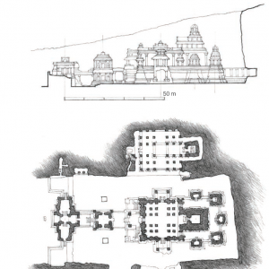
凯拉萨神庙 TEMPLE OF KAILASNATH德干高原的控制权在公元750年左右被拉什特拉库塔人从查鲁基亚人手中夺走,拉什特拉库塔人统治了约两个世纪,直到公元973年。拉什特拉库塔人迅速确立了他们的军事优势,占领了连接西部地区和次大陆其他地区的至关重要的贸易路线,特别是达克希纳帕塔(dakshinapatha),即南部路线。在Verul的dakshinapatha(当代埃罗拉),Rash ...
乌鲁克白色神庙 White Temple at Uruk公元前3000周围棱堡消失。乌鲁克白色神庙 White Temple at Uruk
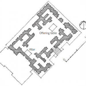
埃利都神庙 Temple at Eridu公元前3500年公元前3500年至公元前3000年间,苏美尔人在乌鲁克附近的埃利都(Eridu)修建了一座神庙,它现在被人称做第八神庙,其布局具有典型苏美尔特征,与后来著名的古地亚王(Gudea,公元前2150年)雕像腿部所绘的宫殿布局相似。整体布局为矩形,中心的庭院周围设置多座棱堡(似乎是源于早期的军事建筑模式)。横向的一边上设置有 ...
卡尔利支提石窟 CAITYA HALL AT KARLI到公元3世纪,印度的一些地方已经修建了caitya会堂。其中最大、最令人印象深刻的一座建于公元120年,位于德干高原西部的卡里。大约40米深,12米宽,Karli圣所的正面是一个凹进去的石屏入口,石屏上有洞,这表明最初,一个更大的木质建筑被添加到建筑中。在屏幕的左边,有一根大柱子,和洞穴的其他部分是用同样的基质雕 ...
叙利亚马里古城 CITY OF MARI如果没有骆驼和马,我们今天的世界将会有多么不同。有了骆驼,商人们现在可以穿越向东和向西绵延数千英里的沙漠和山脉,把亚洲分割成南北两个独立的区域。到公元前2000年中期,商队带着多达600只动物穿梭在穿越沙漠平原的贸易路线上。第一个将这种贸易货币化的地方是一个叫马里的城市。它位于今天的叙利亚幼发拉底河西岸,从公 ...
公元前663年,亚述人甚至洗劫了埃及城市底比斯。他们是第一个指挥真正铁器时代军队的人。虽然与美索不达米亚的宗教活动有关,但新亚述人,以阿苏尔神为他们的万神殿的顶端,强加了一个特别严格的规则,神批准的战争。他们的工程师建造桥梁、隧道、护城河和各种武器。到公元前668年,亚述控制了埃及和尼罗河流域。杜尔沙鲁金 Dur-Sharrukin萨尔贡二世(公元 ...
乌尔古城,西亚苏美尔–阿卡德时代城市,是世界上最早的城市之一。遗址位于伊拉克巴格达市东南约300千米处的穆盖伊尔。19世纪中叶,英国地理学者开始进行发掘研究。1922~1934年,英国考古学家L.吴雷领导的考古队进行系统发掘。乌尔城址的早期地层堆积分属欧贝德文化和乌鲁克文化,晚期地层堆积属苏美尔早王朝及以后各时代。这一遗址的发掘,对研究这一地 ...
莱基城址 City Site of Lachish 古代巴勒斯坦城市遗址。位于耶路撒冷西南约40公里处,即现在的杜韦尔土丘。莱基之名曾见于阿马尔奈文书和《圣经》,年代为公元前第4千年至前2世纪。1932~1938年,J.L.斯塔基主持发掘了遗址的一小部分。 最早的遗迹是遗址外围的一些青铜时代早期的洞穴居址。青铜时代中期,这里出现了城市。发掘出带有壕沟和堡垒的城墙、一 ...
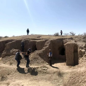
喀拉秋别(Kara-Tepe)佛寺遗址。遗址位于蒙古大军毁掉的铁尔梅兹古城西侧山丘上,属于边防控制区。我们先到山丘东侧距铁尔梅兹古城遗址很近的边防站,到边防军那里递交文件。斜挎冲锋枪的军人上车核对人数、证件之后,我们绕到山丘北侧进入遗址区。法浩特叮嘱我们不要到山丘顶部拍照,让哨楼上的士兵看见会有麻烦。一边听法浩特介绍寺院形制、发掘情况, ...
科基尔多尔·奥塔(Kokildor Ota)苏菲修行院科基尔多尔·奥塔哈纳卡位于铁尔梅兹,建于11世纪中叶。这座建筑是一处神圣的宗教场所,在伊斯兰世界中享有极高的声望。该哈纳卡以其独特的布局和建筑风格而著称。研究者认为,这座建筑在15世纪经历了重建,并在前方开放式立面上增建了一座宏伟的门廊。Kokildor-Ota Khanaka, TermezKhanaka-Mausoleum Kokildor ...
法亚兹特佩佛教寺院遗址位于乌兹别克斯坦铁尔梅兹市西北9 公里的铁尔梅兹古城遗址西北的山丘上,周边均为耕地和空地。其西1 公里为阿姆河, 南0.9 公里为卡拉特佩佛教寺院遗址, 东南1 公里为铁尔梅兹古城遗址。
和田县佛教圣地牛头山佛教圣地牛头山位于和田市西南约23公里的库玛尔山。牛头山是于阗著名的佛教圣地,在中原佛教徒的心目中占有崇高的地位。牛头山的名字与形象屡见于汉文史籍、汉译佛经、敦煌遗书乃至敦煌壁画,唐玄奘在《大唐西域记》中有记载,古时因此山有两角突起,状如牛头上的双角,故称牛头山,或牛角山。牛头山地处喀拉喀什河北岸,山体为砂砾岩 ...
Remains of Vikramshila Ancient UniversityBiharBhagalpur42.3525 19 N 87 17 E
Mound LocallyKnown as BurudKot (NallaSopara Stupa)Maharashtra,Dist.-ThaneTehsil-VasaiLocality- NallaSopara1.0415Hect.19 25N 72 47E
Ancient monastery and stupa together with adjacent land (Harwan)Jammu Kashmir, Kashmir Valley74 kanals 06 Marla34 9N 74 84E
Excavated Remains of Kaveripattinam(Excavated remains of Buddhist vihara and temple at Pallavaneswaram-Melaiyur)Nagapattinam district,Tamil Nadu0.405 hec(1.03 acres)11 12 50 N79 52 50 E
Ancient Site and Buddhist Stupa (Sanghol)"State- Punjab, Distt. Fatehgarh Sahib, Tehsil- Khamanu, Locality- Sanghol (Uncha Pind)220mX200m30 47N 76 23E
6.AhichhatraRamnagar, tehsil Aonla, district Barreilly, Uttar Pradesh187.545
尸罗夫(Siraf)是中世纪波斯湾著名港口,位于伊朗布什尔省(Bushehr)南部村庄塔赫里(Tahiri)以西1.5英里(约0.93公里)处。在中世纪,驶往波斯湾的东方船只往往沿海岸线航行,驶入波斯湾后,大部分在北岸的尸罗夫港装卸货物,少部分继续向北航行,最后抵达处于两河流域(底格里斯河和幼发拉底河)河口的乌剌港(今伊拉克巴士拉附近)。波斯和阿拉伯帝 ...
Description Territory of the reserve referred to the Central Asian natural climatic range with highland Zorkul Lake of glacial origin. This lake situated on the altitude of 4100-4200 m. Within the te
Description The botanical zakaznik (reserve) Kusavlisay situated on the North slopes of Turkestan mountain ridge to the north direction from Shahristan pass of Dushanbe – Hodjent road. It is contiguo